
File:Map of the Medway Megaliths.jpg

Map_of_the_Medway_Megaliths.jpg (694 × 494 pixels, file size: 146 KB, MIME type: image/jpeg)
| The uploader or another editor requests that a local copy of this file be kept. This image or media file may be available on the Wikimedia Commons as File:Map of the Medway Megaliths.jpg. While the license of this file may be compliant with the Wikimedia Commons, an editor has requested that the local copy be kept too. This file does not meet CSD F8 and should not be tagged as a Commons duplicate. If you desire to nominate it for deletion, notify the tagging editor. |
Summary[edit]
| Description |
A plan of the Medway Megaliths, a series of Early Neolithic chambered tombs clustered around the River Medway in Kent, England. Created by uploader based upon example in page 2 of Wysocki, Michael; Griffiths, Seren; Hedges, Robert; Bayliss, Alex; Higham, Tom; Fernandez-Jalvo, Yolanda; Whittle, Alasdair (2013). "Dates, Diet and Dismemberment: Evidence from the Coldrum Megalithic Monument, Kent". Proceedings of the Prehistoric Society. Prehistoric Society. 79: 1–30. |
|---|---|
| Source |
Own work |
| Date | |
| Author |
Midnightblueowl (talk) (Uploads) (after Wysocki et al 2013: 2) |
| Permission (Reusing this file) |
See below.
|
Licensing[edit]
| This work is licensed under the Creative Commons Attribution-ShareAlike 3.0 License. |
 | Permission is granted to copy, distribute and/or modify this document under the terms of the GNU Free Documentation License, Version 1.2 or any later version published by the Free Software Foundation; with no Invariant Sections, no Front-Cover Texts, and no Back-Cover Texts. |
File history
Click on a date/time to view the file as it appeared at that time.
| Date/Time | Thumbnail | Dimensions | User | Comment | |
|---|---|---|---|---|---|
| current | 16:39, 18 January 2020 | 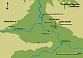 | 694 × 494 (146 KB) | Hohum (talk | contribs) | Reworked, more cartgraphical colouring |
| 20:57, 8 October 2015 |  | 694 × 494 (32 KB) | Midnightblueowl (talk | contribs) | Colour alteration; this version is less garish and the river has been converted from black to blue, as it more befitting a body of water. | |
| 14:17, 30 January 2014 |  | 694 × 494 (35 KB) | Midnightblueowl (talk | contribs) | Map of the Medway Megaliths, created by User:Midnightblueowl. |
You cannot overwrite this file.
File usage
The following file is a duplicate of this file (more details):
- File:Map of the Medway Megaliths.jpg from Commons