
File:402 through Sarnia.png

Size of this preview: 800 × 439 pixels. Other resolutions: 320 × 175 pixels | 640 × 351 pixels | 1,024 × 561 pixels | 1,280 × 702 pixels | 1,979 × 1,085 pixels.
Original file (1,979 × 1,085 pixels, file size: 3.98 MB, MIME type: image/png)
Summary[edit]
| Description |
Aerial view of Highway 402 passing through Sarnia. The Blue Water Bridge is visible, and Lake Huron can be seen at the top of the image, still frozen.
| |||
|---|---|---|---|---|
| Source |
Derivative of [1] | |||
| Date |
March 24, 2008 | |||
| Author | ||||
| Permission (Reusing this file) |
|
File history
Click on a date/time to view the file as it appeared at that time.
| Date/Time | Thumbnail | Dimensions | User | Comment | |
|---|---|---|---|---|---|
| current | 20:52, 9 February 2017 | 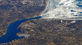 | 1,979 × 1,085 (3.98 MB) | Jeanjung212 (talk | contribs) | Lossless Compressed/optimized png decreasing file size by 18207 bytes |
| 15:20, 22 October 2011 |  | 1,979 × 1,085 (4 MB) | Floydian (talk | contribs) | {{Information |Description=Aerial view of Highway 402 passing through Sarnia. The Blue Water Bridge is visible, and Lake Huron can be seen at the top of the image, still frozen. |Source=Derivative of [http://www.flickr.com/photos/docsearls/2466554248/in/p |
You cannot overwrite this file.
File usage
The following file is a duplicate of this file (more details):
- File:402 through Sarnia.png from Commons
The following pages on the English Wikipedia use this file (pages on other projects are not listed):