
Fier railway station
Fier | |
|---|---|
| Hekurudha Shqiptare | |
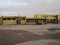
 The station in 2014 | |
| General information | |
| Coordinates | 40°43′48″N 19°33′13″E / 40.7299°N 19.5535°E |
| Operated by | Hekurudha Shqiptare |
| Line(s) | Durrës-Vlorë railway |
| Platforms | 2 |
| History | |
| Opened | 13 October 1968 |
| Location | |
.svg) Fier station Location within Albania  Fier station Fier station (Europe) | |
 | |
Fier railway station (Albanian: Stacioni hekurudhor i Fier) is a railway station that serves the city of Fier in Fier County, Albania.
The station opened in 1968 after an extension from Rrogozhine was completed. It was a terminus until the line was extended southwards to Ballsh in 1975, though passenger services south of Fier did not commence until 1985.[1]
Like Laç, Fier was a busy transportation hub in the days of the People's Socialist Republic of Albania for ores and fertiliser freight at a time when road infrastructure was still underdeveloped. In 1991, the International Fertilizer Development Center reported that 80-90% of fertiliser produced in Fier and Laç was transported by rail. Although the journey estimates were optimistic, the transportation methods were not suitable and were in need of revision.[2]
Gallery[edit]
-
 Street facade of the station building in 2014.
 -
 The waiting room at Fier station in 2014.
 -
 The station platforms in 2014.
 -
 Train approaching the station in 2014.


References[edit]
- ^ "Opening Dates of HSH Standard Gauge Lines". Retrieved 21 September 2017.
- ^ "Supply, Distribution, and Marketing of Fertilizer and Other Key Agricultural Inputs" (PDF). Retrieved 21 September 2017.pg.29
External links[edit]
- (in Albanian and English) Hekurudha Shqiptare (Albanian Railways)
This article about a building or structure in Albania is a stub. You can help Wikipedia by expanding it. |
This article about a European railroad station is a stub. You can help Wikipedia by expanding it. |