
Etzgen
You can help expand this article with text translated from the corresponding article in German. (February 2009) Click [show] for important translation instructions.
|
Etzgen | |
|---|---|
 Coat of arms | |
Location of Etzgen  | |
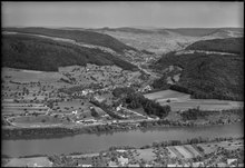
 Etzgen  Etzgen | |
| Coordinates: 47°34′N 8°7′E / 47.567°N 8.117°E | |
| Country | Switzerland |
| Canton | Aargau |
| District | Laufenburg |
| Area | |
| • Total | 3.28 km2 (1.27 sq mi) |
| Elevation | 336 m (1,102 ft) |
| Population (December 2006) | |
| • Total | 438 |
| • Density | 130/km2 (350/sq mi) |
| Time zone | UTC+01:00 (Central European Time) |
| • Summer (DST) | UTC+02:00 (Central European Summer Time) |
| Postal code(s) | 5275 |
| SFOS number | 4162 |
| ISO 3166 code | CH-AG |
| Surrounded by | Albbruck (DE-BW), Laufenburg (DE-BW), Mettau, Oberhofen, Schwaderloch, Sulz |
| Website | www SFSO statistics |
Etzgen was a municipality in the district of Laufenburg in the canton of Aargau in Switzerland. On 1 January 2010, the municipalities of Hottwil, Etzgen, Mettau, Oberhofen AG and Wil AG merged into the municipality of Mettauertal.[1]
Economy[edit]
In 2000 (before the merger)[update], there were 163 workers who lived in the municipality. Of these, 119 or about 73.0% of the residents worked outside Etzgen while 112 people commuted into the municipality for work. There were a total of 156 jobs (of at least six hours per week) in the municipality.[2]
References[edit]
- ^ Amtliches Gemeindeverzeichnis der Schweiz, Mutationsmeldungen 2009 / Répertoire officiel des communes de Suisse, Mutations 2009 / Elenco ufficiale dei Comuni della Svizzera, Mutazione 2009 (PDF) (Report). Federal Statistical Office. 2009. 3170. Archived from the original (PDF) on 18 November 2010. Retrieved 6 March 2010.
- ^ Statistical Department of Canton Aargau-Bereich 11 Verkehr und Nachrichtenwesen Archived 2012-02-22 at the Wayback Machine (in German) accessed 21 January 2010
External links[edit]
Wikimedia Commons has media related to Etzgen.
- Etzgen in German, French and Italian in the online Historical Dictionary of Switzerland.
This Aargau location article is a stub. You can help Wikipedia by expanding it. |