
Egmont Bight

Egmont Bight is a shallow embayment at the southern end of the Encombe valley in Dorset, England. It is part of the Jurassic Coast.
Geology[edit]
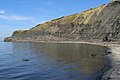
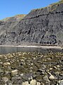
The bay exposes good sections of Upper Kimmeridge shale and mudstone, with some bituminous shale and some small calcareous nodules.[1]

On foot the stony beach is only accessible at low tide by walking 1.0-kilometre (0.6 mi) west around Egmont Point from the beach at Chapman's Pool. There is no safe route down from the clifftop coast path, across Houns-tout cliff, nor around the Freshwater Steps promontory at the beach's western end.
See also[edit]
References[edit]
Gallery[edit]
-
 Egmont Bight
 -
 Stony beach, Egmont Bight
 -
 East end of the beach
 -
 West end of the beach
 -
 East side of the small Freshwater Steps promontory
 -
 Cliff-fall of shale on the beach


50°35′42″N 2°4′38″W / 50.59500°N 2.07722°W
This Dorset location article is a stub. You can help Wikipedia by expanding it. |