
East Camden, South Carolina
East Camden, South Carolina | |
|---|---|
 East Camden  East Camden | |
| Coordinates: 34°16′6″N 80°34′2″W / 34.26833°N 80.56722°W | |
| Country | United States |
| State | South Carolina |
| County | Kershaw |
| Area | |
| • Total | 3.58 sq mi (9.27 km2) |
| • Land | 3.58 sq mi (9.27 km2) |
| • Water | 0.00 sq mi (0.00 km2) |
| Elevation | 283 ft (86 m) |
| Population | |
| • Total | 3,215 |
| • Density | 898.04/sq mi (346.73/km2) |
| Time zone | UTC-5 (Eastern (EST)) |
| • Summer (DST) | UTC-4 (EDT) |
| ZIP Code | 29020 (Camden) |
| Area code(s) | 803/839 |
| FIPS code | 45-22050 |
| GNIS feature ID | 2807063[3] |
East Camden is an unincorporated area and census-designated place (CDP) in Kershaw County, South Carolina, United States. It was first listed as a CDP prior to the 2020 census[3] with a population of 3,215.[4]
East Camden is in south-central Kershaw County, bordered to the southwest and south by the city of Camden, the county seat. The CDP includes the community of Du Bose Park. U.S. Route 1 passes through the CDP, leading southwest into Camden and northeast 18 miles (29 km) to Bethune.
Demographics[edit]
| Census | Pop. | Note | %± |
|---|---|---|---|
| 2020 | 3 | — | |
| U.S. Decennial Census[5] 2020[6][2] | |||
2020 census[edit]
| Race / Ethnicity | Pop 2020[6] | % 2020 |
|---|---|---|
| White alone (NH) | 2,016 | 62.71% |
| Black or African American alone (NH) | 737 | 22.92% |
| Native American or Alaska Native alone (NH) | 2 | 0.06% |
| Asian alone (NH) | 9 | 0.28% |
| Pacific Islander alone (NH) | 0 | 0.00% |
| Some Other Race alone (NH) | 11 | 0.34% |
| Mixed Race/Multi-Racial (NH) | 114 | 3.55% |
| Hispanic or Latino (any race) | 326 | 10.14% |
| Total | 3,215 | 100.00% |
Note: the US Census treats Hispanic/Latino as an ethnic category. This table excludes Latinos from the racial categories and assigns them to a separate category. Hispanics/Latinos can be of any race.
References[edit]
- ^ "ArcGIS REST Services Directory". United States Census Bureau. Retrieved October 15, 2022.
- ^ a b "Census Population API". United States Census Bureau. Retrieved October 15, 2022.
- ^ a b "East Camden Census Designated Place". Geographic Names Information System. United States Geological Survey, United States Department of the Interior.
- ^ "East Camden CDP, South Carolina". United States Census Bureau. Retrieved April 15, 2022.
- ^ "Decennial Census of Population and Housing by Decades". US Census Bureau.
- ^ a b "P2 HISPANIC OR LATINO, AND NOT HISPANIC OR LATINO BY RACE – 2020: DEC Redistricting Data (PL 94-171) – East Camden CDP, South Carolina". United States Census Bureau.
Municipalities and communities of Kershaw County, South Carolina, United States | ||
|---|---|---|
| City | 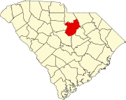 | |
| Towns | ||
| CDPs | ||
| Other communities | ||
This South Carolina state location article is a stub. You can help Wikipedia by expanding it. |