
Dyersville, Colorado

Dyersville was a mining town — now a ghost town — in Summit County, Colorado, United States. It was named after Methodist minister John Lewis Dyer. Nothing remains of the town except the roofless walls of a couple of log cabins.
History[edit]
Methodist minister and prospector John Lewis Dyer, better known as "Father" Dyer, built a cabin in a secluded location along the upper reaches of Indiana Creek in January 1881. He was soon joined in his seclusion by miners and merchants connected to the nearby Warrior's Mark mine. The community named itself after its first resident, Father Dyer.[1]
Notable residents[edit]
- John Lewis Dyer, pioneer Methodist minister.
Geography[edit]
The site of Dyersville, is at 39°25′14″N 105°59′02″W / 39.4206°N 105.9839°W, at an elevation of 10,880 feet (3,316 m). The site is in Indiana Gulch, 6 miles (10 km) southeast of Breckenridge, Colorado.
See also[edit]
- Bibliography of Colorado
- Geography of Colorado
- History of Colorado
- Index of Colorado-related articles
- List of Colorado-related lists
- Outline of Colorado
References[edit]
- ^ Mark Fiester (1980) Look for me in Heaven, Boulder, Colo.: Pruett, p.380-385.
External links[edit]
 Media from Commons
 News from Wikinews
 Quotations from Wikiquote
 Travel information from Wikivoyage
- State of Colorado
- Rocky Mountain Profiles: Dyersville Colorado Townsite - Ghost town
- Ghosttowns.com: Dyersville
Municipalities and communities of Summit County, Colorado, United States | ||
|---|---|---|
| Towns | 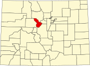 | |
| CDPs | ||
| Ghost towns |
| |
This Colorado state location article is a stub. You can help Wikipedia by expanding it. |
This United States ghost town-related article is a stub. You can help Wikipedia by expanding it. |