
Decauville railway Narès–Inglis–Topçin–Vatiluk
| Decauville railway Narès–Inglis–Topçin–Vatiluk | ||||||||||||||||||||||||||||||||||||||||||||||||||||||
|---|---|---|---|---|---|---|---|---|---|---|---|---|---|---|---|---|---|---|---|---|---|---|---|---|---|---|---|---|---|---|---|---|---|---|---|---|---|---|---|---|---|---|---|---|---|---|---|---|---|---|---|---|---|---|
.png) Bridge over the Vatiluk Gorge< | ||||||||||||||||||||||||||||||||||||||||||||||||||||||
| Technical | ||||||||||||||||||||||||||||||||||||||||||||||||||||||
| Line length | 30–35 km (19–22 mi) | |||||||||||||||||||||||||||||||||||||||||||||||||||||
| Track gauge | 600 mm (1 ft 11+5⁄8 in) | |||||||||||||||||||||||||||||||||||||||||||||||||||||
| ||||||||||||||||||||||||||||||||||||||||||||||||||||||
.jpg)
The Decauville railway Narès–Inglis–Topçin–Vatiluk was around 1916 a 30–35 km (19–22 mi) long narrow-gauge military railway near Thessaloniki in Greece with a gauge of 600 mm (1 ft 11+5⁄8 in)
Route[edit]
The 30–35 km (19–22 mi) long semicircular narrow gauge network with a track gauge of 600 mm (1 ft 11+5⁄8 in) from Narès (now Nea Filadelfeia, Νέα Φιλαδέλφεια) via Bumardza (now Bougaríevo, Μπουγαρίεβο), Sari-Omer (Σαρή Ομέρ), Inglis (now Anchialos, Αγχίαλος) and Topçin (now Gefyra, Γέφυρα) to Vatiluk (now Vathylakkos, Βαθύλακκος).[1]
-
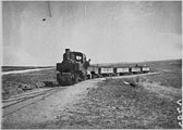 Near Topçin, June 1916
 -
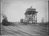 Inglis station
 -
 Tents
Tents -
 Station, Dec. 1916
 -
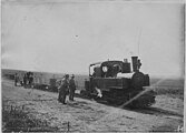 Decauville loco
._Le_Decauville_allant_sur_Top%C3%A7in.jpg)
._Gare_d%27Inglis.jpg)
._La_gare_02.jpg)
._La_gare.jpg)
._Le_Decauville.jpg)
References[edit]
- ^ Vatiluk (Kadikjöј). In: Military Mapping Survey of Austria-Hungary, around 1910.
Wikimedia Commons has media related to Decauville railway Nares-Vatiluk.
| Railways |
| ||||||||
|---|---|---|---|---|---|---|---|---|---|
| Tramways |
| ||||||||
| Factories |
| ||||||||
| Related | |||||||||