
Columbine Peak
| Columbine Peak | |
|---|---|
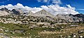
 West aspect | |
| Highest point | |
| Elevation | 12,662 ft (3,859 m)[1] |
| Prominence | 542 ft (165 m)[1] |
| Parent peak | North Palisade (14,242 ft)[2] |
| Isolation | 1.37 mi (2.20 km)[2] |
| Coordinates | 37°05′21″N 118°32′30″W / 37.0891644°N 118.5418027°W[3] |
| Geography | |
 Columbine Peak Location in California  Columbine Peak Columbine Peak (the United States) | |
| Location | Kings Canyon National Park Fresno County California, U.S. |
| Parent range | Sierra Nevada Palisades[1] |
| Topo map | USGS North Palisade |
| Geology | |
| Type of rock | granite |
| Climbing | |
| First ascent | < 1925 |
| Easiest route | class 2 by northeast or south ridge[4] |
Columbine Peak is a 12,662-foot-elevation (3,859 meter) mountain summit located 1.5 miles (2.4 km) west of the crest of the Sierra Nevada mountain range, in Fresno County of northern California, United States.[3] It is situated between Palisade Basin and Dusy Basin in the Palisades area of northern Kings Canyon National Park. It is 1.54 miles (2.48 km) west of North Palisade, 2 miles (3.2 km) south of Bishop Pass, and immediately north of Knapsack Pass. This mountain's name has been officially adopted by the United States Board on Geographic Names.[3] The first ascent of the summit was made prior to 1925 by persons unknown.[5]
Climate[edit]
According to the Köppen climate classification system, Columbine Peak is located in an alpine climate zone.[6] Most weather fronts originate in the Pacific Ocean, and travel east toward the Sierra Nevada mountains. As fronts approach, they are forced upward by the peaks, causing them to drop their moisture in the form of rain or snowfall onto the range (orographic lift). Precipitation runoff from this mountain drains into tributaries of the Middle Fork Kings River.
Gallery[edit]
-
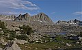
 Columbine Peak (right) from Dusy Basin
 -
 Columbine Peak (centered) from Dusy Basin. Isosceles Peak to left.
 -
 Columbine Peak (centered) from Dusy Basin.


See also[edit]
References[edit]
- ^ a b c "Columbine Peak, California". Peakbagger.com. Retrieved 2021-04-23.
- ^ a b "Columbine Peak - 12,662' CA". listsofjohn.com. Retrieved 2021-04-17.
- ^ a b c "Columbine Peak". Geographic Names Information System. United States Geological Survey, United States Department of the Interior. Retrieved 2021-04-23.
- ^ Hervey Voge and David R. Brower, A Climber's Guide to the High Sierra (1954)
- ^ Hervey Voge and David R. Brower, A Climber's Guide to the High Sierra (1954)
- ^ Peel, M. C.; Finlayson, B. L.; McMahon, T. A. (2007). "Updated world map of the Köppen−Geiger climate classification". Hydrol. Earth Syst. Sci. 11. ISSN 1027-5606.
External links[edit]
- Weather forecast: Columbine Peak
- Columbine Peak Rock Climbing: Mountainproject.com