
Claysville, Alabama
Claysville, Alabama | |
|---|---|
 Claysville  Claysville | |
| Coordinates: 34°24′28″N 86°16′19″W / 34.40778°N 86.27194°W | |
| Country | United States |
| State | Alabama |
| County | Marshall |
| Elevation | 623 ft (190 m) |
| Time zone | UTC-6 (Central (CST)) |
| • Summer (DST) | UTC-5 (CDT) |
| Area code(s) | 256 & 938 |
| GNIS feature ID | 156187[1] |
Claysville is an unincorporated community in Marshall County, Alabama, United States.
History[edit]
Claysville was named in honor of Henry Clay, and served as the county seat of Marshall County from 1836 to 1838.[2] During the American Civil War, Claysville became a strategic location, due to the ferry crossing of the Tennessee River. A Union Army garrison was located here during the latter part of the war.[3] The 13th Wisconsin Volunteer Infantry Regiment was stationed here under the command of Colonel William P. Lyon.[4] A post office operated under the name Claysville from 1831 to 1879.[5]
References[edit]
- ^ "Claysville". Geographic Names Information System. United States Geological Survey, United States Department of the Interior.
- ^ Foscue, Virginia (1989). Place Names in Alabama. Tuscaloosa: The University of Alabama Press. p. 35. ISBN 0-8173-0410-X.
- ^ Samuel Gillespie; James E. Steele (1909). History of Clay County, Iowa: From Its Earliest Settlement to 1909. S.J. Clarke Publishing Company. pp. 638–.
- ^ Magazine of Western History. 1887. p. 849. Retrieved November 30, 2014.
- ^ "Marshall County". Jim Forte Postal History. Archived from the original on November 29, 2014. Retrieved October 21, 2014.
Municipalities and communities of Marshall County, Alabama, United States | ||
|---|---|---|
| Cities | 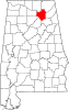 | |
| Towns | ||
| CDPs | ||
| Unincorporated communities | ||
| Ghost town | ||
| Footnotes | ‡This populated place also has portions in an adjacent county or counties | |
This Marshall County, Alabama state location article is a stub. You can help Wikipedia by expanding it. |