
Cherry Burton
| Cherry Burton | |
|---|---|
.jpg) St Michael and All Angels Church | |
 Cherry Burton Location within the East Riding of Yorkshire | |
| Population | 1,392 (2011 census)[1] |
| OS grid reference | SE989420 |
| • London | 165 mi (266 km) S |
| Civil parish |
|
| Unitary authority | |
| Ceremonial county | |
| Region | |
| Country | England |
| Sovereign state | United Kingdom |
| Post town | BEVERLEY |
| Postcode district | HU17 |
| Dialling code | 01964 |
| Police | Humberside |
| Fire | Humberside |
| Ambulance | Yorkshire |
| UK Parliament | |
Cherry Burton is a village and civil parish in the East Riding of Yorkshire, England. It is approximately 3 miles (5 km) north-west of the market town of Beverley,[2] 9 miles (14 km) east of Market Weighton and 11 miles (18 km) south west of Driffield.[3] The village lies on the eastern edge of the Yorkshire Wolds and lies to the west of the B1248 road.[4]
History
[edit]The village is mentioned in the Domesday Book as Burtone, and belonging to the then Archbishop of York.[5] The name derives from a combination of Old and Middle English; Burh-tūn and Chiri, which means a fort enclosure; a farm with a palisade and a cherry tree.[6] Due to its location, some 1.2 miles (2 km) north of Bishop Burton, the village was sometimes known as North Burton (or even rarer, as Sheriff Burton).[7][8]
Historically in the Wapentake of Harthill, the village also came under the Beverley for its local district.[9][10] Until rapid housebuilding in the 1960s and 1970s, the village mostly consisted of one long main street as laid down in the 18th and 19th centuries with farmhouses.[11]
The civil parish is formed by the village of Cherry Burton and the hamlets of Gardham and High Gardham. According to the 2011 UK Census, Cherry Burton parish had a population of 1,392,[1] a reduction on the 2001 UK Census figure of 1,473.[12]
The village has a Costcutter shop which also acts as a post office and a village hall which holds live musical events and hosts an annual local pantomime. The village pub, The Bay Horse, holds events each week.[13] The village has a primary school which has ties with the local church. Its rating by OFSTED is good.[14]
Sports in the village include cricket, football, tennis, and rounders. Clubs for cricket and football have junior sections. Just outside of the village is a golf course and leisure park currently under development. A Wesleyan Methodist chapel was built in 1824, followed by a Primitive Wesleyan Methodist chapel in 1851; both have ceased being used for worship with the Wesleyan chapel now being the village hall.[13] An Anglican church was also built in the village in 1852, which is now grade II listed.[15] It was built on the site of a previous undated church.[16]
The village is one of the few in the UK awarded Fairtrade Village status for promoting fairtrade and local produce. It gained this status on 22 July 2003 and was the second village to do so.[17][18] In 2011–2012, a flood alleviation scheme was implemented with funding from DEFRA. Like many other places in the East Riding of Yorkshire, Cherry Burton was subject to severe flooding in the 2007 floods.[19]
Cherry Burton was served by Cherry Burton railway station on the York to Beverley Line between 1865 and 1959,[20] with the station remaining open for another five years for the inward and outward transportation of agricultural produce. The line closed completely in 1965.[21] In 2018, a new footpath from the village to the old railway line opened, which allowed the inhabitants of Cherry Burton to access the Hudson Way, a foot and cycle path built on the formation of the old railway line.[22] Previous to this, to access the path, villagers needed to negotiate the main road out of the village which had no footpaths and where traffic could travel at 60 miles per hour (97 km/h).[13]
Gallery
[edit]-
 Aerial Photo Cherry Burton c. 1960
 -
 Cherry Burton Cricket Club team photo, 15 May 2008
 -
 A winter day in Cherry Burton
 -
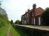 Cherry Burton railway station
 -
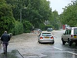 Cherry Burton in the 2007 floods


References
[edit]- ^ a b UK Census (2011). "Local Area Report – Cherry Burton Parish (1170211162)". Nomis. Office for National Statistics. Retrieved 16 February 2018.
- ^ "Genuki: Cherry Burton, Yorkshire (East Riding)". www.genuki.org.uk. Retrieved 13 January 2020.
- ^ Langdale, Thomas (1809). A topographical dictionary of Yorkshire : containing the names of all the towns, villages, hamlets, gentlemen's seats, &c. in the county of York. Northallerton: J Langdale. p. 98. OCLC 427481667.
- ^ "293" (Map). Kingston upon Hull & Beverley. 1:25,000. Explorer. Ordnance Survey. 2015. ISBN 9780319244906.
- ^ "[Cherry] Burton | Domesday Book". opendomesday.org. Retrieved 13 January 2020.
- ^ Ekwall, Eilert (1960). The concise Oxford dictionary of English place-names (4 ed.). Oxford: Oxford University Press. pp. 77–78. ISBN 0-19-869103-3.
- ^ Oliver, George (1829). he history and antiquities of the town and minster of Beverley, in the county of York, from the most early period. Beverley: Turner. p. 496. OCLC 3552084.
- ^ Peach, Howard (2001). Curious tales of old East Yorkshire. Wilmslow: Sigma Leisure. p. 172. ISBN 1-85058-749-3.
- ^ "Genuki: CHERRY BURTON: Geographical and Historical information from the year 1892., Yorkshire (East Riding)". www.genuki.org.uk. Retrieved 13 January 2020.
- ^ "History of Cherry Burton, in East Riding of Yorkshire and East Riding | Map and description". www.visionofbritain.org.uk. Retrieved 13 January 2020.
- ^ Pevsner, Nikolaus (2002). Yorkshire : York and the East Riding (2 ed.). London: Yale University Press. p. 384. ISBN 0-300-09593-7.
- ^ UK Census (2001). "Local Area Report – Cherry Burton Parish (1543504209)". Nomis. Office for National Statistics. Retrieved 7 December 2018.
- ^ a b c McCandlish, Sophie (12 January 2020). "A village rooted in agriculture and Fairtrade". The Yorkshire Post. Retrieved 13 January 2020.
- ^ "Cherry Burton Church of England Voluntary Controlled Primary School URN: 118002". reports.ofsted.gov.uk. 16 October 2019. Retrieved 13 January 2020.
- ^ Historic England. "Church of St Michael (Grade II) (1310173)". National Heritage List for England. Retrieved 13 January 2020.
- ^ Pevsner, Nikolaus (2002). Yorkshire : York and the East Riding (2 ed.). London: Yale University Press. p. 383. ISBN 0-300-09593-7.
- ^ "Fairtrade - Towns List". Fairtrade Foundation. Archived from the original on 1 February 2010. Retrieved 25 July 2008.
- ^ "Welcome to the Cherry Burton Fairtrade and Local Produce Project". Cherry Burton Fairtrade and Local Produce Project. Retrieved 19 August 2009.
- ^ "Work starts on scheme to prevent flooding". The Yorkshire Post. 6 December 2011. Retrieved 13 January 2020.
- ^ Butt, R. V. J. (October 1995). The Directory of Railway Stations: details every public and private passenger station, halt, platform and stopping place, past and present (1st ed.). Sparkford: Patrick Stephens Ltd. p. 59. ISBN 978-1-85260-508-7. OCLC 60251199. OL 11956311M.
- ^ "Disused Stations: Cherry Burton Station". disused-stations.org.uk. Retrieved 13 January 2020.
- ^ "TROD Path to Etton Bridge". Cherry Burton Parish Council. Retrieved 13 January 2020.
- Gazetteer — A–Z of Towns Villages and Hamlets. East Riding of Yorkshire Council. 2006. p. 4.
External links
[edit]- Cherry Burton in the Domesday Book
| Statutory City Region | |
|---|---|
| Unitary authorities | |
| Major settlements (cities in italics) | |
| Rivers | |
| Canals | |
| Topics | |
| International | |
|---|---|
| National | |