
Chaipat
Chaipat | |
|---|---|
Village | |
 Chaipat Location in West Bengal, India  Chaipat Chaipat (India) | |
| Coordinates: 22°34′09.6″N 87°48′17.3″E / 22.569333°N 87.804806°E | |
| Country | |
| State | West Bengal |
| District | Paschim Medinipur |
| Languages | |
| • Official | Bengali, English |
| Time zone | UTC+5:30 (IST) |
| PIN | 721148 |
| Telephone/STD code | 03225 |
| Lok Sabha constituency | Ghatal |
| Vidhan Sabha constituency | Daspur |
| Website | paschimmedinipur |
Chaipat is a village, in Daspur II CD Block in Ghatal subdivision of Paschim Medinipur district in the state of West Bengal, India.
Geography[edit]

5miles
M: municipal city/ town, R: rural/ urban centre, H: historical/ religious centre
Owing to space constraints in the small map, the actual locations in a larger map may vary slightly
Location[edit]
Chaipat is located at 22°34′09.6″N 87°48′17.3″E / 22.569333°N 87.804806°E.
Area overview[edit]
Ishwar Chandra Vidyasagar, scholar, social reformer and a key figure of the Bengal Renaissance, was born at Birsingha on 26 September 1820.[1][2]
Ghatal subdivision, shown in the map alongside, has alluvial soils. Around 85% of the total cultivated area is cropped more than once.[3] It has a density of population of 1,099 per km2, but being a small subdivision only a little over a fifth of the people in the district reside in this subdivision. 14.33% of the population lives in urban areas and 86.67% lives in the rural areas.[4]
Note: The map alongside presents some of the notable locations in the subdivision. All places marked in the map are linked in the larger full screen map.
Demographics[edit]
As per 2011 Census of India Chanipat had a total population of 16,345 of which 8,022 (49%) were males and 8,323 (51%) were females. Population below 6 years was 1,750. The total number of literates in Chanipat was 12,284 (75.15% of the population over 6 years).[5]
Transport and Popular Places[edit]
Kriya Yoga ashram at Chaipat satmatha, rajrajeswar Temple, Badur Bagan, Shiv-Sitala Temple. Chaipat is on the Gopiganj-Sultannagar Road. Sultannagar is on SH 4.[6]
Education[edit]
Chaipat Saheed Pradyot Bhattacharya Mahavidyalaya, established in 2007, is affiliated to Vidyasagar University. It offers honours courses in Bengali, English, Sanskrit and History.[7]
Chaipat High school was established in 1910, in British India .
Chaipat picture gallery[edit]
-
 Nava-ratna Rajrajesvara temple
 -
 Terracotta relief
 -
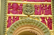 Terracotta relief


References[edit]
- ^ Murshid, Ghulam. "Vidyasagar, Pundit Iswar Chandra". Banglapedia. Retrieved 24 July 2016.
- ^ "Ishwar Chandra Vidyasagar". www.whereincity.com. Retrieved 24 July 2016.
- ^ "District Human Development Report Paschim Medinipur, 2011". page 27-28. Department of Planning and Statistics, Government of West Bengal. Retrieved 10 September 2020.
- ^ "District Statistical Handbook Paschim Medinipur, 2013". Table 2.2, 2.4 (a). Department of Planning and Statistics. Retrieved 10 September 2020.
- ^ "2011 Census – Primary Census Abstract Data Tables". West Bengal – District-wise. Registrar General and Census Commissioner, India. Retrieved 14 January 2007.
- ^ Google maps
- ^ "Chaipat Saheed Pradyot Bhattacharya Mahavidyalaya". CSPBM. Retrieved 14 January 2017.
https://schools.org.in/paschim-medinipur/19202904802/chaipat-high-school-u-pry.html
External links[edit]

This article about a location in the Paschim Medinipur district of West Bengal is a stub. You can help Wikipedia by expanding it. |