
Camiaca Peak
| Camiaca Peak | |
|---|---|
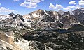
 East aspect, from Dunderberg Peak | |
| Highest point | |
| Elevation | 11,739 ft (3,578 m)[1] |
| Prominence | 1,259 ft (384 m)[2] |
| Parent peak | Twin Peaks (12,323 ft)[3] |
| Isolation | 1.88 mi (3.03 km)[3] |
| Listing | Vagmarken Club Sierra Crest List[4] |
| Coordinates | 38°03′36″N 119°19′27″W / 38.0600179°N 119.3242791°W[5] |
| Geography | |
 Camiaca Peak Location in California  Camiaca Peak Camiaca Peak (the United States) | |
| Location | Yosemite National Park Tuolumne / Mono counties California, United States |
| Parent range | Sierra Nevada |
| Topo map | USGS Dunderberg Peak |
| Geology | |
| Mountain type | Fault block |
| Type of rock | Metamorphic rock[6] |
| Climbing | |
| First ascent | 1917[7] |
| Easiest route | class 2 South slope[1] |
Camiaca Peak is an 11,739-foot-elevation (3,578 meter) mountain summit located on the crest of the Sierra Nevada mountain range in northern California, United States.[5] The peak is situated on the common boundary shared by Yosemite National Park with Hoover Wilderness, as well as the border shared by Mono County with Tuolumne County. It is approximately two miles east of Virginia Peak, three miles west of Dunderberg Peak, and Summit Lake lies at the base of the southeast slope. Topographic relief is significant as the west aspect rises nearly 2,000 feet (610 meters) above Return Creek in three-quarters mile.
History[edit]
The first ascent of the summit was made in 1917 by Walter L. Huber.[1]
This mountain's toponym was officially adopted in 1932 by the United States Board on Geographic Names.[5] The word "camiaca" possibly derives from the Southern Sierra Miwok "kamyaka" which means "yarrow" (a flowering plant).[8][9]
Climate[edit]
Camiaca Peak is located in an alpine climate zone.[10] Most weather fronts originate in the Pacific Ocean, and travel east toward the Sierra Nevada mountains. As fronts approach, they are forced upward by the peaks (orographic lift), causing moisture in the form of rain or snowfall to drop onto the range. Precipitation runoff from this mountain drains west into Return Creek, and east to Green Creek which is a tributary of Walker River.
See also[edit]
Gallery[edit]
-
 Southeast aspect centered, with Summit Lake visible below
 -
 Northeast aspect of Camiaca Peak with East Lake at the foot of the peak.


References[edit]
- ^ a b c R. J. Secor, The High Sierra Peaks, Passes, Trails, 2009, Third Edition, Mountaineers Books, ISBN 9781594857386, page 444.
- ^ "Camiaca Peak, California". Peakbagger.com. Retrieved 2022-05-07.
- ^ a b "Camiaca Peak - 11,739' CA". listsofjohn.com. Retrieved 2022-05-07.
- ^ "Vagmarken Sierra Crest List". Angeles Chapter, Sierra Club. Retrieved 2022-05-07.
- ^ a b c "Camiaca Peak". Geographic Names Information System. United States Geological Survey, United States Department of the Interior. Retrieved 2022-05-07.
- ^ Elizabeth Wenk (2021), Yosemite National Park: Your Complete Hiking Guide, 6th Edition, Wilderness Press, ISBN 9780899977850
- ^ Robert L. Swift and David A. Nelson, A Climber’s Guide to the High Sierra (1954)
- ^ Erwin G. Gudde (2010), California Place Names: The Origin and Etymology of Current Geographical Names, University of California Press, ISBN 9780520266193, p. 62
- ^ William Bright (2004), Native American Placenames of the United States, University of Oklahoma Press, ISBN 9780806135984, p. 78
- ^ "Climate of the Sierra Nevada". Encyclopædia Britannica.
External links[edit]
- Weather forecast: Camiaca Peak
Places adjacent to Camiaca Peak | ||||||||||||||||
|---|---|---|---|---|---|---|---|---|---|---|---|---|---|---|---|---|
| ||||||||||||||||