
Bullard Mountain
| Bullard Mountain | |
|---|---|
 Bullard Mountain, southwest aspect (Nugget Falls in lower left) | |
| Highest point | |
| Elevation | 4,225 ft (1,288 m)[1] |
| Prominence | 782 ft (238 m)[2] |
| Parent peak | Nugget Towers[1] |
| Coordinates | 58°26′03″N 134°30′09″W / 58.43417°N 134.50250°W[1] |
| Geography | |
 Bullard Mountain Location of Bullard Mountain in Alaska | |
| Location | Tongass National Forest Juneau Borough Alaska, United States |
| Parent range | Coast Mountains Boundary Ranges Juneau Icefield[1] |
| Topo map | USGS Juneau B-2 |
| Climbing | |
| Easiest route | Scrambling class 4 |
Bullard Mountain is a 4,225-foot (1,288 m) mountain summit located in the Boundary Ranges, in the U.S. state of Alaska.[3] The peak is situated immediately east of the terminus of Mendenhall Glacier, within Tongass National Forest, 9 mi (14 km) north-northwest of Juneau, and 6 mi (10 km) northeast of Juneau International Airport. McGinnis Mountain lies 3.7 mi (6 km) on the opposite side of the glacier, and Heintzleman Ridge lies 2.75 mi (4 km) to the south. Bullard Mountain is often seen and photographed with Mount Wrather, a 5,968-foot (1,819 m) summit 3.9 mi (6 km) to the north because they are together in the background behind Mendenhall Lake, a popular tourist and recreation area. Although modest in elevation, relief is significant since the mountain rises from this nearly sea-level lake in less than two miles. Precipitation runoff from the mountain drains into the lake via Nugget Creek and Nugget Falls. Bullard Mountain is named for Benjamin Bullard (1848-1933), a mining engineer who, in 1907, began mining on Nugget Creek where he later built a hydroelectric power plant.[4]
Climate[edit]
Based on the Köppen climate classification, Bullard Mountain is located in a subarctic climate zone with cold, snowy winters, and mild summers.[5] Temperatures can drop below −20 °C with wind chill factors below −30 °C. This climate supports the Mendenhall Glacier to the mountain's west. The month of July offers the most favorable weather for viewing and climbing this peak.
See also[edit]
References[edit]
- ^ a b c d "Bullard Mountain, Alaska". Peakbagger.com. Retrieved 2020-03-08.
- ^ Bullard Mountain, listsofjohn.com
- ^ "Bullard Mountain". Geographic Names Information System. United States Geological Survey, United States Department of the Interior. Retrieved 2020-03-08.
- ^ Dictionary of Alaska Place Names, Donald J. Orth author, United States Government Printing Office (1967), page 167
- ^ Peel, M. C.; Finlayson, B. L.; McMahon, T. A. (2007). "Updated world map of the Köppen−Geiger climate classification". Hydrol. Earth Syst. Sci. 11. ISSN 1027-5606.
Gallery[edit]
-
 Bullard Mountain and Nugget Falls
 -
 Mt. Wrather (center), Bullard Mountain (right)
 -
 Bullard Mountain from the west
 -
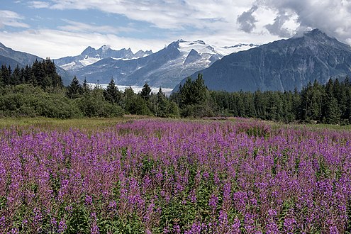
 Left to right: McGinnis Mountain, Stroller White Mountain, Mendenhall Glacier, and Bullard


External links[edit]
- Weather forecast: Bullard Mountain
- Bullard Mountain climbing blog with photos
- Nugget Towers and Bullard Mountain: Flickr photo