
Brécy, Aisne
You can help expand this article with text translated from the corresponding article in French. (December 2008) Click [show] for important translation instructions.
|
Brécy | |
|---|---|
 The church of Brécy | |
Location of Brécy  | |
 Brécy  Brécy | |
| Coordinates: 49°08′55″N 3°25′49″E / 49.1486°N 3.4303°E | |
| Country | France |
| Region | Hauts-de-France |
| Department | Aisne |
| Arrondissement | Château-Thierry |
| Canton | Château-Thierry |
| Intercommunality | CA Région de Château-Thierry |
| Government | |
| • Mayor (2020–2026) | Vincent Varnier[1] |
| Area 1 | 9.98 km2 (3.85 sq mi) |
| Population (2021)[2] | 319 |
| • Density | 32/km2 (83/sq mi) |
| Time zone | UTC+01:00 (CET) |
| • Summer (DST) | UTC+02:00 (CEST) |
| INSEE/Postal code | 02119 /02210 |
| Elevation | 103–216 m (338–709 ft) (avg. 130 m or 430 ft) |
| 1 French Land Register data, which excludes lakes, ponds, glaciers > 1 km2 (0.386 sq mi or 247 acres) and river estuaries. | |
Brécy (French pronunciation: [bʁesi]) is a commune in the department of Aisne in Hauts-de-France in northern France.
Points of Interest[edit]
- Saint-Michel Church from the 12th century, Monument historique sience 1920
- The castle of Le Buisson from the 13th century, Monument historique siece 1981
- Engraved rock from the 5th century, Monument historique sience 1975 (Rocher gravé de Brécy
-
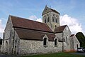 Saint Michel Church
 -
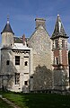 Castle of Le Buisson
 -
 Engraved Rock


Population[edit]
| Year | Pop. | ±% |
|---|---|---|
| 1962 | 201 | — |
| 1968 | 215 | +7.0% |
| 1975 | 224 | +4.2% |
| 1982 | 183 | −18.3% |
| 1990 | 284 | +55.2% |
| 1999 | 318 | +12.0% |
| 2008 | 342 | +7.5% |
See also[edit]
References[edit]
- ^ "Répertoire national des élus: les maires". data.gouv.fr, Plateforme ouverte des données publiques françaises (in French). 9 August 2021.
- ^ "Populations légales 2021". The National Institute of Statistics and Economic Studies. 28 December 2023.
Wikimedia Commons has media related to Brécy (Aisne).
This Château-Thierry arrondissement geographical article is a stub. You can help Wikipedia by expanding it. |