
Boreas Mountain (Colorado)
| Boreas Mountain | |
|---|---|
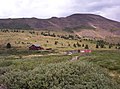
 North aspect | |
| Highest point | |
| Elevation | 13,082 ft (3,987 m)[1][2] |
| Prominence | 916 ft (279 m)[3] |
| Parent peak | Bald Mountain (13,690 ft)[3] |
| Isolation | 2.88 mi (4.63 km)[3] |
| Coordinates | 39°24′22″N 105°56′55″W / 39.4061136°N 105.9486366°W[4] |
| Naming | |
| Etymology | Boreas, Boreas Pass |
| Geography | |
 Boreas Mountain Location in Colorado  Boreas Mountain Boreas Mountain (the United States) | |
| Country | United States |
| State | Colorado |
| County | Park |
| Protected area | Pike National Forest[3] |
| Parent range | Rocky Mountains Front Range[1] |
| Topo map | USGS Boreas Pass |
| Climbing | |
| Easiest route | Hiking class 2[3] |
Boreas Mountain is a 13,082-foot (3,987 m) mountain summit in Park County, Colorado, United States.
Description[edit]
Boreas Mountain is set one-half mile east of the Continental Divide in the Front Range, which is a subrange of the Rocky Mountains. The mountain is located seven miles (11 km) southeast of the community of Breckenridge and one mile (1.6 km) east-southeast of Boreas Pass, on land managed by Pike National Forest. Precipitation runoff from the mountain's slopes drains into tributaries of Tarryall Creek which flows to the South Platte River. Topographic relief is modest as the summit rises over 2,000 feet (610 m) in one mile (1.6 km). The mountain's toponym has been officially adopted by the United States Board on Geographic Names.[4] The mountain is named in association with Boreas Pass, which takes its name from Boreas, the Greek god of the cold north wind.[5] Sidney Dillon applied the Boreas name to the pass.[6]
Climate[edit]
According to the Köppen climate classification system, Boreas Mountain is located in an alpine subarctic climate zone with cold, snowy winters, and cool to warm summers.[7] Due to its altitude, it receives precipitation all year, as snow in winter and as thunderstorms in summer, with a dry period in late spring.
See also[edit]
Gallery[edit]
-
 West aspect of Boreas Mountain from Boreas Pass
 -
 South aspect of Boreas Mountain viewed from Boreas Pass Road
 -
 South aspect of Boreas Mountain viewed from Boreas Pass Road
 -
 West aspect of Boreas Mountain from Boreas Pass


References[edit]
- ^ a b "Boreas Mountain, Colorado". Peakbagger.com. Retrieved May 6, 2023.
- ^ Stewart M. Green (2013), Scenic Routes & Byways: Colorado, Globe Pequot, ISBN 9780762795888, p. 126.
- ^ a b c d e "Boreas Mountain - 13,083' CO". listsofjohn.com. Retrieved May 6, 2023.
- ^ a b "Boreas Mountain". Geographic Names Information System. United States Geological Survey, United States Department of the Interior. Retrieved May 6, 2023.
- ^ Maxine Benson (1994), 1001 Colorado Place Names, University Press of Kansas, ISBN 9780700606320, p. 22.
- ^ Jim Flynn (2016), A Compendium of Curious Colorado Place Names, Arcadia Publishing Incorporated, ISBN 9781439658734
- ^ Peel, M. C.; Finlayson, B. L.; McMahon, T. A. (2007). "Updated world map of the Köppen−Geiger climate classification". Hydrol. Earth Syst. Sci. 11. ISSN 1027-5606.
External links[edit]
- Boreas Mountain: weather forecast