Bideford Railway Heritage Centre
This article needs additional citations for verification. (October 2009) |
| Bideford Railway Heritage Centre | |
|---|---|
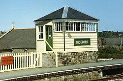
 A replica of the original signal box at Bideford Railway Station | |
| Commercial operations | |
| Built by | London and South Western Railway |
| Original gauge | 4 ft 8+1⁄2 in (1,435 mm) standard gauge |
| Preserved operations | |
| Stations | 1 |
| Preserved gauge | 4 ft 8+1⁄2 in (1,435 mm) standard gauge |
| Commercial history | |
| Opened | 2 November 1855 |
| Closed | 6 November 1982 |
| Preservation history | |
| 1988 | Society formed |
| Headquarters | Bideford, Devon |
| Website | |
| www | |
The Bideford Railway Heritage Centre CIC (previously the Bideford and Instow Railway Group) in Devon, England is a community interest company that is responsible for the management of the site of Bideford railway station. The company is also responsible for Instow signal box which opens on occasional Sundays and bank holidays from Easter to October.[1]
History[edit]

The line was opened from Barnstaple to Fremington in 1848. Passenger trains ran throughout from Barnstaple railway station to Bideford from 2 November 1855 as the Bideford Extension Railway. The line was further extended to Torrington in 1872 when the current Bideford railway station was opened.
Passenger services ceased on 2 October 1965 although ball clay traffic continued until 1982. The track was removed in 1985 after some interest by British Rail in reintroducing a passenger service to Bideford.[2] The trackbed was later converted into the Tarka Trail, a walkway using the formation between Petrockstow (later the terminus of services after the line was truncated in the 1960s) and Barnstaple Junction.
In 2009, James May attempted to reconnect the former Bideford station with Barnstaple Junction using an OO scale model train as part of James May's Toy Stories. Unfortunately, the last train - a Hornby Class 395 "Javelin", and the prototype model for the production models - burnt out at Instow at 12:18am the day after the trains left Barnstaple.[3] In 2011, May returned to complete the challenge with the help of the German model railway attraction Miniatur Wonderland, racing several model trains over the 9.89 miles (15.92 km) from Barnstaple to Bideford. The first train to arrive at Bideford was a Hornby Intercity 125, followed by a hydrogen-powered train and finally, May's own model of LNER 'Pacific' 4472 Flying Scotsman.[4]
Visitor attractions[edit]
Barnstaple to Halwill Junction | ||||||||||||||||||||||||||||||||||||||||||||||||||||||||||||||||||||||||||||||||||||||||||||||||||||||||||||||||||||||||||||||||||||||||||||||||||||||||||||||||||||||||||||||||||||||||
|---|---|---|---|---|---|---|---|---|---|---|---|---|---|---|---|---|---|---|---|---|---|---|---|---|---|---|---|---|---|---|---|---|---|---|---|---|---|---|---|---|---|---|---|---|---|---|---|---|---|---|---|---|---|---|---|---|---|---|---|---|---|---|---|---|---|---|---|---|---|---|---|---|---|---|---|---|---|---|---|---|---|---|---|---|---|---|---|---|---|---|---|---|---|---|---|---|---|---|---|---|---|---|---|---|---|---|---|---|---|---|---|---|---|---|---|---|---|---|---|---|---|---|---|---|---|---|---|---|---|---|---|---|---|---|---|---|---|---|---|---|---|---|---|---|---|---|---|---|---|---|---|---|---|---|---|---|---|---|---|---|---|---|---|---|---|---|---|---|---|---|---|---|---|---|---|---|---|---|---|---|---|---|---|---|
| ||||||||||||||||||||||||||||||||||||||||||||||||||||||||||||||||||||||||||||||||||||||||||||||||||||||||||||||||||||||||||||||||||||||||||||||||||||||||||||||||||||||||||||||||||||||||
The Bideford Railway Heritage Centre has developed the site since 1989 to ensure a preservation presence at the old Bideford station. A replica of the original signal box was built in 1992 and signal levers were installed later. An interactive interpretation centre was opened in the green PMV (Parcels and Miscellaneous Van) in 2019. Short passenger rides are given at Bideford on dates announced on the website www.bidefordrailway.co.uk, using the Planet diesel locomotive. The site has been fully renovated and is open from Easter to the end of October at weekends and school holidays. A cafe in the Mark 1 coach at these times for walkers and cyclists on the Tarka Trail. The site is accessible from the Tarka Trail even when the station site is not open.
Rolling stock[edit]
The Railway has the following items of rolling stock.
- Hibberd Planet diesel locomotive No.3832, operational.[5]
- BR Mk1 TSO 4489, Used as a cafe and is painted in BR Green.[6]
- SR PMV 2142, Holds the Interactive Interpretation Centre.[7]
- BR Toadfit brake van Under overhaul.
See also[edit]
- Other local railway attractions:
References[edit]
- ^ "Instow". BIDEFORD RAILWAY HERITAGE CENTRE.
- ^ "Line History". BIDEFORD RAILWAY HERITAGE CENTRE.
- ^ "Hornby". BBC.
- ^ "The Great Train Race". BBC.
- ^ "No.3832: Planet 0-4-0 Diesel Locomotive". BIDEFORD RAILWAY HERITAGE CENTRE.
- ^ "BR 4489 Mk 1 Tourist Second Open built 1956". VCT.
- ^ "SR 2142 Four-wheel PMVY (Parcels & Miscellaneous Van) built 1942". VCT.
External links[edit]
- Official website

- Bideford Railway Museum – Information from Devon County Council
- Entry at Information Britain
- Video footage of the museum
