
Beaverbrook, Connecticut
Beaverbrook, Connecticut | |
|---|---|
Unincorporated area | |
Beaverbrook Chapel | |
 Beaverbrook Location in Connecticut  Beaverbrook Location in the United States | |
| Coordinates: 41°24′40.34″N 73°25′11.44″W / 41.4112056°N 73.4198444°W[1] | |
| Country | |
| U.S. state | |
| County | Fairfield |
| Region | Western CT |
| City | Danbury |
| Major highways | |

Beaverbrook or Beaver Brook, is an unincorporated area in the City of Danbury, Fairfield County, Connecticut.[1]
History[edit]

The area is named after the stream, which flows north out of East Swamp in Bethel and connects with the Still River in East Danbury. References to Beaver Brook can be found from as far back as 1743, although many maps identify Beaver Brook as Limekiln Brook or East Swamp Brook.[2]
Upstream, north of the confluence, is Beaver Brook Mountain, which extends from Danbury into Brookfield.[3] The mountain was considered part of Danbury's Beaver Brook district until Brookfield was incorporated from Danbury in 1788.[4] Despite the official incorporation, this particular area would still be recognized as Beaver Brook for years to come. Notably, the White Turkey Inn, which was established 28 years prior to Brookfield's incorporation,[5] would continue to advertise as a Danbury locale.[6]
Industry[edit]
1790 marks the start of Beaverbrook's industrial timeline, with the construction of the Beaver Brook paper manufacturing mill, which would later become the McArthur paper mill.[7]: 120 Another noteworthy operation in Beaverbrook was the E. Sturdevant wool hat factory, which operated until it was destroyed by fire on August 31, 1873.[7]: 235
To this day the area is considered a heavily industrial area.
-
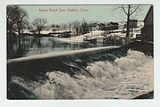 Beaver Brook paper mill dam
 -
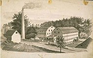 Studevant Hat Factory


Geography[edit]
Beaverbrook borders the Stony Hill & Plumtrees sections of Bethel, the Beaver Brook Mountain section of Brookfield, as well as the Danbury neighborhoods of Great Plain, Germantown, and Shelter Rock.
Construction of I-84[edit]
Construction of the "Yankee Expressway" in Danbury divided the neighborhood, isolating the northernmost section of Beaverbrook (now Old Brookfield Rd. and the Danbury portion of Federal Rd. North).[8] The project resulted in hundreds of displaced families.[9]
Sites of interest[edit]

- John Oliver Memorial Sewer Plant
- Still River Greenway
References[edit]
- ^ a b "Beaverbrook". Geographic Names Information System. United States Geological Survey, United States Department of the Interior.
- ^ Imogene Heireth (1985). Names-Places: How Danbury Got Some Unusual Ones (PDF). Danbury: Danbury Tricentennial Committee. p. 6. Retrieved January 8, 2022.
- ^ State of Connecticut (1915). State Geological and Natural History Survey of Connecticut. Hartford, Connecticut: Connecticut Board of Control. p. 34. Retrieved January 15, 2023.
- ^ "CONNECTICUT TOWNS IN THE ORDER OF THEIR ESTABLISHMENT; WITH THE ORIGIN OF THEIR NAMES". Office of the Secretary of the State Secretary of the State. Retrieved January 15, 2023.
- ^ Tercentenary Commission of the State of Connecticut. Danbury Committee (1935). The Connecticut Tercentenary, 1635–1935, and the two hundred and fiftieth anniversary of the settlement of the town of Danbury which included the Society of Bethel, 1635–1935. New Haven: Yale University Press. p. 22. Retrieved January 15, 2023.
- ^ "The White Turkey, Beaver Brook Mountain, Danbury, Conn". 1900. Retrieved January 15, 2023.
- ^ a b Bailey, James M. (1896). History of Danbury, Conn., 1684–1896.
- ^ "Change Urged in Interchange". The Bridgeport Post. Bridgeport, Connecticut. April 9, 1958. Retrieved January 16, 2023.
- ^ Lauf, Robert (August 5, 1957). "Plans Advanced for Route 6 Job". The Bridgeport Post. Bridgeport, Connecticut. Retrieved January 16, 2023.
| Landmarks |
|  | ||
|---|---|---|---|---|
| Neighborhoods |
| |||
| Government | ||||
| Education | ||||
| Transportation | ||||
| Sports teams | ||||