
Aperture Peak
| Aperture Peak | |
|---|---|
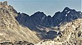
 West aspect | |
| Highest point | |
| Elevation | 13,265 ft (4,043 m)[1][2] |
| Prominence | 305 ft (93 m)[3] |
| Parent peak | Mount Agassiz (13,899 ft)[4] |
| Isolation | 0.44 mi (0.71 km)[4] |
| Coordinates | 37°07′05″N 118°31′50″W / 37.1180306°N 118.5304725°W[5] |
| Geography | |
 Aperture Peak Location in California  Aperture Peak Aperture Peak (the United States) | |
| Location | Inyo County, California, U.S. |
| Parent range | Sierra Nevada Inconsolable Range[3] |
| Topo map | USGS North Palisade |
| Geology | |
| Age of rock | Cretaceous |
| Mountain type | Fault block |
| Type of rock | Inconsolable Quartz Monzodiorite[6] |
| Climbing | |
| First ascent | 1934 |
| Easiest route | class 3 via Jigsaw Pass[2] |
Aperture Peak is a 13,265-foot-elevation (4,043 meter) mountain summit located in Inyo County, California, United States.[5]
Description[edit]
Aperture Peak is set within the John Muir Wilderness, on land managed by Inyo National Forest. It is situated one-half mile east of the crest of the Sierra Nevada mountain range in the Palisades area, just outside the boundary of Kings Canyon National Park. It is approximately 14 miles (23 km) west of the community of Big Pine, one mile (1.6 km) east-northeast of Bishop Pass, one-half mile (0.80 km) north of line parent Mount Agassiz, and 0.8 miles (1.3 km) southeast of Picture Puzzle. Aperture Peak ranks as the 95th-highest summit in California,[4] and the fourth-highest peak of the Inconsolable Range.[3] Topographic relief is modest as the summit rises 2,500 feet (760 meters) above the Big Pine Lakes in 1.5 mile. The west face of the peak features a large, white, diagonal dike, and a rock glacier lies below the east face.
History[edit]
The first ascent of the summit was made June 14, 1934, by David Brower and Hervey Voge.[2] This landform's toponym was officially adopted in 1969 by the U.S. Board on Geographic Names,[5] but the name was used informally by mountaineers for years prior.[7] The geological term "aperture" is the measure of the distance separating adjacent rock walls relating to joints and open discontinuities.
Climate[edit]
According to the Köppen climate classification system, Aperture Peak is located in an alpine climate zone.[8] Most weather fronts originate in the Pacific Ocean, and travel east toward the Sierra Nevada mountains. As fronts approach, they are forced upward by the peaks (orographic lift), causing them to drop their moisture in the form of rain or snowfall onto the range. Precipitation runoff from this mountain drains east into headwaters of North Fork Big Pine Creek, and west into headwaters of South Fork Bishop Creek.
Gallery[edit]
-
 Aperture Peak (left) and Mount Agassiz from Bishop Lake
 -
 Picture Puzzle (left) and Aperture Peak (right) from Bishop Pass
 -
 Aperture Peak (left) and Mount Agassiz from Bishop Lake
 -
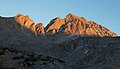
 Sunset on Aperture Peak (left) and Mt. Agassiz, from Bishop Lake
 -
 Picture Puzzle (left), Aperture Peak centered, and Mt. Agassiz (right)
 -
 Dawn view of Aperture Peak (left) and Mt. Agassiz (right)
 -
 Sunset on Aperture Peak (left) and Mt. Agassiz


See also[edit]
References[edit]
- ^ United States Geological Survey topographical map - North Palisade
- ^ a b c Secor, R.J. (2009). The High Sierra Peaks, Passes, and Trails (3rd ed.). Seattle: The Mountaineers. p. 263. ISBN 978-0898869712.
- ^ a b c "Aperture Peak, California". Peakbagger.com. Retrieved 2022-07-22.
- ^ a b c "Aperture Peak CA". ListsOfJohn.com. Retrieved 2022-07-22.
- ^ a b c "Aperture Peak". Geographic Names Information System. United States Geological Survey, United States Department of the Interior. Retrieved 2022-07-22.
- ^ Stratotype Inventory—Sequoia and Kings Canyon National Parks, California, nps.gov
- ^ Browning, Peter (1986). Place Names of the Sierra Nevada. Berkley: Wilderness Press. p. 6. ISBN 978-0899970479.
- ^ "Climate of the Sierra Nevada". Encyclopædia Britannica.
External links[edit]
- Weather forecast: Aperture Peak
Places adjacent to Aperture Peak | ||||||||||||||||
|---|---|---|---|---|---|---|---|---|---|---|---|---|---|---|---|---|
| ||||||||||||||||