
Abernathy, Alabama
Abernathy, Alabama | |
|---|---|
 Abernathy, Alabama  Abernathy, Alabama | |
| Coordinates: 33°39′02″N 85°24′27″W / 33.65056°N 85.40750°W | |
| Country | United States |
| State | Alabama |
| County | Cleburne |
| Elevation | 1,024 ft (312 m) |
| Time zone | UTC-6 (Central (CST)) |
| • Summer (DST) | UTC-5 (CDT) |
| Area code | 256 |
| GNIS feature ID | 155975[1] |
Abernathy is an unincorporated community in Cleburne County, Alabama, United States[1][2]
Demographics[edit]
Abernathy Precinct (1880-1950)[edit]
Abernathy village has never reported a population figure separately on the U.S. Census as an unincorporated community. However, the 8th beat/precinct of Cleburne County bore its name from 1880 to 1950.[3] In the 1930[4] and 1940[5] returns, when the census recorded racial statistics for the precincts, both times reported a White majority for the precinct. In 1960, the precincts were merged and/or reorganized into census divisions (as part of a general reorganization of counties) and it was consolidated into the census division of Ranburne.[6]
| Census | Pop. | Note | %± |
|---|---|---|---|
| 1880 | 1,126 | — | |
| 1890 | 1,364 | 21.1% | |
| 1900 | 1,348 | −1.2% | |
| 1910 | 1,421 | 5.4% | |
| 1920 | 1,683 | 18.4% | |
| 1930 | 1,422 | −15.5% | |
| 1940 | 1,564 | 10.0% | |
| 1950 | 1,144 | −26.9% | |
| U.S. Decennial Census[7] | |||
References[edit]
- ^ a b "Anernathy, Alabama". Geographic Names Information System. United States Geological Survey, United States Department of the Interior.
- ^ "Alabama Maps-Cleburne County" (PDF). Retrieved March 31, 2023.[permanent dead link]
- ^ Census data 1880s census.gov
- ^ Census data census.gov
- ^ Census data census.gov
- ^ Census data census.gov
- ^ "U.S. Decennial Census". Census.gov. Retrieved June 6, 2013.
Municipalities and communities of Cleburne County, Alabama, United States | ||
|---|---|---|
| City | 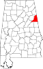 | |
| Towns | ||
| CDP | ||
| Unincorporated communities | ||
This Cleburne County, Alabama state location article is a stub. You can help Wikipedia by expanding it. |