
User:Eevee2425/sandbox
Brading | |||||
|---|---|---|---|---|---|
 | |||||
| General information | |||||
| Location | Brading, Isle of Wight England | ||||
| Coordinates | 50°40′41″N 1°08′20″W / 50.678°N 1.139°W | ||||
| Grid reference | SZ609868 | ||||
| Managed by | Island Line Trains | ||||
| Platforms | 1 | ||||
| Other information | |||||
| Station code | BDN | ||||
| Classification | DfT category F2 | ||||
| History | |||||
| Opened | 23 August 1864 | ||||
| Passengers | |||||
| 2014/15 | |||||
| 2015/16 | |||||
| |||||

Brading railway station is a railway station serving Brading on the Isle of Wight. It is located on the Island Line from Ryde to Shanklin.
History[edit]
The station was opened in 1864 by the Isle of Wight Railway on the Ryde-Shanklin-Ventnor line. In 1882 it became a junction station, when the Brading-Bembridge branch line as part of the Brading Haven reclamation scheme. The branch line closed to passengers in 1953 and completely in 1957.
Under Southern Railway ownership, the passing loop was extended southwards from Brading to Sandown in 1927, forming a second section of double track on the Island Line.[1]
By the early 1980s Brading was one of the last stations on British Rail to retain gas lighting. In 1985 this changed; although the fittings were retained, they were converted from gas to mercury vapour usage. A few survive in 2010, now using compact fluorescent bulbs.
Brading signalbox closed on 28 October 1988. At this time, the passing loop at Brading station was removed, meaning that only one platform remained in use. This meant the end of 30-minute interval service on the line for over 25 years.[2] By 1998 the signal box and branch platforms were very overgrown and the buildings were threatened with demolition. Brading Town Council stepped in and with the help of grants and volunteers, from 2002, different parts of the station were gradually being reopened, on March 2010 the whole of the station and signal box was fully opened to the public for the first time in 40 years. The restored signal box and station buildings are now home to a heritage centre, cafe, museum and a Tourist Information Point.[3]
Facilities[edit]
In August 2007 Brading Town Council announced a plan to revamp the exterior of the station buildings and former signal box.[4] The station building houses a café, visitors' centre and bike hire shop. There is no railway staff presence at the station, tickets are issued from an automatic machine or from the guard on board the train. Trains for both directions leave from the same platform, as the line is presently single track.
In an online discussion, South West Trains' Managing Director Stewart Palmer stated that the company hoped Network Rail might reinstate the passing loop at Brading station by the middle of 2014, although the exact timescale depends on the line's resignalling.[5]
| Preceding station | Following station | |||
|---|---|---|---|---|
| Sandown | Island Line Trains Island Line |
Smallbrook Junction | ||
| Disused railways | ||||
| Terminus | British Rail Southern Region IoWR :Bembridge branch |
St Helens | ||
Gallery[edit]
-
 The exterior of Brading station.
 -
 Brading Station.
 -
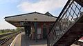 Platform 1.
 -
 Island Platform, formerly 2 and 3.
 -
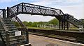 Footbridge.
 -
 Signal Box.
 -
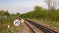 Looking Northbound towards Ryde.
 -
 Looking Southbound towards Sandown.


References[edit]
- ^ Hardy, Brian (2003). Tube Trains on the Isle of Wight. Harrow Weald, Middlesex: Capital Transport. p. 9. ISBN 1-85414-276-3.
- ^ Hardy, Brian (2003). Tube Trains on the Isle of Wight. Harrow Weald, Middlesex: Capital Transport. p. 37. ISBN 1-85414-276-3.
- ^ "Brading Station Visitor Centre". Retrieved 4 April 2017.
- ^ The News, Portsmouth, 3 August 2007
- ^ "South West Trains: Performance". 17 February 2009. Retrieved 17 February 2009. Question 112
External links[edit]
- Train times and station information for Eevee2425/sandbox from National Rail
Category:Railway stations on the Isle of Wight Category:Former Isle of Wight Railway stations Category:Railway stations opened in 1864 Category:Railway stations served by South West Trains