
Trelissick
| Trelissick | |
|---|---|
 View of the south front | |
 Location of Trelissick in Cornwall | |
| General information | |
| Type | Manor House |
| Town or city | Feock, Cornwall |
| Country | England |
| Inaugurated | c. 1750 |
| Owner | National Trust |
| Designations | |
Listed Building – Grade II* | |
| Official name | Trelissick House and walls surrounding |
| Designated | 28 February 1952 |
| Reference no. | 1159398 |
Trelissick (Cornish: Trelesyk) is a house and garden in the ownership of the National Trust at Feock, near Truro, Cornwall, England. It is located on the B3289 road, just west of King Harry Ferry, and overlooks the estuary known as Carrick Roads. It lies within the Cornwall Area of Outstanding Natural Beauty (AONB). Almost a third of Cornwall has AONB designation.
It receives over 200,000 visitors annually.[1]
History[edit]

Trelissick, first recorded in 1275, means Leidic's farm.[2] Trelissick in the parish of St Ewe has the same derivation but Trelissick in St Erth and Trelissick in Sithney have a different one ("Gwledic's farm").[3]
The house was designed around 1750 by the paternal grandfather of Humphry Davy for John Lawrence and remodelled in the 1820s by Thomas Daniell. It was further extended in the late 19th century. It is Grade 2* listed.[4]
The estate has been in the ownership of the National Trust since 1955 when it was donated by Ida Copeland following the death of her son Geoffrey. A stained glass memorial bearing the Copeland coat of arms was donated to Feock parish church by Mrs. Copeland. The house and garden had formerly been owned and developed by the Daniell family, which had made its fortune in the 18th century Cornish copper mining industry.[citation needed]
The contents of the house were sold in July 2013 by Bonhams auctioneers.[5]
Cornish wrestling[edit]
Cornish wrestling tournaments, for prizes, were held in Trelissick in the 1900s.[6]
Garden[edit]
Many of the species that flourish in the mild Cornish air, including the rhododendrons and azaleas which are now such a feature of the garden, were planted by the Copelands including hydrangeas, camellias and flowering cherries, and exotics such as the ginkgo and various species of palm. They also ensured that the blossoms they nurtured had a wider, if unknowing audience. Mr Ronald Copeland was chairman and later managing director of his family's business, the Spode china factory. Flowers grown at Trelissick were used as models for those painted on ware produced at the works.
The Copeland family crest, a horse's head, now decorates the weathervane on the turret of the stable block, making a pair with the Gilbert squirrels on the Victorian Gothic water tower, an echo of the family who lived here in the second half of the 19th century (their ancestor, Sir Humphrey Gilbert, was lost at sea in his ship Squirrel after discovering Newfoundland).
The garden is noted for its rare shrubs. It offers a large park, woodland walks, views over the estuary of the River Fal and Falmouth.
Special plants[edit]
Trelissick Garden is the home of the National Plant Collections of photinias and azaras.
Gallery[edit]
-
 Trelissick view
 -
 Trelissick view
 -
 Trelissick view
 -
 Trelissick view
 -
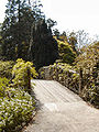 Bridge between the two parts of the garden
 -
 Chinese cedar
 -
 Chinese cedar
 -
 Yucca blossom


References[edit]
- ^ "ALVA - Association of Leading Visitor Attractions". www.alva.org.uk. Retrieved 9 November 2020.
- ^ Craig Weatherhill (2009) A Concise Dictionary of Cornish Place-Names. Westport, Co. Mayo: Evertype ISBN 978-1-904808-22-0; p. 72)
- ^ Weatherhill (2009); p. 72
- ^ Historic England. "Trelissick House and walls surrounding (1159398)". National Heritage List for England. Retrieved 14 September 2019.
- ^ "Bonhams : The Contents of Trelissick House including the Copeland China Collection".
- ^ West Briton and Cornwall Advertiser - Thursday 21 July 1994.
- "Trelissick" in Feock with Devoran and Carnon Down in the 19th Century (Part 2) by the Feock Local History Group (1973) Republished 2006 (pp. 39–50)
- National Trust Guide; October 1996
External links[edit]
| Authority control databases: Geographic |
|---|