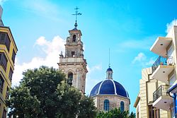
Sueca, Spain
This article needs additional citations for verification. (October 2024) |
Sueca | |
|---|---|
 | |
| Coordinates: 39°12′0″N 0°18′41″W / 39.20000°N 0.31139°W | |
| Country | |
| Autonomous community | |
| Province | Valencia |
| Comarca | Ribera Baixa |
| Judicial district | Sueca |
| Government | |
| • Alcalde | Roger Tamarit (2015) (Compromís) |
| Area | |
| • Total | 92.5 km2 (35.7 sq mi) |
| Elevation | 3 m (10 ft) |
| Population (2018)[1] | |
| • Total | 27,460 |
| • Density | 300/km2 (770/sq mi) |
| Demonym(s) | Suecà, Suecana |
| Time zone | UTC+1 (CET) |
| • Summer (DST) | UTC+2 (CEST) |
| Postal code | 46410 |
| Official language(s) | Spanish and Valencian |
| Website | Official website |
Sueca (Valencian: [suˈɛka]; Spanish: [ˈsweka] ) is a city in eastern Spain in the Valencian Community. It is situated on the left bank of the river Xúquer. The town of Sueca is separated from the Mediterranean Sea 11 kilometres (7 miles) to the east by the Serra de Cullera, though the municipality possesses 7 km (4 mi) of Mediterranean coastline. Some of the architecture shows Moorish roots—the flat roofs, view-turrets (miradors), and horseshoe arches—and the area has an irrigation system dating from Moorish times. Rice processing is the principal industry, though oranges are also exported.
Villages included in the municipality
[edit]Twin Towns
[edit]References
[edit]- ^ Municipal Register of Spain 2018. National Statistics Institute.
External links
[edit]This article incorporates text from a publication now in the public domain: Chisholm, Hugh, ed. (1911). "Sueca". Encyclopædia Britannica. Vol. 26 (11th ed.). Cambridge University Press. p. 21.


