Sainte-Anne River (Beaupré): Difference between revisions
Add tributaries |
|||
| Line 50: | Line 50: | ||
| river_system = |
| river_system = |
||
| basin_size = {{convert|1077|km2|abbr=on}} |
| basin_size = {{convert|1077|km2|abbr=on}} |
||
| tributaries_left =(upward from the mouth) [[rivière des Chenaux]], ruisseau Clair, Le Big Creek, décharge des lacs Auguste et Eugène, ruisseau Noir, décharge d'un ensemble de lacs dont lac du Lièvre, lac Bouchard lac Croche et lac à l'Ours, décharge du lac Thibault... |
|||
| tributaries_left = |
|||
| tributaries_right =(upward from the mouth) [[rivière du Mont Saint-Étienne]], [[rivière Brûlée (rivière Sainte-Anne)]], ruisseau Beaumier, ruisseau Laliberté, décharge du lac Saint-Louis, décharge d'un ensemble de lacs dont Lac de la Ligne de Comté, lac du Nord-Est et lac Henri-Béique, [[rivière Savane-du-Nord]]... |
|||
| tributaries_right = |
|||
| custom_label = |
| custom_label = |
||
| custom_data = |
| custom_data = |
||
Revision as of 13:47, 21 January 2020
| Sainte-Anne River Rivière Sainte-Anne-du-Nord | |
|---|---|
 Sainte-Anne (Beaupré) River | |
| Location | |
| Country | Canada |
| Province | Quebec |
| Region | Capitale-Nationale |
| Regional County Municipality | La Côte-de-Beaupré Regional County Municipality |
| Physical characteristics | |
| Source | Lac Sainte-Anne-du-Nord |
| • location | Lac-Pikauba |
| • coordinates | 47°41′08″N 70°44′11″W / 47.685499°N 70.736332°W |
| • elevation | 914 m (2,999 ft) |
| Mouth | Saint Lawrence River |
• location | Beaupré, MRC La Côte-de-Beaupré Regional County Municipality |
• coordinates | 47°02′24″N 70°53′00″W / 47.040051°N 70.883446°W |
• elevation | 6 m (20 ft) |
| Length | 97 km (60 mi) |
| Basin size | 1,077 km2 (416 sq mi) |
| Basin features | |
| Tributaries | |
| • left | (upward from the mouth) rivière des Chenaux, ruisseau Clair, Le Big Creek, décharge des lacs Auguste et Eugène, ruisseau Noir, décharge d'un ensemble de lacs dont lac du Lièvre, lac Bouchard lac Croche et lac à l'Ours, décharge du lac Thibault... |
| • right | (upward from the mouth) rivière du Mont Saint-Étienne, rivière Brûlée (rivière Sainte-Anne), ruisseau Beaumier, ruisseau Laliberté, décharge du lac Saint-Louis, décharge d'un ensemble de lacs dont Lac de la Ligne de Comté, lac du Nord-Est et lac Henri-Béique, rivière Savane-du-Nord... |

Ste-Anne-du-Nord River is a river in Capitale-Nationale, Quebec, Canada. The river passes through Canyon Sainte-Anne before joining the Saint Lawrence River at Beaupré.
Geography
Rivière Sainte-Anne is a river in the Capitale-Nationale region. It has a length of 97 km, covers a basin of
| Expression error: Unrecognized word "sainte". | |
|---|---|
Expression error: Unrecognized word "sainte". Expression error: Unrecognized word "sainte". | |
| Cardinal | Lua error in Module:ConvertNumeric at line 576: Invalid decimal numeral. |
| Ordinal | Sainte-Anne Riverth (Lua error in Module:ConvertNumeric at line 576: Invalid decimal numeral.) |
| Factorization | Expression error: Unrecognized word "sainte". |
| Greek numeral | Expression error: Unrecognized word "sainte". |
| Roman numeral | Expression error: Unrecognized word "sainte". |
| Binary | Expression error: Unrecognized word "sainte". |
| Ternary | Expression error: Unrecognized word "sainte". |
| Senary | Expression error: Unrecognized word "sainte". |
| Octal | Expression error: Unrecognized word "sainte". |
| Duodecimal | Expression error: Unrecognized word "sainte". |
| Hexadecimal | Expression error: Unrecognized word "sainte". |
and has an average flow of 26 m3/s. The river finds its source at Lac Sainte-Anne-du-Nord. From there, it flows south and ends at Beaupré, opposite Île d'Orléans, 35 km northeast of the city of Quebec in the St. Lawrence River[1].
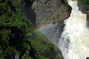
In Saint-Ferréol-les-Neiges are the Seven Chutes, falls which in many cases are 128 m high[2]. Then the river crosses the Canyon Sainte-Anne, a gorge with a length of 10 km. At its end, in Saint-Joachim is the Sainte-Anne waterfall, 74 m high.
Toponymy
The toponym "Rivière Sainte-Anne" was formalized on April 4, 1982 at the Place Names Bank of the Commission de toponymie du Québec[3]
Sept-Chutes hydroelectric plant
The Sept-Chutes power plant, a hydroelectric power plant run-of-the-water power plant belonging to Hydro-Québec is on the Sainte-Anne river. It was built in 1916 and modernized in 1999. It has 4 turbines for a total output of 22 MW. The hydraulic potential amounts to 124.97 m. The power station can be visited[4].
 |
Hydro-Canyon hydroelectric plant
It was in 2016 that the hydroelectric power station of Société Hydro-Canyon Saint-Joachim started up a hydroelectric power station over water 300 meters upstream from Canyon Sainte-Anne.
The Hydro-Canyon Saint-Joachim run-of-river power plant project was designed taking into account the technical and environmental aspects of the integration environment.
The development will harmonize with the recreotourism facilities of Canyon Sainte-Anne.
The works will optimize the site on the hydroelectric level while developing the potential of the Sainte-Anne waterfall. The maximum power of the plant will be 23.2 MW.
The installation will include:
- A weir threshold to maintain the upstream level of the river
- A spillway
- A water intake
- An entrance gallery
- A power plant including production equipment
- A substation and a power line connecting the site to the Hydro-Québec network
Sport

The Sainte-Anne-du-Nord river has also been used since 1966 by a club and a river kayak school. First bearing the name of Club Echohamok, it has evolved to bear today the name of Côte-de-Beaupré. It must be said that the Sainte-Anne-du-Nord river has a portion of river located between the Sept-Chutes hydroelectric plant and the Hydro-Canyon hydroelectric plant which is classified 5 stars by the guide of rivers of Quebec.
