
Sutter Buttes: Difference between revisions
m Bot: link syntax and minor changes |
Rescuing 1 sources and tagging 0 as dead. #IABot (v1.6.1) (Balon Greyjoy) |
||
| Line 41: | Line 41: | ||
The Sutter Buttes lie within the [[Central Valley (California)|Great Valley of California]].<ref name=CGPNote36/> |
The Sutter Buttes lie within the [[Central Valley (California)|Great Valley of California]].<ref name=CGPNote36/> |
||
They were formed about 1.6 million years ago in the early [[Pliocene]] Epoch<ref name=CGPNote36>[http://www.conservation.ca.gov/cgs/information/publications/cgs_notes/note_36/Documents/note_36.pdf State of California, ‘’California Geologic Provinces,’’ Note 36, page 2]</ref> by [[volcano|volcanic activity]]. They are the remnants of a volcano that has been dormant<ref>{{cite web |url=http://www.syix.com/yubacity/sutterbuttes.html |title=Yuba City's Sutter Buttes |accessdate=2014-03-04}}</ref> for about 1.4 million years.<ref name=usgs>{{cite web|last=Hausback|first=Brian P.|title=Sutter Buttes—The Lone Volcano in California’s Great Valley|url=http://pubs.usgs.gov/fs/2011/3024/fs2011-3024.pdf|publisher=U.S. Geological Survey|author2=Muffler, L.J. Patrick |author3= Clynne, Michael A. |date=March 2011}}</ref> Some geological references suggest that the volcano represents the southernmost boundary of the [[Cascade Volcanoes]], but there are significant differences in age and form compared to the other volcanoes in that range.<ref>Charles A. Wood. 1990</ref> Others suggest that its age places it with the volcanic elements of the [[California Coast Ranges]]; its composition is closer to that range but does have significant differences. The volcano is believed to have erupted along a now inactive fault line.<ref name=usgs /> |
They were formed about 1.6 million years ago in the early [[Pliocene]] Epoch<ref name=CGPNote36>[http://www.conservation.ca.gov/cgs/information/publications/cgs_notes/note_36/Documents/note_36.pdf State of California, ‘’California Geologic Provinces,’’ Note 36, page 2] {{webarchive|url=https://web.archive.org/web/20161222132418/http://www.conservation.ca.gov/cgs/information/publications/cgs_notes/note_36/Documents/note_36.pdf |date=2016-12-22 }}</ref> by [[volcano|volcanic activity]]. They are the remnants of a volcano that has been dormant<ref>{{cite web |url=http://www.syix.com/yubacity/sutterbuttes.html |title=Yuba City's Sutter Buttes |accessdate=2014-03-04}}</ref> for about 1.4 million years.<ref name=usgs>{{cite web|last=Hausback|first=Brian P.|title=Sutter Buttes—The Lone Volcano in California’s Great Valley|url=http://pubs.usgs.gov/fs/2011/3024/fs2011-3024.pdf|publisher=U.S. Geological Survey|author2=Muffler, L.J. Patrick |author3= Clynne, Michael A. |date=March 2011}}</ref> Some geological references suggest that the volcano represents the southernmost boundary of the [[Cascade Volcanoes]], but there are significant differences in age and form compared to the other volcanoes in that range.<ref>Charles A. Wood. 1990</ref> Others suggest that its age places it with the volcanic elements of the [[California Coast Ranges]]; its composition is closer to that range but does have significant differences. The volcano is believed to have erupted along a now inactive fault line.<ref name=usgs /> |
||
===Soils and vegetation=== |
===Soils and vegetation=== |
||
Revision as of 20:39, 26 December 2017
| Sutter Buttes | |
|---|---|
 Bird's eye view of the Sutter Buttes, rising over the town of Yuba City, California | |
| Highest point | |
| Elevation | 2122+ feet (647+ m) |
| Listing | California county high pt 56th |
| Geography | |
 Sutter Buttes Sutter Buttes, California | |
| Country | United States |
| State | California |
| Region | Sacramento Valley |
| District | Sutter County |
| Range coordinates | 39°12′20.606″N 121°49′12.898″W / 39.20572389°N 121.82024944°W |
| Topo map | USGS Sutter Buttes |
| Geology | |
| Type of rock | volcanic neck |
The Sutter Buttes (Maidu: Histum Yani or Esto Yamani, Wintun: Olonai-Tol) are a small circular complex of eroded volcanic lava domes which rise as buttes above the flat plains of the Sacramento Valley in Sutter County, Northern California. They are situated just outside Yuba City in the northern part of the state's Central Valley.
Referred to as the world's smallest mountain range,[1] Sutter Buttes has as its highest point the summit of South Butte, at 2122+ feet (647+ m), which is also the highest point in Sutter County.[2]
At the base of the mountain is the small town of Sutter. Both the town and the buttes are named for John Sutter, who received a large land grant in the area from the Mexican government.[1]
Natural history
The small range forms a rough circle approximately 10 miles (16 km) from north to south and east to west.[1]
Geology
The Sutter Buttes lie within the Great Valley of California.[3]
They were formed about 1.6 million years ago in the early Pliocene Epoch[3] by volcanic activity. They are the remnants of a volcano that has been dormant[4] for about 1.4 million years.[5] Some geological references suggest that the volcano represents the southernmost boundary of the Cascade Volcanoes, but there are significant differences in age and form compared to the other volcanoes in that range.[6] Others suggest that its age places it with the volcanic elements of the California Coast Ranges; its composition is closer to that range but does have significant differences. The volcano is believed to have erupted along a now inactive fault line.[5]
Soils and vegetation
The rugged central part of the Buttes has a stony, brown sandy loam of variable depth and good-to-somewhat-excessive drainage. The smoother perimeter has more variable soil, with clay or silt loam areas among the sandy loams. These soils support grassland or oak woodland.[7] The Sutter Buttes contain many species of flora and fauna. Wildflowers are represented by numerous taxa; included in these many wildflowers is the yellow mariposa lily, Calochortus luteus.[8]
Native American lore

The Sutter Buttes figure prominently in the creation stories and other traditions of the indigenous Maidu and Wintun peoples. The Nisenan Maidu lived on the East side of the Buttes, while the Patwin Wintun lived on the West side. The Maidu name for the Sutter Buttes is Histum Yani or Esto Yamani,[9] while the Wintun name for the Sutter Buttes is Onolai-Tol.[10] All of these names roughly mean "The Middle Mountains". While there were only seasonal encampments in the buttes, both of these tribes visited the buttes regularly to gather acorns and other foods or to hunt game. The Buttes were also a center of regional Native American religion. According to anthropologist Alfred Kroeber, the Patwin village where the city of Colusa now stands was the “hotbed” where the Kuksu Cult was established. This religion spread through much of northern California. Ceremonies were performed in earthen dance lodges where spirit impersonators would re-enact ancient mythological events.
Recent history and access
In the Mexican land grant made to Captain John Sutter, the Sutter Buttes were called "los tres picos" or The Three Peaks. John C. Fremont in 1843 called them "The Three Buttes." During the Gold Rush they acquired the name Marysville Buttes.[11]
Public access to the Sutter Buttes is limited. Almost all of the land is privately held by ranchers and farmers, but an important exception is a 200-acre parcel encompassing most of North Butte, donated by deed from the McClatchy Corporation to the Sutter Buttes Regional Land Trust.[12] The terms of the Deed of Conveyance include the stipulation that the donated land be used for supervised public educational access, not for private use. The deed further stipulates that if these terms of conveyance are violated the land can revert to McClatchy ownership.[citation needed] A few naturalists and local organizations, including Middle Mountain Interpretive Hikes,[13] and the Sutter County Historical Society,[14] lead hikes through some areas. Since 1929, the State of California had considered purchasing the land for protection and a state park.
In 1963, a missile silo complex containing three separate Titan I ICBM missiles was constructed near the base of the Buttes. The site was active from 1963 to 1965, and it was decommissioned and mostly dismantled in 1965. The site has been host to many vandals and trespassers since the early 1980s to the present.[15]
In 2003, the California Department of Parks and Recreation purchased 1,784.5 acres (7.2 km²) in Peace Valley on the north side of the Sutter Buttes with the intent to develop it as a state park. The land did not have a public access. The California Department of Parks and Recreation lists the park's name as unofficial and its current status as closed to the public as of 2017.[16] This land will continue to sit unused for the foreseeable future. The only access to the property is an easement 20 feet wide running about two miles from North Butte Road. The route crosses private lands and is not suitable for the public to enter.
Gallery
-
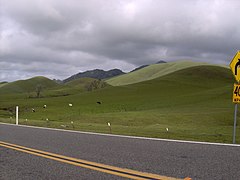 Sutter Buttes, 2006
 -
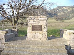 A monument at the base of the mountains indicating that John C. Fremont camped near here
 -
 A close up of the inscription on the memorial.


See also
Notes
- ^ a b c Stienstra, Tom (2004-03-18). "State buys parcel in Sutter Buttes But public access to Peace Valley could take years". San Francisco Chronicle. p. B-1. Retrieved 2009-05-29.
- ^ "South Butte, California". Peakbagger.com. Retrieved 2014-02-21.
- ^ a b State of California, ‘’California Geologic Provinces,’’ Note 36, page 2 Archived 2016-12-22 at the Wayback Machine
- ^ "Yuba City's Sutter Buttes". Retrieved 2014-03-04.
- ^ a b Hausback, Brian P.; Muffler, L.J. Patrick; Clynne, Michael A. (March 2011). "Sutter Buttes—The Lone Volcano in California's Great Valley" (PDF). U.S. Geological Survey.
- ^ Charles A. Wood. 1990
- ^ Soil Survey of Sutter County, California. United States Department of Agriculture, Soil Conservation Service, 1988
- ^ C. Michael Hogan. 2009
- ^ "Sutter Buttes: Maidu`s Spirit Mountain". California Department of Parks and Recreation. Retrieved 10 February 2017.
- ^ "Sutter Buttes: Maidu's Spirit Mountain". Retrieved 27 September 2017.
- ^ Delay, Peter J. (1924). "History of Yuba and Sutter Counties, California". Los Angeles: Historic Record Company. p. 224. OCLC 6061103.
{{cite web}}: Missing or empty|url=(help) - ^ "Sutter Buttes Regional Land Trust - Our History". Retrieved 2015-02-26.
- ^ "Middle Mountain Interpretive Hikes". Retrieved 2015-02-26.
- ^ "Sutter County Historical Society". Retrieved 2015-02-26.
- ^ "Titan 1". California Cold War Museum & Memorial. Retrieved 2008-12-12.
- ^ "California Department of Parks and Recreation page for Sutter Buttes". Retrieved 2017-02-01.
References
- Allan, Stuart (2005). California Road and Recreation Atlas. Benchmark Maps. p. 64. ISBN 0-929591-80-1.
- "Sutter Buttes Regional Land Trust".
- C. Michael Hogan. 2009. Yellow Mariposa Lily: Calochortus luteus, GlobalTwitcher.com, ed. N. Stromberg
- Charles A. Wood; Jürgen Kienle, eds. (1990). Volcanoes of North America. Cambridge University Press. pp. 225–226. ISBN 0-521-43811-X.
- "Sutter Buttes". Geographic Names Information System. United States Geological Survey, United States Department of the Interior.