Little Turcotte River: Difference between revisions
Creation of article "Little Turcotte River" |
(No difference)
|
Revision as of 23:18, 16 October 2017
Template:Geobox The Little Turcotte River is a tributary of the Turcotte River, flowing in the Cochrane District, in Ontario, in Canada.
Forestry is the main economic activity of the sector; recreational tourism activities, second.
The surface of the river is usually frozen from early November to mid-May, but safe circulation on the ice generally occurs from mid-November to the end of April.
Geography
The main slopes waters of the "Little Turcotte River" are:
- North side: Detour River;
- East side: Turgeon River, Garneau River;
- South side: Turcotte River, Burntbush River, Kabika River, Chabbie River;
- West side: Turcotte River, Chabbie River, Burntbush River.
The "Little Turcotte River" originates at the mouth of a small unidentified lake (length: 0.2 kilometres (0.12 mi); altitude: 304 metres (997 ft)) in the eastern part of the Cochrane district, in Ontario.
The mouth of the small head lake is located at:
- 13.9 kilometres (8.6 mi) west of the boundary between Ontario and Quebec;
- 11.5 kilometres (7.1 mi) northwest of the mouth of the “Petite Rivière Turcotte” (confluence with the Turcotte River);
- 25.3 kilometres (15.7 mi) northwest of the mouth of the Turcotte River (confluence with the Turgeon River, in Quebec);
- 65.0 kilometres (40.4 mi) southwest of the mouth of the Turgeon River (in Quebec);
- 60.6 kilometres (37.7 mi) southeast of a southern bay of Kesagami Lake in Ontario.
From the mouth of the small head lake, the "Little Turcotte River" flows on 13.7 kilometres (8.5 mi) according to the following segments:
- 6.7 kilometres (4.2 mi) to the south, curving eastward to the mouth of the Little Turcotte Lake, which the current passes through on {convert|0.8|km};
- 7.0 kilometres (4.3 mi) to South-East by crossing a marsh zone at the beginning of this section.[1]
The "Little Turcotte River" flows into a river bend on the northern shore of the Turcotte River. This confluence is located at:
- 8.8 kilometres (5.5 mi) east of the boundary between Quebec and Ontario;
- 14.0 kilometres (8.7 mi) southwest of the mouth of the Turcotte River (confluence with the Turgeon River);
- 67.5 kilometres (41.9 mi) southwest of the mouth of the Turgeon River (confluence with the Harricana River);
- 72.2 kilometres (44.9 mi) southeast of a southern bay of Kesagami Lake in Ontario.
Toponymy
The term "Turcotte" is a surname of family of French origin.
Notes and references
See also
- District of Cochrane, an administrative district of Ontario
- Turcotte River, a waterscourse
- Turgeon River, a watercourse
- Harricana River, a watercourse
- James Bay, a body of water
- List of rivers of Ontario
Portal maintenance status: (August 2019)
|
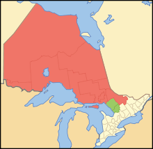
Northern Ontario is a primary geographic and quasi-administrative region of the Canadian province of Ontario, the other primary region being Southern Ontario. Most of the core geographic region is located on part of the Superior Geological Province of the Canadian Shield, a vast rocky plateau located mainly north of Lake Huron (including Georgian Bay), the French River, Lake Nipissing, and the Mattawa River. The statistical region extends south of the Mattawa River to include all of the District of Nipissing. The southern section of this district lies on part of the Grenville Geological Province of the Shield which occupies the transitional area between Northern and Southern Ontario. The extended federal and provincial quasi-administrative regions of Northern Ontario have their own boundaries even further south in the transitional area that vary according to their respective government policies and requirements. Ontario government departments and agencies such as the Growth Plan for Northern Ontario and the Northern Ontario Heritage Fund Corporation define Northern Ontario as all areas north of, and including, the districts of Parry Sound and Nipissing for political purposes, and the federal but not the provincial government also includes the district of Muskoka.
The statistical region has a land area of 806,000 km2 (310,000 mi2) and constitutes 88 percent of the land area of Ontario, but with just 780,000 people, it contains only about six percent of the province's population. The climate is characterized by extremes of temperature, with very cold winters and hot summers. The principal industries are mining, forestry, and hydroelectricity.
For some purposes, Northern Ontario is further subdivided into Northeastern and Northwestern Ontario. When the region is divided in that way, the three westernmost districts (Rainy River, Kenora and Thunder Bay) constitute "Northwestern Ontario," and the other districts constitute "Northeastern Ontario." Northeastern Ontario contains two thirds of Northern Ontario's population. (Full article...)Template:/box-header Template:Little Turcotte River/Surrounding areas
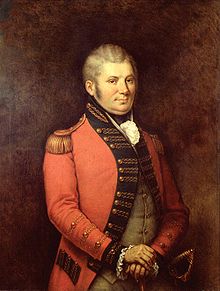
John Graves Simcoe (25 February 1752 – 26 October 1806) was a British Army general and the first lieutenant governor of Upper Canada from 1791 until 1796 in southern Ontario and the watersheds of Georgian Bay and Lake Superior. He founded York, which is now known as Toronto, and was instrumental in introducing institutions such as courts of law, trial by jury, English common law, freehold land tenure, and also in the abolition of slavery in Upper Canada.
His long-term goal was the development of Upper Canada (Ontario) as a model community built on aristocratic and conservative principles, designed to demonstrate the superiority of those principles to the republicanism of the United States. His energetic efforts were only partially successful in establishing a local gentry, a thriving Church of England, and an anti-American coalition with select indigenous nations. He is seen by many Canadians as a founding figure in Canadian history, especially by those in Southern Ontario. He is commemorated in Toronto with Simcoe Day. (Full article...)The page "Little Turcotte River/box-header" does not exist. The page "Little Turcotte River/New did you know/1" does not exist.

Template:/box-header Template:Little Turcotte River/Things you can do
The following Wikimedia Foundation sister projects provide more on this subject:
-
Commons
Free media repository -
Wikibooks
Free textbooks and manuals -
Wikidata
Free knowledge base -
Wikinews
Free-content news -
Wikiquote
Collection of quotations -
Wikisource
Free-content library -
Wikiversity
Free learning tools -
Wikivoyage
Free travel guide -
Wiktionary
Dictionary and thesaurus
- ^ Distances measured from the Atlas of Canada (published on the Internet) of the Department of Natural Resources Canada.


