
Kota Tua Jakarta: Difference between revisions
Rochelimit (talk | contribs) →Gallery: added list of street names |
Rochelimit (talk | contribs) →List of street names: fixed |
||
| Line 74: | Line 74: | ||
==List of street names== |
==List of street names== |
||
{{Expand list|date=August 2015}} |
{{Expand list|date=August 2015}} |
||
Belos is a list of street names in Kota area. The list of road is limited to the road that is now located within the perimeter of the walled city of Batavia. |
Belos is a list of street names in Kota area. The list of road is limited to the road that is now located within the largest extend of the perimeter of the walled city of Batavia, both before and after the attack of [[Sultan Agung]]. |
||
To avoid confusion, the official writing of Roman numeral is converted into an Arabic numeral. |
To avoid confusion, the official writing of Roman numeral is converted into an Arabic numeral. |
||
| Line 84: | Line 84: | ||
! style="width:150px;"|Former name |
! style="width:150px;"|Former name |
||
! style="width:280px;"|Former etymology |
! style="width:280px;"|Former etymology |
||
! style="width: |
! style="width:120px;"|Latest image |
||
! style="width:120px;"|Oldest image |
|||
|- |
|- |
||
|Jalan Bank |
|Jalan Bank |
||
|[[Museum Bank Indonesia]] |
|[[Museum Bank Indonesia]] |
||
|Brugstraat (1650)<ref name="kaart-1667"/>; Hospitaalstraat (1667)<ref name="kaart-1667"/> |
|||
|The street had existed since 1632, but it was named Brugstraat later around 1650. At the same time the Inner Hospital was build to the south of the road, and in 1667 the road name became the Hospitaalstraat.<ref name="kaart-1667"/> |
|||
| |
| |
||
| |
| |
||
|West Jakarta |
|||
|- |
|- |
||
|Jalan Cengkeh |
|Jalan Cengkeh |
||
| Line 96: | Line 98: | ||
|Prinsenstraat<ref name="metamorfose">{{cite book |last1=de Vletter |first1=M.E. |last2=Voskuil |first2=R.P.G.A. |last3=van Diessen |first3=J.R. |date=May 1997 |title=Batavia/Djakarta/Jakarta Beeld van een metamorfose |url= |location=Purmerend |publisher=Asia Maior |pages=110-112 |isbn=9074861091 |access-date=}}</ref> |
|Prinsenstraat<ref name="metamorfose">{{cite book |last1=de Vletter |first1=M.E. |last2=Voskuil |first2=R.P.G.A. |last3=van Diessen |first3=J.R. |date=May 1997 |title=Batavia/Djakarta/Jakarta Beeld van een metamorfose |url= |location=Purmerend |publisher=Asia Maior |pages=110-112 |isbn=9074861091 |access-date=}}</ref> |
||
| |
| |
||
| |
|||
|West Jakarta |
|||
| |
|||
|- |
|- |
||
|Jalan Cengkeh Dalam |
|Jalan Cengkeh Dalam |
||
| Line 102: | Line 105: | ||
| |
| |
||
| |
| |
||
| |
|||
|West Jakarta |
|||
| |
|||
|- |
|- |
||
|Jalan Gedong Panjang |
|Jalan Gedong Panjang |
||
| Line 108: | Line 112: | ||
|Gedong Pandjang |
|Gedong Pandjang |
||
| |
| |
||
| |
|||
|North Jakarta |
|||
| |
|||
|- |
|||
|Jalan Jembatan Batu |
|||
|Stone bridge |
|||
| |
|||
|Originally a southern section of Batavia City wall where Gelderland bastion, Oranje bastion, Hollandia bastion and the Nieuwepoort was constructed around 1632.<ref name="kaart-1667"/> |
|||
| |
|||
| |
|||
|- |
|- |
||
|Jalan Kali Besar Barat |
|Jalan Kali Besar Barat |
||
| Line 114: | Line 126: | ||
|Kali Besar-West<ref name="metamorfose"/> |
|Kali Besar-West<ref name="metamorfose"/> |
||
| |
| |
||
| |
|||
|West Jakarta |
|||
| |
|||
|- |
|- |
||
|Jalan Kali Besar Timur |
|Jalan Kali Besar Timur |
||
| Line 120: | Line 133: | ||
|Kali Besar-Oost<ref name="metamorfose"/> |
|Kali Besar-Oost<ref name="metamorfose"/> |
||
| |
| |
||
| |
|||
|West Jakarta |
|||
| |
|||
|- |
|- |
||
|Jalan Kemukus |
|Jalan Kemukus |
||
| Line 126: | Line 140: | ||
|Binen Kaaimanstraat<ref name="metamorfose"/> |
|Binen Kaaimanstraat<ref name="metamorfose"/> |
||
| |
| |
||
| |
|||
|West Jakarta |
|||
| |
|||
|- |
|- |
||
|Jalan Ketumbar |
|Jalan Ketumbar |
||
| Line 132: | Line 147: | ||
| |
| |
||
| |
| |
||
| |
|||
|West Jakarta |
|||
| |
|||
|- |
|- |
||
|Jalan Kopi |
|Jalan Kopi |
||
| Line 138: | Line 154: | ||
|Utrechtsestraat<ref name="metamorfose"/> |
|Utrechtsestraat<ref name="metamorfose"/> |
||
|Dutch city of [[UTrecht]] |
|Dutch city of [[UTrecht]] |
||
| |
|||
|West Jakarta |
|||
| |
|||
|- |
|- |
||
|Jalan Kunir |
|Jalan Kunir |
||
| Line 144: | Line 161: | ||
|Leeuwinne Gracht |
|Leeuwinne Gracht |
||
| |
| |
||
| |
|||
|West Jakarta |
|||
| |
|||
|- |
|- |
||
|Jalan Lada |
|Jalan Lada |
||
| Line 150: | Line 168: | ||
| |
| |
||
| |
| |
||
| |
|||
|West Jakarta |
|||
| |
|||
|- |
|- |
||
|Jalan Lada Dalam |
|Jalan Lada Dalam |
||
| Line 156: | Line 175: | ||
| |
| |
||
| |
| |
||
| |
|||
|West Jakarta |
|||
| |
|||
|- |
|- |
||
|Jalan Malaka |
|Jalan Malaka |
||
| Line 162: | Line 182: | ||
| |
| |
||
| |
| |
||
| |
|||
|West Jakarta |
|||
| |
|||
|- |
|- |
||
|Jalan Malaka 2 |
|Jalan Malaka 2 |
||
| Line 168: | Line 189: | ||
|Orpa Gang?<ref name="metamorfose"/> |
|Orpa Gang?<ref name="metamorfose"/> |
||
| |
| |
||
| |
|||
|West Jakarta |
|||
| |
|||
|- |
|||
|Jalan Nelayan Timur |
|||
| |
|||
| |
|||
| |
|||
| |
|||
| |
|||
|- |
|- |
||
|Jalan Paus Kel. |
|Jalan Paus Kel. |
||
| Line 174: | Line 203: | ||
| |
| |
||
| |
| |
||
| |
|||
|North Jakarta |
|||
| |
|||
|- |
|- |
||
|Jalan Petak Asem 1 |
|Jalan Petak Asem 1 |
||
| |
| |
||
|Spinhuis Gracht<ref name="metamorfose"/> |
|Spinhuis Gracht or Rhinoceros Gracht (1650)<ref name="metamorfose"/> |
||
|''see Jalan Tiang Bendera 1, 2, 3, and 4'' |
|||
|After the old [[List of colonial buildings and structures in Indonesia|spinning house]] |
|||
| |
|||
|North Jakarta |
|||
| |
|||
|- |
|- |
||
|Jalan |
|Jalan Pintu Besar Utara |
||
| |
| |
||
|Heerenstraat (circa 1627)<ref name="kaart-1667"/> |
|||
|''see Jalan Teh'' |
|||
| |
| |
||
| |
| |
||
|North Jakarta |
|||
|- |
|- |
||
|Jalan |
|Jalan Pintu Besar Selatan |
||
| |
| |
||
|Heerenstraat (circa 1627)<ref name="kaart-1667"/>, Nieuwepoortstraat (circa 1632)<ref name="kaart-1667"/> |
|||
|Theewaterstraat<ref name="metamorfose"/> |
|||
|''see Jalan Teh'' |
|||
| |
|||
| |
| |
||
|West Jakarta |
|||
|- |
|- |
||
|Jalan |
|Jalan Semut Ujung |
||
| |
|||
|Flag pole |
|||
| |
|||
|Maleische Gracht<ref name="metamorfose"/> |
|||
| |
|||
| |
|||
| |
| |
||
|West Jakarta |
|||
|- |
|- |
||
|Jalan |
|Jalan Teh |
||
|Tea |
|||
|Flag pole |
|||
|Heerenstraat (circa 1627)<ref name="kaart-1667">{{cite map |publisher=G.B. Hooyer and J.W. Yzerman |title=Kaart van het Kasteel en de Stad Batavia in het Jaar 1667 |url= |trans_title=Map of the Castle and the City Batavia in year 1667 |language=Dutch |edition=Den Haag |year=1919 |cartography=J.J. Bollee |scale=50 rhijnlandsche roeden |series= |page= |section= |inset= |accessdate=2011-09-08 |isbn= |id= |ref= |archiveurl= |archivedate=}}</ref> |
|||
|Planning of the Heerenstraat or Heerestraat (Gentleman's Street) had existed since 1622; at that time the street has not exist but a port named Heeren Poort which lies on the Vierde dwarsgrachts (a short-lived canal (1619-1632)<ref name="kaart-1667"/> to the south end of the planned street - the point of the port lies exactly at the junction of Jalan Pintu Besar Utara and Jalan Bank).<ref name="kaart-1667"/> At its most extended plan in 1627, Heerenstraat stretched north-to-south from the point at Jalan Nelayan Timur, stretching to Jalan Teh, Jalan Pintu Besar Utara, and Jalan Pintu Besar Selatan. It was the Broadway of Batavia until the [[Siege of Batavia|first offensive of Batavia]] by [[Sultan Agung]], King of the [[Mataram Sultanate]], after which a wall was constructed around 1632<ref name="kaart-1667"/> (along what is now Jalan Jembatan Batu), dividing Heerenstraat into the Heerenstraat (north of the wall, now Jalan Pintu Besar Utara) and Nieuwpoortstraat (now Jalan Pintu Besar Selatan). |
|||
| |
| |
||
| |
| |
||
|West Jakarta |
|||
|- |
|- |
||
|Jalan Tiang Bendera |
|Jalan Tiang Bendera |
||
|Flag pole |
|||
|Spinhuis Gracht<ref name="metamorfose"/> |
|||
|After the old [[List of colonial buildings and structures in Indonesia|spinning house]] |
|||
|West Jakarta |
|||
|- |
|||
|Jalan Tiang Bendera 3 |
|||
|Flag pole |
|Flag pole |
||
|Maleische Gracht <ref name="metamorfose"/> |
|||
|The canal Maleische Gracht, established in 1650 to extend the Amsterdamsche Gracht, existed approximately between Jalan Tiang Bendera and the railway track. |
|||
| |
| |
||
| |
| |
||
|West Jakarta |
|||
|- |
|- |
||
|Jalan Tiang Bendera 4 |
|Jalan Tiang Bendera 1, 2, 3 and 4 |
||
|Flag pole |
|Flag pole |
||
|Spinhuis Gracht or Rhinoceros Gracht (1650)<ref name="metamorfose"/> |
|||
|After the old [[List of colonial buildings and structures in Jakarta|spinning house]] which lies facing the canal. The original street contains a canal called Spinhuis or Rhinoceros Gracht. The street layout on the east of the canal stretched south-to-north from Jalan Tiang Bendera 4, Tiang Bendera 1, Petak Asem 1, and a point at Jalan Paus Kel., while the street on the west of the canal stretched from Jalan Tiang Bendera 3, Tiang Bendera 2, Petak Asem 1, and a point at Jalan Paus Kel. The canal was refilled later in the 20th century.<ref name="kaart-1667"/> |
|||
| |
| |
||
| |
| |
||
|West Jakarta |
|||
|- |
|- |
||
|Jalan Tiang Bendera |
|Jalan Tiang Bendera 5 |
||
|Flag pole |
|Flag pole |
||
|Pendjaringan |
|Pendjaringan |
||
| |
| |
||
| |
|||
|West Jakarta |
|||
| |
|||
|} |
|} |
||
==Gallery== |
==Gallery== |
||
Revision as of 11:47, 16 August 2015

Kota, or known in Indonesian as Kota Tua or Kota Tua Jakarta ("Jakarta Old Town"), is a neighborhood comprising the original downtown area of Jakarta, Indonesia. It is also known as Old Jakarta, and Old Batavia (Dutch: Oud Batavia). It spans 1.3 square kilometres within North Jakarta and West Jakarta (Kelurahan Pinangsia, Taman Sari and Kelurahan Roa Malaka, Tambora). The largely Chinese downtown area of Glodok is a part of Kota Tua.
History
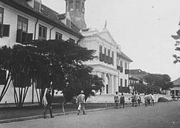
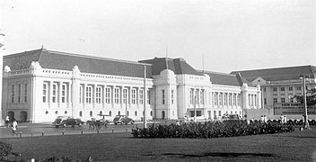
.jpg)
Kota Tua is a remainder of Oud Batavia, the first walled settlement of the Dutch in Jakarta area. The area gained importance during the 17th-19th century when it was established as the de facto capital of the Dutch East Indies. This inner walled city contrasted with the surrounding kampung (villages), orchards, and rice fields. Dubbed "The Jewel of Asia" and "Queen of the East" in the 16th century by European sailors, the area was a center of commerce due to its strategic location within the spice trade industry in the archipelago.
Headquarter of Dutch East India company

In 1526, Fatahillah, sent by Sultanate of Demak, invaded the Hindu Pajajaran's port of Sunda Kelapa, after which he renamed it into Jayakarta. This town was only 15 hectare in size and had a typical Javanese harbor layout. In 1619 the VOC destroyed Jayakarta under the command of Jan Pieterszoon Coen. A year later the VOC built a new town named "Batavia" after the Batavieren, the Dutch ancestors from antiquity. This city was centered around the east bank of the Ciliwung river, around present day Fatahillah Square. Inhabitants of Batavia are called "Batavianen", later known as "Betawi" people. The creole citizens are descendants of mixed various ethnicities that had inhabited Batavia.
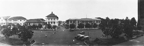
Around 1630 the city expanded towards the west banks of Ciliwung, on the ruins of former Jayakarta. The city was designed in according to Dutch urban planning complete with a fortress (Kasteel Batavia), city wall, public square, churches, canals and tree-lined streets. The city was arranged in several blocks separated by canals. No native Javanese were allowed to live within the city walls, since the authorities were afraid that they might start an insurrection.[1] The planned city of Batavia was completed in 1650. It became the headquarters of the VOC in the East Indies and prospered from the spice trade.
Old Batavia declined in prominence in the late 18th century, likely because the canals with their near-stagnant water, together with the warm and humid climate would often cause outbreaks of tropical diseases like malaria. Much of the old town became neglected and abandoned due to its ailing nature, and slowly its canals were filled up. Countryside villas were preferred by wealthier residents, which caused the city to grow southward. This process led to the foundation of an estate named Weltevreden.
As capital of Dutch East Indies

The city retained its status as the administrative center of the Dutch East Indies when the VOC transferred its possession to the monarch of the Netherlands in 1800.
During the rule of Governor General Daendels in 1808, the city's administration and military were moved south to Weltevreden, with a new planned town center around Koningsplein and Waterlooplein. Due to financial problems however, much of the old town, its wall, and kasteel Batavia were torn down for construction materials to build new government and civic buildings, such as the palace of Daendels (now department of Finance) and the Harmonie society building (demolished). The only remnant of Kasteel Batavia is Amsterdam Gate, which eventually was completely demolished in 1950.
The city continued to expand further south as epidemics in 1835 and 1870 forced more and more people to move out of the old city to the new spacious, green and healthier Weltevreden neighborhood. The old city became deserted and was a mere empty shell of its former glory by this period. Old Batavia kept its commercial importance as the city's main harbor and warehouses district, but it was largely overshadowed by Surabaya as the colony's prime harbor and commercial hub.
After the opening of Tanjung Priok harbor and fueled by the increasing rubber output in the late 19th century, Batavia was able to regain its commercial momentum. There had been attempts to restore the city's old downtown prominence by converting the desolated area to be the main business district of Batavia. As a result the former mansions and shophouses that at the time had been occupied by ethnic Chinese people, were converted and renovated into offices in 1900-1942. Many of these offices can still be seen today around Kali Besar. The development of the business district was hampered by the 1930 Great Depression and the Japanese occupation of Indonesia in 1942.
Post Independent Indonesia

After the recognition of Indonesia's independence in 1950, the business district was moved to Thamrin and Kebayoran Baru in the south, thus allowing the old city to further deteriorate again after having regained some of its lost glory.
In 1972, the Governor of Jakarta, Ali Sadikin, issued a decree that officially designated the Jakarta Kota Tua area as a heritage site. The governor's decision was necessary in order to preserve the city's architectural roots – or at least what was left of it. Despite the Governor's Decree, Kota Tua remained neglected. Even though the majority was pleased just by the issuing of the decree, not enough was being done to protect and conserve the legacy from the Dutch colonial era. Many buildings in Kota Tau remain abandoned, and increasing pollution hastened up the dilapidation rate of the old buildings. Some old buildings in Kali Besar were destroyed for development despite its heritage status, such as Hotel Omni Batavia, which was built over an old warehouse.[2]
Restoration and revitalization
First concrete plan of Kota Tua revitalization was signed in December 2004 by Jakarta Old Town-Kotaku and the government of Jakarta. The commencement of the revitalization plan was started in 2005. Taman Fatahillah Square was revitalized in 2006.[3]
In 2014 the city's governor at that time Joko Widodo continued the restoration plan of Kota Tua. The project, named "Jakarta Old Town Reborn" (JOTR), is a cooperation between state-owned enterprises, the municipal government and the private sector.[4] In March 2014, an event Fiesta Fatahillah was held in Taman Fatahillah Square. The Dutch aided the restoration plan in July 2014. By August 2014, 16 buildings in Kota Tua has been restored, such as the 1929 Modernist Kota Post Office buildings, which has been converted into a contemporary art museum. Despite of this promising developments, most of the city's crumbling colonial architecture remain in ruins up to this day.[5]
Street vendors remain the biggest problem in Kota Tua. Illegal street vendors and hawkers increase dramatically around Kota Tua area, especially during holidays, causing increase in garbage. As of May 2015, 415 street vendors are allowed to sell their items in Kota Tua area.[3]
Notable sites


Nowadays, many remaining historical buildings and architecture are steadily deteriorating, but some of the old buildings have been restored to their former glory. However, there is still much hope in restoring the area, especially with aid from various non-profit organizations, private institutions, and the government[6] all stepping up to the plate to rejuvenate Old Jakarta's legacy. In 2007, several streets surrounding Fatahillah square such as Pintu Besar street and Pos Kota street, were closed to vehicles as a first step towards the rejuvenation. Since 2014 the old town has a brighter future with the ambitious JOTR project to restore Old Batavia's architecture and putting the site on the UNESCO heritage list.[7]
As an important city and commerce hub in Asia since the 16th century, Oud Batavia is home to several important historical sites and buildings:[1]
- Relic from the Old Batavia
- Cafe Batavia
- Fine Art and Ceramic Museum (Former Court of Justice)
- Gereja Sion (17th century church, the oldest surviving church in Jakarta, and probably in Indonesia)
- Jakarta History Museum (18th century City Hall of Oud Batavia)
- Glodok and Pinangsia Area (Jakarta Chinatown)
- Kali Besar (original river of Oud Batavia)
- Kota Intan Drawbridge (the only surviving Dutch drawbridge in Indonesia)
- Luar Batang Mosque
- Maritime Museum and Menara Syahbandar (former warehouses of Oud Batavia)
- Pasar Ikan (Fish Market)
- Port of Sunda Kelapa (the original port of Oud Batavia)
- Jin De Yuan Temple (Vihara Dharma Bhakti, the oldest Buddhist temple in Jakarta)
- Petak Sembilan Chinese Street Market
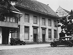
- Toko Merah (18th-century mansion of Governor General Baron Van Imhoff)
- Wayang Museum (20th-century former Museum of Oud Batavia marking the site of the tombstone of Coen)
- Hui Tek Bio Temple
- Early 20th-century revitalization
- Bank Indonesia Museum (former Javasche Bank, the main bank of the Dutch East Indies)
- Chartered Bank of India, Australia and China (Now owned by Bank Mandiri)
- Jakarta Kota Post Office (One of a few samples of Nieuwe Zakelijkheid architecture in Indonesia)
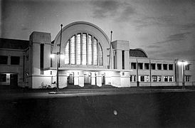
- Jakarta Kota Station (formerly known as BEOS station or Batavia Zuid Station)
- Bank Mandiri Museum (former Netherlands Trading Society (Dutch: Nederlandsche Handelsmaatschappij), one of a few samples of Nieuwe Zakelijkheid architecture in Indonesia)
List of street names
Belos is a list of street names in Kota area. The list of road is limited to the road that is now located within the largest extend of the perimeter of the walled city of Batavia, both before and after the attack of Sultan Agung.
To avoid confusion, the official writing of Roman numeral is converted into an Arabic numeral.
| Official name | Etymology | Former name | Former etymology | Latest image | Oldest image |
|---|---|---|---|---|---|
| Jalan Bank | Museum Bank Indonesia | Brugstraat (1650)[8]; Hospitaalstraat (1667)[8] | The street had existed since 1632, but it was named Brugstraat later around 1650. At the same time the Inner Hospital was build to the south of the road, and in 1667 the road name became the Hospitaalstraat.[8] | ||
| Jalan Cengkeh | Clove | Prinsenstraat[9] | |||
| Jalan Cengkeh Dalam | Clove | ||||
| Jalan Gedong Panjang | Gedong Pandjang | ||||
| Jalan Jembatan Batu | Stone bridge | Originally a southern section of Batavia City wall where Gelderland bastion, Oranje bastion, Hollandia bastion and the Nieuwepoort was constructed around 1632.[8] | |||
| Jalan Kali Besar Barat | West of Great River | Kali Besar-West[9] | |||
| Jalan Kali Besar Timur | East of Great River | Kali Besar-Oost[9] | |||
| Jalan Kemukus | Java pepper | Binen Kaaimanstraat[9] | |||
| Jalan Ketumbar | Coriander | ||||
| Jalan Kopi | Coffee | Utrechtsestraat[9] | Dutch city of UTrecht | ||
| Jalan Kunir | Turmeric | Leeuwinne Gracht | |||
| Jalan Lada | Pepper | ||||
| Jalan Lada Dalam | Inner Pepper | ||||
| Jalan Malaka | |||||
| Jalan Malaka 2 | Orpa Gang?[9] | ||||
| Jalan Nelayan Timur | |||||
| Jalan Paus Kel. | |||||
| Jalan Petak Asem 1 | Spinhuis Gracht or Rhinoceros Gracht (1650)[9] | see Jalan Tiang Bendera 1, 2, 3, and 4 | |||
| Jalan Pintu Besar Utara | Heerenstraat (circa 1627)[8] | see Jalan Teh | |||
| Jalan Pintu Besar Selatan | Heerenstraat (circa 1627)[8], Nieuwepoortstraat (circa 1632)[8] | see Jalan Teh | |||
| Jalan Semut Ujung | |||||
| Jalan Teh | Tea | Heerenstraat (circa 1627)[8] | Planning of the Heerenstraat or Heerestraat (Gentleman's Street) had existed since 1622; at that time the street has not exist but a port named Heeren Poort which lies on the Vierde dwarsgrachts (a short-lived canal (1619-1632)[8] to the south end of the planned street - the point of the port lies exactly at the junction of Jalan Pintu Besar Utara and Jalan Bank).[8] At its most extended plan in 1627, Heerenstraat stretched north-to-south from the point at Jalan Nelayan Timur, stretching to Jalan Teh, Jalan Pintu Besar Utara, and Jalan Pintu Besar Selatan. It was the Broadway of Batavia until the first offensive of Batavia by Sultan Agung, King of the Mataram Sultanate, after which a wall was constructed around 1632[8] (along what is now Jalan Jembatan Batu), dividing Heerenstraat into the Heerenstraat (north of the wall, now Jalan Pintu Besar Utara) and Nieuwpoortstraat (now Jalan Pintu Besar Selatan). | ||
| Jalan Tiang Bendera | Flag pole | Maleische Gracht [9] | The canal Maleische Gracht, established in 1650 to extend the Amsterdamsche Gracht, existed approximately between Jalan Tiang Bendera and the railway track. | ||
| Jalan Tiang Bendera 1, 2, 3 and 4 | Flag pole | Spinhuis Gracht or Rhinoceros Gracht (1650)[9] | After the old spinning house which lies facing the canal. The original street contains a canal called Spinhuis or Rhinoceros Gracht. The street layout on the east of the canal stretched south-to-north from Jalan Tiang Bendera 4, Tiang Bendera 1, Petak Asem 1, and a point at Jalan Paus Kel., while the street on the west of the canal stretched from Jalan Tiang Bendera 3, Tiang Bendera 2, Petak Asem 1, and a point at Jalan Paus Kel. The canal was refilled later in the 20th century.[8] | ||
| Jalan Tiang Bendera 5 | Flag pole | Pendjaringan |
Gallery
-
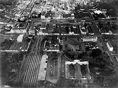 View of the Stadhuisplein or Taman Fatahillah from the air in 1920s.
 -
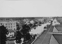
 View of Kali Besar from the air in 1930s.
 -
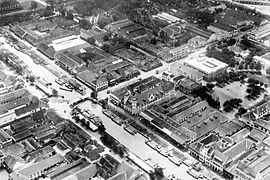
 Aerial view of Stationsplein in 1930s.
 -
 View Kali Besar Canal (Groote Gracht), 1931.
 -
 Former Batavia city hall, 1932.
 -
 Stadhuisplein, now Taman Fatahillah in 1930s.
 -
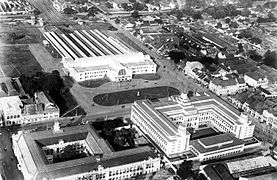
 Stationsplein in Batavia, overlooking the NHM building (Museum Bank Mandiri).
 -
 BEOS Station in 1930s.
 -
 Red Shop/Toko Merah in 1932.
 -
 The Chartered Bank of India, Australia and China in 1921.
 -
 former headquarters of the Javasche Bank, now Bank Indonesia's museum in 1938.
 -
 One of the few surviving VOC era residences in Roa Malacca, 1921.
 -
 Chinese shops and houses of Old Batavia in 1932, today's Jalan Kunir.


References
- ^ a b Kota Tua Jakarta booklet, Dinas Kebudayaan dan Permuseuman Pemerintah Provinsi DKI Jakarta
- ^ 75% of Old Town Crumbling -- No Incentive from the Government, Kompas, March 6, 2006
- ^ a b Litbang "Kompas"/GRH (18 May 2015). "Menunggu Bangkitnya Sang Ratu dari Timur". Kompas (in Indonesian). Jakarta.
{{cite news}}:|access-date=requires|url=(help) - ^ New Life for an Old Town, forbesindonesia, May 4, 2014
- ^ The rebirth of Jakarta’s Old Town, thejakartapost, July 23, 2014
- ^ Old Town Revitalization Becomes a Priority for Provincial Gov't of DKI Jakarta, Kompas, June 10, 2006
- ^ Kota Tua strong contender UNESCO heritage nominees list, thejakartapost, February 4, 2015
- ^ a b c d e f g h i j k l Kaart van het Kasteel en de Stad Batavia in het Jaar 1667 (Map) (Den Haag ed.). 50 rhijnlandsche roeden (in Dutch). Cartography by J.J. Bollee. G.B. Hooyer and J.W. Yzerman. 1919.
{{cite map}}:|access-date=requires|url=(help); Unknown parameter|trans_title=ignored (|trans-title=suggested) (help) - ^ a b c d e f g h i de Vletter, M.E.; Voskuil, R.P.G.A.; van Diessen, J.R. (May 1997). Batavia/Djakarta/Jakarta Beeld van een metamorfose. Purmerend: Asia Maior. pp. 110–112. ISBN 9074861091.