Kozhikode International Airport: Difference between revisions
Expanded refs |
→Accidents and incidents: Added incident |
||
| Line 103: | Line 103: | ||
==Accidents and incidents== |
==Accidents and incidents== |
||
*On 17 January 1969, [[Douglas C-47 Skytrain|Douglas C-47A]] VT-DTH of Hindu Publications crashed on take-off. The aircraft was operating a cargo flight. Both crew were killed.That time the airport had been initialized as an air strip at "Chelari", a few Kilometers away from the current location.<ref name=ASN170169>{{cite web|url=http://aviation-safety.net/database/record.php?id=19690117-0 |title=VT-DTH Accident Description |publisher=Aviation Safety Network |accessdate=23 January 2011}}</ref> |
*On 17 January 1969, [[Douglas C-47 Skytrain|Douglas C-47A]] VT-DTH of Hindu Publications crashed on take-off. The aircraft was operating a cargo flight. Both crew were killed.That time the airport had been initialized as an air strip at "Chelari", a few Kilometers away from the current location.<ref name=ASN170169>{{cite web|url=http://aviation-safety.net/database/record.php?id=19690117-0 |title=VT-DTH Accident Description |publisher=Aviation Safety Network |accessdate=23 January 2011}}</ref> |
||
*On 7 November 2008 an Air India Airbus 310 flight AI 962 flying from Jeddah, Saudi Arabia, scraped its right wing tip on the runway on landing. Certain parts of the plane's wing broke leaving a mark on the runway.<ref name="Hindu 2012">[[http://www.hindu.com/2008/11/08/stories/2008110855721300.htm Narrow escape for AI passengers ]] The Hindu 8 November 2008</ref> |
|||
*On 9 July 2012 an an [[Air India Express]] [[Boeing 737-800]] skidded on landing, during heavy rain. The aircraft's landing gear impacted with runway beacons breaking them.<ref name="IT 2012">[[http://indiatoday.intoday.in/story/politics-and-commercial-considerations-override-safety-concerns-for-dgca/1/235469.html On a Wing and a Prayer]] India Today 30 November 2012</ref> There were no casualties on board.<ref name="IT 2012"/> |
*On 9 July 2012 an an [[Air India Express]] [[Boeing 737-800]] skidded on landing, during heavy rain. The aircraft's landing gear impacted with runway beacons breaking them.<ref name="IT 2012">[[http://indiatoday.intoday.in/story/politics-and-commercial-considerations-override-safety-concerns-for-dgca/1/235469.html On a Wing and a Prayer]] India Today 30 November 2012</ref> There were no casualties on board.<ref name="IT 2012"/> |
||
Revision as of 09:33, 17 April 2013
Calicut International Airport | |||||||||||
|---|---|---|---|---|---|---|---|---|---|---|---|
 Calicut International Airport | |||||||||||
| Summary | |||||||||||
| Airport type | Public | ||||||||||
| Operator | Airports Authority of India | ||||||||||
| Serves | Kozhikode, Malappuram, Kannur, Kasaragod, Wayanad, Palakkad | ||||||||||
| Location | Karipur, Malappuram, Kerala, India | ||||||||||
| Hub for | |||||||||||
| Elevation AMSL | 342 ft / 104 m | ||||||||||
| Coordinates | 11°08′13″N 075°57′19″E / 11.13694°N 75.95528°E | ||||||||||
| Website | aai.aero/allAirports/... | ||||||||||
| Runways | |||||||||||
| |||||||||||
| Statistics (Apr '10 - Mar '11) | |||||||||||
| |||||||||||
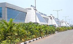
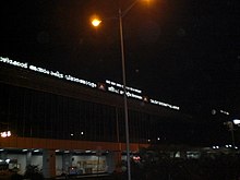
Calicut International Airport (IATA: CCJ, ICAO: VOCL), also known as Karipur Airport, is an International Airport serving the cities of Kozhikode (Calicut) and Malappuram in Kerala, India. The airport is located in Karipur, Malappuram district about 28 km (17 mi) from the Kozhikode Railway Station and 25 km (16 mi) from the city of Malappuram, with the closest railway station being at Feroke. Air India Express has a base at the airport. It is the seventh busiest airport in the country in terms of international passenger traffic and the ninth busiest airport in India in terms of overall passenger traffic.[4]
The airport was given the international airport status on 2 February 2006, thereby paving the way for the improvement of infrastructure for handling international flights.[5][6] It is the third busiest airport in Kerala.
History
The airport was sanctioned after a long period of struggle which began in 1977 under the leadership of freedom fighter K. P. Kesava Menon. Funds were collected from Gulf Malayalis for its development in the 1990s when the Union Government said it did not have funds. To raise the funds needed for airport development, the Malabar International Airport Development Society was formed. Later major developments of facilities, such as extension of runway from 6,000 ft (1,800 m) to 9,000 ft (2,700 m) to facilitate operation of wide-body aircraft were carried out with loans from the Housing and Urban Development Corporation (HUDCO).
The airport was inaugurated in April 1988.[7]
Recent renovation, upgrades and expansion
This section needs additional citations for verification. (December 2010) |
Due to the recent billion-rupee upgrade of existing facilities, the infrastructure at Calicut International Airport has received foreign airlines. [citation needed]
An automated inline baggage system, the first of its kind in India that will do away with the separate X-raying of baggage, is being installed. Several airlines have sought night parking facility at the airport, which has presently 10 parking bays. Permitting night parking at the airport will greatly improve air connectivity. Airports Authority of India (AAI) will provide three automated boarding/deboarding bridges aerobridges (plus options for two more) at the airport which will help passengers directly enter the terminal while alighting from an aircraft. A 15,000 m2 (160,000 sq ft) international terminal has been opened to passengers, similar to the spacious modern international departure terminal that became operational on 14 May 2007. Three user-friendly conveyor belts are installed at the arrival terminal and 800 stainless steel chairs for passengers in the security-hold area. Escalators and elevators are also installed inside and outside the terminal building. Facilities for the passengers and visitors like fast-food counters, luggage room, jewellery shop, handicraft stall, traffic direction poles, restaurant, and cyber café are also opened at the airport.
The plush and practical interiors and convenient facilities, including leather sleeperettes for transit passengers, has definitely brought the airport to international standards; a great improvement from the stuffy and cramped area it once was.[8]
Domestic carrier Jet Airways has being granted permission to operate some international routes, Doha and Muscat. The airline has started its operation from Calicut International Airport from 23 January 2008. It is expected that Deccan will soon follow the path of Jet Airways in August 2008 when it will have completed five years of flying experience to be eligible for international routes.


Lead-in lighting system
The approach to Calicut airport runway is surrounded with hills and valleys. The approach funnel area of the runway 28 is a 30 m (98 ft) to 70 m (230 ft) deep undulated valley up to a distance of 6,000 m (20,000 ft), immediately following the tabletop runway of 2,860 m (9,380 ft) long. This terrain needs a special type of Approach guidance lighting system to enhance safety for aircraft operations both during night and poor visibility conditions. Airports Authority of India have provided runway lead-in lighting system for the first time in India at Calicut airport as per the recommendations of the Directorate General of Civil Aviation, at a cost of Indian Rupees 17,000,000.
The lead-in lighting system is a positive visual guidance to the pilot along a specific approach path for reasons such as avoiding hazardous terrain, etc. It facilitates the pilot to follow the desired approach path. The system is designed in such way that one group of lights is sighted from the preceding group of lights, finally leading the aircraft to the proximity of threshold of the runway. As per standards the runway lead-in lighting system, consist of groups of lights positioned on the desired approach path at an interval of not more than 1,600 m (5,200 ft) on the extended approach path of the runway. The desired approach path could be curved or straight line.
The lead-in-lighting system at Calicut airport provides desired approach path in the extended centreline of the runway and the group of light units are installed on the top of the 30 m (98 ft) high lattice towers at four locations: 1,820 m (5,970 ft), 3,123 m (10,246 ft), 4,271 m (14,012 ft) and 6,193 m (20,318 ft) from the threshold of runway 28. Each group of light consists of three sequential flashing lights in linear configuration. The lead-in-light units are powered through solar power system at each tower locations with battery banks and inverters. The lead-in-light system is planned with radio control units for remote operation. The System operates in three pre-selected intensity level at a flashing rate of 120 flashes per minute to meet the various ambient conditions.
The system has been put into service for night operations since October 2003. The radio frequency control for remote operations of the system from ATC air traffic control tower is also planned.
Supplementing the above lead-in lighting system, solar-powered aviation obstruction lights are also provided at eight critical hilltops around the Calicut Airfield.
Airlines and destinations
Almost all international flights operating from the airport are to Middle East destinations targeting the large NRI population of north Kerala working in the Gulf.
| Airlines | Destinations |
|---|---|
| Air Arabia | Sharjah |
| Air India | Coimbatore, Delhi, Dubai, Jeddah, Mumbai, Riyadh, Sharjah |
| Air India Express | Abu Dhabi, Al Ain, Bahrain, Doha, Dammam, Dubai, Kochi, Kuwait, Muscat, Mumbai, Sharjah, Trivandrum |
| Emirates | Dubai |
| Etihad Airways | Abu Dhabi |
| JetKonnect | Mumbai |
| Oman Air | Muscat |
| Qatar Airways | Doha |
| RAK Airways | Ras al-Khaimah |
| Saudia | Riyadh,Jeddah,Dammam |
| SriLankan Airlines | Colombo |
| SpiceJet | Chennai, Hyderabad |
Cargo
| Airlines | Destinations |
|---|---|
| Emirates SkyCargo | Dubai [9] |
| Expoair Cargo | Colombo |
| Qatar Airways Cargo | Doha[10] |
Accidents and incidents
- On 17 January 1969, Douglas C-47A VT-DTH of Hindu Publications crashed on take-off. The aircraft was operating a cargo flight. Both crew were killed.That time the airport had been initialized as an air strip at "Chelari", a few Kilometers away from the current location.[11]
- On 7 November 2008 an Air India Airbus 310 flight AI 962 flying from Jeddah, Saudi Arabia, scraped its right wing tip on the runway on landing. Certain parts of the plane's wing broke leaving a mark on the runway.[12]
- On 9 July 2012 an an Air India Express Boeing 737-800 skidded on landing, during heavy rain. The aircraft's landing gear impacted with runway beacons breaking them.[13] There were no casualties on board.[13]
References
- ^ TRAFFIC STATISTICS - INTERNATIONAL PASSENGERS Airports Authority of India
- ^ TRAFFIC STATISTICS - INTERNATIONAL AIRCRAFT MOVEMENTS Airports Authority of India
- ^ TRAFFIC STATISTICS - INTERNATIONAL FREIGHT Airports Authority of India
- ^ AAI traffic figures 2009-2011
- ^ Calicut Airport
- ^ Calicut airport given international status
- ^ "Silver jubilee does not bring cheer to Karipur airport users". The Times Of India. 2 April 2012.
- ^ Arab News 11-AUG-2007, Ameen Ali Rafeek
- ^ Emirates SkyCargo Schedule
- ^ QR Cargo to CCJ
- ^ "VT-DTH Accident Description". Aviation Safety Network. Retrieved 23 January 2011.
- ^ [Narrow escape for AI passengers ] The Hindu 8 November 2008
- ^ a b [On a Wing and a Prayer] India Today 30 November 2012
