
Brunswick, Maine: Difference between revisions
Hantsheroes (talk | contribs) No edit summary |
Hantsheroes (talk | contribs) |
||
| Line 50: | Line 50: | ||
==History== |
==History== |
||
[[File:Brunswick Maine map 1795.jpg|thumb|left|Map of Brunswick, May 29, 1795]] |
[[File:Brunswick Maine map 1795.jpg|thumb|left|Map of Brunswick, May 29, 1795]] |
||
Settled in 1628 by Thomas Purchase and other [[fishermen]], the area was called by its [[Indigenous peoples of the Americas|Indian]] name, Pejepscot, meaning "the long, rocky [[rapids]] part [of the river]". In 1639, Purchase placed his settlement under protection of the [[Massachusetts Bay Colony]]. During [[King Philip's War]] in 1676, Pejepscot was burned and abandoned, although a [[garrison]] called [[Edmund Andros|Fort Andros]] was built on the ruins during [[King William's War]]. |
Settled in 1628 by Thomas Purchase and other [[fishermen]], the area was called by its [[Indigenous peoples of the Americas|Indian]] name, Pejepscot, meaning "the long, rocky [[rapids]] part [of the river]". In 1639, Purchase placed his settlement under protection of the [[Massachusetts Bay Colony]]. During [[King Philip's War]] in 1676, Pejepscot was burned and abandoned, although a [[garrison]] called [[Edmund Andros|Fort Andros]] was built on the ruins during [[King William's War]]. During the war, in Major [[Benjamin Church (military officer)| Benjamin Church]]'s second expedition a year later on 11 September 1690 he arrived with 300 men as Casco Bay. He went up [[Androscoggin River]] to the English fort Pejepscot Fort (present day [[Brunswick, Maine]]).<ref>Drake, The Border Wars of New England. p. 66</ref> From there he went 40 miles up river an attacked a native village. 3-4 native men shot in retreat; Church discovered 5 english captives in the wigwams; six or seven prisoners butchered as an examplee<ref>Drake, p. (67); </ref>; nine prisoners taken. A few days later, in retaliation, the natives attacked Church at [[Cape Elizabeth, Maine|Cape Elizabeth]] on Purpooduc Point, killing 7 of his men and wounding 24 others.<ref>Drake, p. .(p.69).</ref> On September 26, Church returned to Portsmouth, Maine. |
||
The [[Treaty of Portsmouth (1713)|1713 Treaty of Portsmouth]] brought peace to the region between the [[Abenaki people|Abenaki]] Indians and [[English people|English]] colonists. <ref name=Coolidge>{{Cite book | last = Coolidge | first = Austin J.| coauthors = John B. Mansfield | title = A History and Description of New England| year = 1859| location = Boston, Massachusetts| pages = 75–77| url = http://books.google.com/books?id=OcoMAAAAYAAJ&lpg=PA9&ots=cUndZkVSIF&dq=coolidge%20mansfield%20history%20description%20new%20england%201859&pg=PA75#v=onepage&q&f=false}}</ref> |
|||
In 1714, a [[consortium]] from [[Boston, Massachusetts|Boston]] and [[Portsmouth, New Hampshire|Portsmouth]] bought the land, thereafter called the [[Pejepscot Purchase]]. The [[Massachusetts General Court]] constituted the township in 1717, naming it Brunswick in honor of the [[House of Brunswick]] and its scion, [[George I of Great Britain|King George I]]. A stone fort called [[Fort George (Maine)|Fort George]] was built in 1715 near the falls. But during [[Dummer's War]] on July 13, 1722, Abenaki warriors from [[Norridgewock]] burned the village. Consequently, Governor [[Samuel Shute]] declared war on the Abenakis. In 1724, 208 English troops left [[Richmond, Maine|Fort Richmond]] and sacked Norridgewock during [[Dummer's War]]. Brunswick was rebuilt again in 1727, and in 1739 incorporated a town. It became a prosperous [[seaport]], where [[Bowdoin College]] was chartered in 1794. <ref name=Coolidge>{{Cite book | last = Coolidge | first = Austin J.| coauthors = John B. Mansfield | title = A History and Description of New England| year = 1859| location = Boston, Massachusetts| pages = 75–77| url = http://books.google.com/books?id=OcoMAAAAYAAJ&lpg=PA9&ots=cUndZkVSIF&dq=coolidge%20mansfield%20history%20description%20new%20england%201859&pg=PA75#v=onepage&q&f=false}}</ref> |
In 1714, a [[consortium]] from [[Boston, Massachusetts|Boston]] and [[Portsmouth, New Hampshire|Portsmouth]] bought the land, thereafter called the [[Pejepscot Purchase]]. The [[Massachusetts General Court]] constituted the township in 1717, naming it Brunswick in honor of the [[House of Brunswick]] and its scion, [[George I of Great Britain|King George I]]. A stone fort called [[Fort George (Maine)|Fort George]] was built in 1715 near the falls. But during [[Dummer's War]] on July 13, 1722, Abenaki warriors from [[Norridgewock]] burned the village. Consequently, Governor [[Samuel Shute]] declared war on the Abenakis. In 1724, 208 English troops left [[Richmond, Maine|Fort Richmond]] and sacked Norridgewock during [[Dummer's War]]. Brunswick was rebuilt again in 1727, and in 1739 incorporated a town. It became a prosperous [[seaport]], where [[Bowdoin College]] was chartered in 1794. <ref name=Coolidge>{{Cite book | last = Coolidge | first = Austin J.| coauthors = John B. Mansfield | title = A History and Description of New England| year = 1859| location = Boston, Massachusetts| pages = 75–77| url = http://books.google.com/books?id=OcoMAAAAYAAJ&lpg=PA9&ots=cUndZkVSIF&dq=coolidge%20mansfield%20history%20description%20new%20england%201859&pg=PA75#v=onepage&q&f=false}}</ref> |
||
Revision as of 09:29, 27 February 2011
Town of Brunswick | |
|---|---|
 Federal Street in 1906 | |
 Seal | |
| Country | United States |
| State | Maine |
| County | Cumberland |
| Settled | 1628 |
| Incorporated (town) | 1739 |
| Area | |
| • Total | 54.2 sq mi (140.4 km2) |
| • Land | 46.8 sq mi (121.2 km2) |
| Population (2000) | |
| • Total | 21,172 |
| • Density | 452.6/sq mi (174.7/km2) |
| Time zone | UTC-5 (Eastern) |
| • Summer (DST) | UTC-4 (Eastern) |
| ZIP code | 04011 |
| Website | www.brunswickme.org |
Brunswick (formerly Pejepscot, Scituate [1]) is a town in Cumberland County, Maine, United States. The population was 21,172 at the 2000 census. It is part of the Portland-South Portland-Biddeford metropolitan area. Brunswick is home to Bowdoin College, the Bowdoin College Museum of Art, the Peary-MacMillan Arctic Museum and the Naval Air Station Brunswick.
History

Settled in 1628 by Thomas Purchase and other fishermen, the area was called by its Indian name, Pejepscot, meaning "the long, rocky rapids part [of the river]". In 1639, Purchase placed his settlement under protection of the Massachusetts Bay Colony. During King Philip's War in 1676, Pejepscot was burned and abandoned, although a garrison called Fort Andros was built on the ruins during King William's War. During the war, in Major Benjamin Church's second expedition a year later on 11 September 1690 he arrived with 300 men as Casco Bay. He went up Androscoggin River to the English fort Pejepscot Fort (present day Brunswick, Maine).[2] From there he went 40 miles up river an attacked a native village. 3-4 native men shot in retreat; Church discovered 5 english captives in the wigwams; six or seven prisoners butchered as an examplee[3]; nine prisoners taken. A few days later, in retaliation, the natives attacked Church at Cape Elizabeth on Purpooduc Point, killing 7 of his men and wounding 24 others.[4] On September 26, Church returned to Portsmouth, Maine.
The 1713 Treaty of Portsmouth brought peace to the region between the Abenaki Indians and English colonists. [5]
In 1714, a consortium from Boston and Portsmouth bought the land, thereafter called the Pejepscot Purchase. The Massachusetts General Court constituted the township in 1717, naming it Brunswick in honor of the House of Brunswick and its scion, King George I. A stone fort called Fort George was built in 1715 near the falls. But during Dummer's War on July 13, 1722, Abenaki warriors from Norridgewock burned the village. Consequently, Governor Samuel Shute declared war on the Abenakis. In 1724, 208 English troops left Fort Richmond and sacked Norridgewock during Dummer's War. Brunswick was rebuilt again in 1727, and in 1739 incorporated a town. It became a prosperous seaport, where Bowdoin College was chartered in 1794. [5]
The Androscoggin River falls in three successive stages over a distance of 41 feet, providing water power for industry. Brunswick became a major producer of lumber, with as many as 25 sawmills. Some of the lumber went into shipbuilding. Other firms produced paper, soap, flour, marble and granite work, carriages and harness, plows, furniture, shoes and confections. The town was site of the first cotton mill in Maine, the Brunswick Cotton Manufactory Company, built in 1809 to make yarn. Purchased in 1812, the mill was enlarged by the Maine Cotton & Woolen Factory Company. [6] In 1857, the Cabot Manufacturing Company was established to make cotton textiles. It bought the failed Worumbo Mill and expanded the brick factory along the falls. Needing even more room, the company in 1890 persuaded the town to move Maine Street. [7]
Brunswick today has a number of historic districts recognized on the National Register of Historic Places, including the Pennellville Historic District, to preserve shipbuilders' and sea captains' mansions built in the Federal, Greek Revival and Italianate architectural styles. Principal employers for Brunswick include Naval Air Station Brunswick, L.L. Bean, Bath Iron Works, as well as companies that produce fiberglass construction material and electrical switches. A number of health services providers serving Maine's mid-coast area are located in Brunswick. [8]
The book Uncle Tom's Cabin was written by Harriet Beecher Stowe while she was living in Brunswick because her husband was a professor at Bowdoin. She got a key vision for the book in the First Parish Church. [9] A scene in the 1993 movie The Man Without a Face was filmed in the town. [10]
-
 Brunswick Falls c. 1912
 -
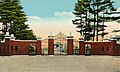 Class of 1903 Gates at Bowdoin c. 1920
 -
 Massachusetts Hall at Bowdoin in 1907
 -
 Merrymeeting Park Casino c. 1905


Geography
According to the United States Census Bureau, the town has a total area of 54.2 square miles (140.4 km²), of which, 46.8 square miles (121.2 km²) of it is land and 7.4 square miles (19.3 km²) of it (13.72%) is water. Brunswick is located at the head of Casco Bay, as well as the head of tide and head of navigation on the Androscoggin River.
The town is served by Interstate 295, U.S. Route 1 and 201, and Maine State Route 24, Maine State Route 123 and Maine State Route 196.
Neighboring cities and towns
Places adjacent to Brunswick, Maine | |
|---|---|
Demographics

As of the censusTemplate:GR of 2000, there were 21,172 people, 8,150 households, and 5,150 families residing in the town. The population density was 452.6 people per square mile (174.7/km²). There were 8,720 housing units at an average density of 186.4/sq mi (72.0/km²). The racial makeup of the town was 94.35% White, 1.71% Black or African American, 0.23% Native American, 1.67% Asian, 0.06% Pacific Islander, 0.63% from other races, and 1.36% from two or more races. Hispanic or Latino of any race were 1.62% of the population.
There were 8,150 households out of which 31.1% had children under the age of 18 living with them, 51.6% were married couples living together, 8.7% had a female householder with no husband present, and 36.8% were non-families. 30.8% of all households were made up of individuals and 13.5% had someone living alone who was 65 years of age or older. The average household size was 2.34 and the average family size was 2.95.

In the town the population was spread out with 23.0% under the age of 18, 14.1% from 18 to 24, 26.9% from 25 to 44, 20.5% from 45 to 64, and 15.5% who were 65 years of age or older. The median age was 36 years. For every 100 females there were 93.1 males. For every 100 females age 18 and over, there were 89.0 males.
The median income for a household in the town was $40,402, and the median income for a family was $49,088. Males had a median income of $32,141 versus $24,927 for females. The per capita income for the town was $20,322. About 5.0% of families and 8.0% of the population were below the poverty line, including 8.6% of those under age 18 and 8.1% of those age 65 or over.
With the closure of the Brunswick Naval Air Station, population for the town is expected to decline for the 2010 Census.
Education
- Brunswick High School
- Children's School of Arts & Science
- Saint John's Catholic School
- Bowdoin College
Sites of interest

- Brunswick Maine Street Station
- Androscoggin Pedestrian Swinging Bridge
- Bowdoin College Museum of Art
- Peary-MacMillan Arctic Museum
- Pejepscot Historical Society (official website)
- Pejepscot Museum
- Joshua L. Chamberlain Museum
- Skolfield-Whittier House
- Pennellville Historic District
Notable people

- Gorham Dummer Abbot, clergyman and teacher [citation needed]
- John Stevens Cabot Abbott, clergyman and author
- Dale Arnold, sportscaster and radio personality [citation needed]
- Corey Beaulieu, musician
- Josh Casaubon, actor
- Fanny Chamberlain, wife of Joshua Chamberlain
- Joshua Chamberlain, Civil War era general and 32nd governor of Maine
- Robert P. T. Coffin, poet
- Robert P. Dunlap, congressman, 11th governor of Maine
- Charles Carroll Everett, theologian
- John Gould, reporter, columnist
- Frederic Aldin Hall, professor, school chancellor
- Joshua Herrick, congressman
- Graeme K., musician
- Angus King, 72nd governor of Maine
- Stump Merrill, baseball player
- Will Montgomery, football player
- Benjamin Orr, congressman
- Alpheus Spring Packard, professor
- George Palmer Putnam, publisher
- Mark Rogers, pitcher for the Milwaukee Brewers
- Harriet Beecher Stowe, abolitionist, author
- Jeff Thisted, game show host [citation needed]
References
- ^ Scituate (now Brunswick) map, 1738; Maine Historical Society
- ^ Drake, The Border Wars of New England. p. 66
- ^ Drake, p. (67);
- ^ Drake, p. .(p.69).
- ^ a b Coolidge, Austin J. (1859). A History and Description of New England. Boston, Massachusetts. pp. 75–77.
{{cite book}}: Unknown parameter|coauthors=ignored (|author=suggested) (help)CS1 maint: location missing publisher (link) - ^ Varney, George J. (1886), Gazetteer of the state of Maine. Brunswick, Boston: Russell
- ^ Historical Sketch of Brunswick, Maine (1889)
- ^ Southern Midcoast Maine Chamber of Commerce
- ^ House of Harriet Beecher Stowe, National Park Service
- ^ Southern Midcoast Maine Chamber of Commerce
Further reading
- History of the Town Commons, Brunswick, Maine
- History of Brunswick, Topsham, and Harpswell, Maine Including Ancient Pejebscot. By George Augustus Wheeler and Henry Warren Wheeler. Published 1878. Full image at books.google.
External links
- Town of Brunswick, Maine
- Curtis Memorial Library
- New Meadows Watershed Partnership
- Template:Wikitravel
Municipalities and communities of Cumberland County, Maine, United States | ||
|---|---|---|
| Cities |  | |
| Towns | ||
| CDPs | ||
| Other villages | ||