
Barrmill, North Ayrshire: Difference between revisions
Rosser1954 (talk | contribs) |
Rosser1954 (talk | contribs) |
||
| Line 44: | Line 44: | ||
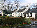
[[Image:Bellcraig and Craufurd Terrace.JPG|180px|thumb|left|Bellcraig and Crawford Terrace.]] |
[[Image:Bellcraig and Craufurd Terrace.JPG|180px|thumb|left|Bellcraig and Crawford Terrace.]] |
||
[[Image:Bellcraig old quarry.JPG|thumb|180px|The old flooded limestone quarry at Bellcraig.]] |
[[Image:Bellcraig old quarry.JPG|thumb|180px|The old flooded limestone quarry at Bellcraig.]] |
||
Bellcraig House stood near the old entrance to Bogston House and was destroyed by quarrying for whinstone. In 1844 John ritchie of Bellcraigs died.<ref>The High Church. A Illustrated Guide. 1983, p. 48</ref> |
|||
Bellcraig and Crawford Terrace form a small hamlet close to Barrmill. The Braefoot Building stood on the other, north side of the road, owned by Merry & Cunningham the ironmasters. The building was demolished in 1956 and the residents moved to new housing in Beith. The Mack family were onetime residents.<ref>Reid, Donald L. ''Old Beith''. Ochiltree:Stenlake Publishing. ISBN 1-84033-1267. Page 43</ref> |
Bellcraig and Crawford Terrace form a small hamlet close to Barrmill. The Braefoot Building stood on the other, north side of the road, owned by Merry & Cunningham the ironmasters. The building was demolished in 1956 and the residents moved to new housing in Beith. The Mack family were onetime residents.<ref>Reid, Donald L. ''Old Beith''. Ochiltree:Stenlake Publishing. ISBN 1-84033-1267. Page 43</ref> |
||
These houses, some of which housed quarry workers, lie close to a 20th century limestone quarry nearby, now abandoned and filled with water. The area had many small limestone and ironstone quarries. Dockra and [[Gateside (Garnock)|Broadstone]] quarries are quite nearby. Around 30 people were employed here in the 1930s. |
These houses, some of which housed quarry workers, lie close to a 20th century limestone quarry nearby, now abandoned and filled with water. The area had many small limestone and ironstone quarries. Dockra and [[Gateside (Garnock)|Broadstone]] quarries are quite nearby. Around 30 people were employed here in the 1930s. |
||
{{clear}} |
{{clear}} |
||
== Cholera outbreak == |
== Cholera outbreak == |
||
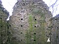
[[File:Cholera pit site, Barrmill.JPG|thumb|200px|left|Detail of the site of the old Cholera pit below South Barr farm, known locally as the 'Dead mans planton'.]] |
[[File:Cholera pit site, Barrmill.JPG|thumb|200px|left|Detail of the site of the old Cholera pit below South Barr farm, known locally as the 'Dead mans planton'.]] |
||
Revision as of 19:23, 23 January 2011

Barrmill is a small village in North Ayrshire, Scotland about a mile and a half a mile east of Beith on the road to Lugton. Locally it is known as the Barr.[1]
History
General Roy's survey of 1747 - 55 shows only the farm of High Barr. A village grew up here due to the employment provided by the several limestone quarries that were present at one time, the Dockra Ironstone pit that was located near the railway line down from Dockra quarry in 1912, and other local industries.


The village that developed had a population of 300 in 1876 and 600 in 1951, when the threadmaking industry had just ceased, although the workers still lived in company houses and were transported daily to the threadmaking factory at Kilbirnie. This mill was founded in the mid-19th century to make linen thread, much used at the time for boot and shoe making, and for sailmaking; an offshoot of the much larger linen thread mills at Kilbirnie. The largest of the mill buildings was a three-storeyed, flat-roofed mill, with a fireproof interior with brick arches on cast iron columns. In front is a section of a range of single-storeyed, north-lit sheds. In 1965 the buildings were being used as a fertiliser factory. The mill buildings have been demolished, but the offices still survive.[2]
The limestone works was closed in 1972. The whinstone quarries of Messrs. King & Co. employed a considerable number of men in 1951, but even then the quarries were almost worked out.[3] Giffen coal pit (No 1) lay close to Bankhead Moss as shown on the 1897 OS map, closing not long afterwards as the following OS maps cease showing it.
The 1912 OS map marks the quoiting ground which was located in what is now the park, close to the old railway embankment; a mission hall is also shown, located just the other side of the railway bridge over the Beith branchline. In 2006 a new housing estate was created on the site of the old Barrmill railway station and goods yard.
The 1890 OS map marks a 'Sout Bar' on the road through Barrmill. This may be the site of a Toll Bar as the name 'Sout' in Scots means a leap, applied when a vehicle leaps up as if struck a hidden stone; possibly a feature of the toll caused this.
Birsieknowe was located in the grounds of what is now DM Beith (2010) and the old coal pit here closed due to flooding beyond the capacity of the pumps in 1913; it had been active in the 1890s. A commemorative plaque was placed at the site.[4][5]
Barrmill Railway station


Barrmill railway station was the only intermediate station on the line from Lugton to Beith Town railway station and opened on 26 June 1873,[6] and closed permanently to passengers on 5 November 1962.[6] Freight services continued on the line until 1964.[7]
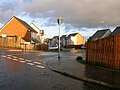
Barrmill village and railway - 2007
-
 The old railway line running towards Lugton at Barmill.
 -
 Approaching Barrmill from Lugton near the old Kilbirnie Junction.
 -
 The old railway bridge over the mainstreet.
 -
 The Station Inn in Barrmill.


-
 Barrmill crossroads, with hotel and shop.
 -
 Barrmill's Community Hall.
 -
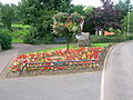 Barrmill's Millennium Garden.
 -
 Barrmill's mainstreet with the railway bridge, looking towards Greenhills.
 -
 Barrmill's park.
 -
 Millbarr Grove on the site of the old station and goodsyard.
 -
 Barrmill's Giffen Mill and the old Miller's house.
 -
 Whisky barrels at the nearby Balgray Bond, Chivas Regal


Bellcraig and Braefoot


Bellcraig House stood near the old entrance to Bogston House and was destroyed by quarrying for whinstone. In 1844 John ritchie of Bellcraigs died.[8] Bellcraig and Crawford Terrace form a small hamlet close to Barrmill. The Braefoot Building stood on the other, north side of the road, owned by Merry & Cunningham the ironmasters. The building was demolished in 1956 and the residents moved to new housing in Beith. The Mack family were onetime residents.[9]
These houses, some of which housed quarry workers, lie close to a 20th century limestone quarry nearby, now abandoned and filled with water. The area had many small limestone and ironstone quarries. Dockra and Broadstone quarries are quite nearby. Around 30 people were employed here in the 1930s.
Cholera outbreak

In the 1830s 40 locals died from cholera and were buried in a triangular 'Cholera pit' plot at the base of Jamesill Hill, south-west of the village. The tradition is that the disease was passed on from a group of gipsies camped on Whin Hill that local boys had gone out to meet. Troops were regularly placed to prevent entry or exit during cholera outbreaks and normal burial in Beith was impossible and impractical, given the number of deaths. The burial site was fenced off and bordered by trees, kept in order by the Crawford Bros. from the factory until they died. It has been neglected since then.[10]
Dockra
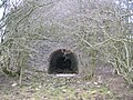
Extensive limestone quarrying took place at Dockra with a mineral line running down to join with the Beith to Lugton line. Limekilns were located at the site, as were gunpowder magazines, a mine manager's house, a large bing, etc. The quarry is now flooded, but not infilled.
-
 The eye of a more recent lime kiln.
 -
 The back of a more recent hat.
 -
 Details of the lock on the gunpoder magazine
 -
 Internal details of the gunpowder magazine.


An ironstone quarry was also located at the site and the ore, crushed on site, was taken down the 'bogey line' via Brackenhills railway station on the Glasgow & South Western railway line to the old Glengarnock steelworks, owned by the Glengarnock Iron & Steel Co.Ltd.[11] The works closed in 1921, however the waste bings remained for many years.[4] The 'Beith Supplement and Advertiser' reported in 1912 that after a two month long strike at Glengarnock Steelworks the ironstone works at Dockra would be re-opening.[12]
DM Beith


A large Defence Munitions (DM) centre is located near Barrmill. The site was originally developed in 1943 as a conventional Royal Naval Armaments Depot, munitions store, for the Royal Navy. It now processes and stores Spearfish, Storm Shadow, Tomahawk and Brimstone missiles. The railway is no longer used for transporting items to the centre.[13]
There were five farms which were taken over by the Ministry of Defence for them to establish the Royal Naval Armaments Depot. Boyd's of Drumbuie, Jacks o' the Ward; Crawfords o' the Scoup; Harpers o' the White Spot; and Blairs of the Bugstone, Boyd of the Bellcraig, Gillies of Gatend and a number of railworkers and farm workers who lived in Patrick Row which was located on Barkip Road near to what is now the main entrance to the depot. In 1942 something like 1,200 acres (4.9 km2) taken to establish the depot.[14]
Drumbuie
Drumbuie House, built in 1702, is one of the oldest inhabited houses in the Beith area and has been the home of the Boyd family for at least three generations.[14] Drumbuie was part of the Barony of Giffen and was feud out to various local millers and farmers in the 17th-century.[15] Close records that Drumbuie Farm incorporates an early 18th-century two storey house, originally thatched, which was built around 1736 for Hugh Patrick, this being stated on a plaque on the 1815 addition.[16]
-
 The old Cotter's House at Drumbuie.
 -
 Drumbuie Farm steading.
 -
 Drumbuie House.


Bankhead Moss

This is a good example of a lowland raised bog or mire. Bankhead is a Site of Special Scientific Interest (SSSI) and a Special Area of Conservation (SAC), making it significant in the European context.
The moss lies entirely within the DM Beith site and therefore access is restricted. Giffen Colliery, bing and freight railway line were once located on the southern side of the moss as shown by the old OS maps of the area; a railway also cut across the northern edge of the moss, however the main part of the moss has been largely untouched by industry although it is grazed by farm animals. The site is monitored by Scottish Natural Heritage (SNH).
Matthew Anderson
Matthew, known as the 'Policemen-Poet of Ayrshire', was posted to Barrmill for a number of years, leaving for Kilmarnock in June 1896. He wrote a number of poems about the district, such as 'Farewell to Barrmill', 'The Braes o'Barrmill', and 'Night at Barrmill.' [1]
Micro-history

The news that the war in South Africa has at last been brought to an end by the surrender of the Boers was known in Barrmill in June 1902 when the early papers arrived. At Barrmill the villagers gave full vent to their joy by knocking off at the breakfast hour and compelling the master at Greenhills to set the scholars free.[17]
The 'Dusk Rovers' were a local football team that played on a pitch located on a field; allowing the ploy of losing the ball into the Dusk Water or onto the nearby railway if the game was not going well.[18]
The Giffen railway viaduct was demolished in the 1980s; locals knew it as the 'Navvies Brig'.
In 2010 a Barrmill Communities Projects Initiatives (BCPI) group was set up by the Community Association and the NAC Ranger Service to improve the appearance of the Barrmill, Greenhills, and Burnhouse villages.
The Black Loch was a shallow loch situated near Nettlehurst House and it was once used for curling. The site was filled with earth and is now overgrown.[19]
See also
- Broadstone Castle and Barony, Ayrshire
- Barony and Castle of Giffen
- Speir's school History of Broadstone
- Giffen railway station
References
- ^ a b Reid, Donald L. (2009). Discovering Matthew Anderson. Policeman-Poet of Ayrshire. Beith : Cleland Crosbie. ISBN 0-9522720-9-1. P. 49
- ^ Barr Mill Linen Thread mill. Accessed : 2009-11-19
- ^ Strawhorn, John and Boyd, William (1951). The Third Statistical Account of Scotland. Ayrshire. Pub. P. 407.
- ^ a b Reid, Donald L. & Monahan, Isobel F. (1999). Yesterday's Beith. A Pictorial Guide. Beith : Duke of Edinburgh Award. ISBN 0-9522720-5-9. P. 57
- ^ Reid, Donald L. (2000). The Story of Beith's Newspaper. Beith : Duke of Edinburgh Award. ISBN 0-9522720-1-6 p. 54.
- ^ a b Butt, R.V.J. (1995). The Directory of Railway Stations: details every public and private passenger station, halt, platform and stopping place, past and present, 1st Edition, Sparkford: Patrick Stephens Ltd. ISBN 1-8526-0508-1.
- ^ Stansfield, G. (1999). Ayrshire & Renfrewshire's Lost Railways. Ochiltree: Stenlake Publishing. ISBN 1-8403-3077-5. P. 10
- ^ The High Church. A Illustrated Guide. 1983, p. 48
- ^ Reid, Donald L. Old Beith. Ochiltree:Stenlake Publishing. ISBN 1-84033-1267. Page 43
- ^ Porterfield, S. (1925). Rambles Round Beith. Beith : Pilot Press. p. 35.
- ^ Gibson, Fergus (2005-6). The freight business of the G&SWR at the start of the 20th Century. Sou' West Journal. No. 37. P. 6
- ^ Reid, Donald L. (2000). The Story of Beith's Newspaper. Beith : Duke of Edinburgh Award. ISBN 0-9522720-1-6 p. 77.
- ^ DM Beith
- ^ a b Recollections of Robert Boyd of Drumbuie. Cite error: The named reference "Boyd" was defined multiple times with different content (see the help page).
- ^ Dobie, James (1876). Pont's Cunninghame topographized 1604-1608 with continuations and illustrative notices (1876). Pub. John Tweed. P.125.
- ^ Close, Robert (1992), Ayrshire and Arran: An Illustrated Architectural Guide. Pub. Royal Incorp Archit Scotland. ISBN. 1873190-06-9. P. 97.
- ^ End of Boer War
- ^ Gilbert, Tom & Grace (2010). Windyhouse Farm.
- ^ Jamieson, Sheila (1997). Our Village. Greenhills Womens' Institute. p. 27
External links
55°43′43″N 4°36′01″W / 55.7286°N 4.6003°W