
Diessenhofen: Difference between revisions
m robot Adding: war:Diessenhofen |
added demographics and geography |
||
| Line 3: | Line 3: | ||
| municipality_name = Diessenhofen |
| municipality_name = Diessenhofen |
||
| municipality_type = municipality |
| municipality_type = municipality |
||
| image_photo = Diessenhofen-01.jpg |
|||
| image_caption = Diessenhofen |
|||
| imagepath_coa = 98px-Diessenhofen.gif|pixel_coa= |
| imagepath_coa = 98px-Diessenhofen.gif|pixel_coa= |
||
| map = |
| map = |
||
| Line 12: | Line 14: | ||
| postal_code = 8253 |
| postal_code = 8253 |
||
| municipality_code = 4545 |
| municipality_code = 4545 |
||
| area = 10. |
| area = 10.12 |
||
| elevation = 397|elevation_description= |
| elevation = 397|elevation_description= |
||
| population = 3160|populationof = December 2007 | popofyear = 2007 |
| population = 3160|populationof = December 2007 | popofyear = 2007 |
||
| Line 26: | Line 28: | ||
'''Diessenhofen''' is a [[Municipalities of Switzerland|municipality]] in the district of [[Diessenhofen (district)|Diessenhofen]] in the [[Cantons of Switzerland|canton]] of [[Thurgau]] in [[Switzerland]]. |
'''Diessenhofen''' is a [[Municipalities of Switzerland|municipality]] in the district of [[Diessenhofen (district)|Diessenhofen]] in the [[Cantons of Switzerland|canton]] of [[Thurgau]] in [[Switzerland]]. |
||
==History== |
|||
| ⚫ | |||
| ⚫ | |||
==Geography== |
|||
| ⚫ | |||
[[File:2006-10-30 10-26-49 Switzerland Schaffhausen Riet.jpg|thumb|left|Aerial view of Diessenhofen on the right side of the Rhine River]] |
|||
Diessenhofen has an area, {{as of|2009|lc=on}}, of {{km2 to mi2|10.12}}. Of this area, {{km2 to mi2|4.24|abbr=yes}} or 41.9% is used for agricultural purposes, while {{km2 to mi2|3.67|abbr=yes}} or 36.3% is forested. Of the rest of the land, {{km2 to mi2|1.62|abbr=yes}} or 16.0% is settled (buildings or roads), {{km2 to mi2|0.51|abbr=yes}} or 5.0% is either rivers or lakes.<ref name=BFS_land>[http://www.bfs.admin.ch/bfs/portal/de/index/themen/02/03/blank/data/gemeindedaten.html Swiss Federal Statistical Office-Land Use Statistics] 2009 data {{de icon}} accessed 25 March 2010</ref> |
|||
Of the built up area, industrial buildings made up 5.3% of the total area while housing and buildings made up 1.8% and transportation infrastructure made up 1.8%. Power and water infrastructure as well as other special developed areas made up 1.3% of the area while parks, green belts and sports fields made up 5.8%. Out of the forested land, 33.9% of the total land area is heavily forested and 2.4% is covered with orchards or small clusters of trees. Of the agricultural land, 40.9% is used for growing crops. All the water in the municipality is flowing water.<ref name=BFS_land/> |
|||
==Location== |
|||
The municipality borders on the west and north with [[Germany]] and the canton of [[Schaffhausen (canton)|Schaffhausen]]. On the east is the district of [[Steckborn (district)|Steckborn]], on the southeast, the municipality of [[Schlatt bei Diessenhofen]], and on the south the municipality of [[Basadingen-Schlattingen]]. |
The municipality borders on the west and north with [[Germany]] and the canton of [[Schaffhausen (canton)|Schaffhausen]]. On the east is the district of [[Steckborn (district)|Steckborn]], on the southeast, the municipality of [[Schlatt bei Diessenhofen]], and on the south the municipality of [[Basadingen-Schlattingen]]. |
||
| Line 48: | Line 54: | ||
|} |
|} |
||
==Demographics== |
|||
[[Image:Diessenhofen2.jpg|thumb |
[[Image:Diessenhofen2.jpg|thumb|In Diessenhofen]] |
||
Diessenhofen has a population ({{as of|{{Swiss populations YM|CH-TG}}|lc=on}}) of {{Swiss populations|CH-TG|4545}}{{Swiss populations ref|CH-TG}} {{as of|2008}}, 30.7% of the population are foreign nationals.<ref name=HDS_superweb>[http://www.bfs.admin.ch/bfs/portal/de/index/infothek/onlinedb/superweb/login.html Swiss Federal Statistical Office - Superweb database - Gemeinde Statistics 1981-2008] {{de icon}} accessed 19 June 2010</ref> Over the last 10 years (1997-2007) the population has changed at a rate of 1.5%. Most of the population ({{as of|2000|lc=on}}) speaks [[German language|German ]](81.8%), with [[Italian language|Italian]] being second most common ( 5.2%) and [[Albanian language|Albanian]] being third ( 3.9%).<ref name=SFSO>[http://www.bfs.admin.ch/bfs/portal/en/index/regionen/regionalportraets/gemeindesuche.html Swiss Federal Statistical Office] accessed 13-September-2010</ref> |
|||
{{as of|2008}}, the gender distribution of the population was 50.7% male and 49.3% female. The population was made up of 1,088 Swiss men (33.4% of the population), and 564 (17.3%) non-Swiss men. There were 1,171 Swiss women (35.9%), and 437 (13.4%) non-Swiss women.<ref name=HDS_superweb>[http://www.bfs.admin.ch/bfs/portal/de/index/infothek/onlinedb/superweb/login.html Swiss Federal Statistical Office - Superweb database - Gemeinde Statistics 1981-2008] {{de icon}} accessed 19 June 2010</ref> |
|||
In {{as of|2008|alt=2008}} there were 23 live births to Swiss citizens and 14 births to non-Swiss citizens, and in same time span there were 17 deaths of Swiss citizens and 3 non-Swiss citizen deaths. Ignoring immigration and emigration, the population of Swiss citizens increased by 6 while the foreign population increased by 11. There were 4 Swiss men who emigrated from Switzerland to another country, 2 Swiss women who emigrated from Switzerland to another country, 34 non-Swiss men who emigrated from Switzerland to another country and 28 non-Swiss women who emigrated from Switzerland to another country. The total Swiss population change in 2008 (from all sources) was an increase of 25 and the non-Swiss population change was an increase of 32 people. This represents a [[Population growth#Population growth rate|population growth rate]] of 1.8%.<ref name=HDS_superweb/> |
|||
The age distribution, {{as of|2009|lc=on}}, in Diessenhofen is; 297 children or 9.0% of the population are between 0 and 9 years old and 384 teenagers or 11.6% are between 10 and 19. Of the adult population, 430 people or 13.0% of the population are between 20 and 29 years old. 460 people or 13.9% are between 30 and 39, 516 people or 15.6% are between 40 and 49, and 472 people or 14.2% are between 50 and 59. The senior population distribution is 418 people or 12.6% of the population are between 60 and 69 years old, 224 people or 6.8% are between 70 and 79, there are 99 people or 3.0% who are between 80 and 89, and there are 14 people or 0.4% who are 90 and older.<ref>[http://www.statistik.tg.ch/xml_8/internet/de/application/d10460/d10631/f10493.cfm Statistical Office of Thurgau], MS Excel document – ''Altersstruktur der Wohnbevölkerung nach zivilrechtlichem Wohnsitzbegriff am 31.12.2009'' {{de icon}} accessed 23 June 2010</ref> |
|||
{{as of|2000}} the average number of residents per living room was 0.58 which is about equal to the cantonal average of 0.56 per room. In this case, a room is defined as space of a housing unit of at least {{m2 to ft2|4|abbr=yes|precision=-1}} as normal bedrooms, dining rooms, living rooms, kitchens and habitable cellars and attics.<ref>{{cite manual | author = Eurostat| title = Urban Audit Glossary| section = Housing (SA1)| version = 2007| url = http://www.bfs.admin.ch/bfs/portal/en/index/international/22/lexi.Document.116365.pdf |format = pdf | page= 18| accessdate = 12 February 2010 }}</ref> About 33.7% of the total households were owner occupied, or in other words did not pay rent (though they may have a [[Mortgage loan|mortgage]] or a [[rent-to-own]] agreement).<ref>Urban Audit Glossary pg 17</ref> |
|||
{{as of|2000}}, there were 1,325 private households in the municipality, and an average of 2.4 persons per household.<ref name=SFSO/> {{as of|2000|alt=In 2000}} there were 338 single family homes (or 67.1% of the total) out of a total of 504 inhabited buildings. There were 46 two family buildings (9.1%), 36 three family buildings (7.1%) and 84 multi-family buildings (or 16.7%).<ref>[http://www.statistik.tg.ch/xml_8/internet/de/application/d10477/d10644/f10481.cfm Statistical Office of Thurgau], MS Excel document - ''Wohngebäude nach Anzahl Wohneinheiten und Gemeinden, Jahr 2000'' {{de icon}} accessed 24 June 2010</ref> There were 732 (or 22.7%) persons who were part of a couple without children, and 1,722 (or 53.4%) who were part of a couple with children. There were 175 (or 5.4%) people who lived in single parent home, while there are 6 persons who were adult children living with one or both parents, 9 persons who lived in a household made up of relatives, 23 who lived in a household made up of unrelated persons, and 107 who are either institutionalized or live in another type of collective housing.<ref>[http://www.statistik.tg.ch/xml_8/internet/de/application/d10460/d10632/f10492.cfm Statistical Office of Thurgau], MS Excel document – ''Wohnbevölkerung nach Haushaltstyp und Gemeinde, Jahr 2000'' {{de icon}} accessed 23 June 2010</ref> |
|||
The vacancy rate for the municipality, {{as of|2008|alt=in 2008}}, was 1.72%. {{as of|2007}}, the construction rate of new housing units was 0.6 new units per 1000 residents.<ref name=SFSO/> {{as of|2000|alt=In 2000}} there were 1,528 apartments in the municipality. The most common apartment size was the 4 room apartment of which there were 471. There were 88 single room apartments and 162 apartments with six or more rooms.<ref name=Zimmer>[http://www.statistik.tg.ch/xml_8/internet/de/application/d10477/d10644/f10481.cfm Statistical Office of Thurgau], MS Excel document - ''Wohnungen nach Anzahl Zimmer und Gemeinden, Jahr 2000'' {{de icon}} accessed 24 June 2010</ref> {{as of|2000}} the average price to rent an average apartment in Diessenhofen was 900.07 [[Swiss franc]]s (CHF) per month (US$720, £410, €580 approx. exchange rate from 2000). The average rate for a one room apartment was 649.00 CHF (US$520, £290, €420), a two room apartment was about 628.34 CHF (US$500, £280, €400), a three room apartment was about 788.98 CHF (US$630, £360, €500) and a six or more room apartment cost an average of 1614.00 CHF (US$1290, £730, €1030). The average apartment price in Diessenhofen was 80.7% of the national average of 1116 CHF.<ref>[http://www.statistik.tg.ch/xml_8/internet/de/application/d10477/d10646/f10556.cfm Statistical Office of Thurgau], MS Excel document - ''Durchschnittlicher Wohnungsmietpreis nach Anzahl Zimmer und Gemeinden'' {{de icon}} accessed 24 June 2010</ref> |
|||
In the 2007 [[Swiss federal election, 2007|federal election]] the most popular party was the [[Swiss People's Party|SVP]] which received 43.96% of the vote. The next three most popular parties were the [[Social Democratic Party of Switzerland|SP]] (16.98%), the [[Christian Democratic People's Party of Switzerland|CVP]] (12.61%) and the [[Free Democratic Party of Switzerland|FDP]] (11.63%). In the federal election, a total of 909 votes were cast, and the [[voter turnout]] was 47.3%.<ref>[http://www.bfs.admin.ch/bfs/portal/de/index/themen/17/02/blank/data/04/03.html Swiss Federal Statistical Office, ''Nationalratswahlen 2007: Stärke der Parteien und Wahlbeteiligung, nach Gemeinden/Bezirk/Canton''] {{de icon}} accessed 28 May 2010</ref> |
|||
The historical population is given in the following table:<ref name=HDS>{{HDS|1891|Diessenhofen}}</ref> |
|||
{| class="wikitable" |
|||
|- |
|||
! year |
|||
! population |
|||
|- |
|||
| 1527 |
|||
| ca 1,000 |
|||
|- |
|||
| 1850 |
|||
| 1,616 |
|||
|- |
|||
| 1900 |
|||
| 1,876 |
|||
|- |
|||
| 1950 |
|||
| 2,608 |
|||
|- |
|||
| 1990 |
|||
| 3,292 |
|||
|- |
|||
| 2000 |
|||
| 3,227 |
|||
|- |
|||
|} |
|||
==Heritage sites of national significance== |
|||
[[Unterhof Castle]], City Archives in the [[Rathaus]] (Town council house), Former [[Dominican Order|Dominican]] Monastery of St. Katharinental with its granary, the ''zum Goldenen Löwen'' House and the ''Goldener Leuen'' Collection, the ''Rheinbrücke'' ([[Rhine]] Bridge), and the city walls with ''Siegelturm'' are listed as Swiss [[Swiss inventory of cultural property of national and regional significance|heritage site of national significance]]. Both the town of Diessenhofen and St Katharinental Monastery are part of the [[Inventory of Swiss Heritage Sites]].<ref>{{cite web|url=http://www.bevoelkerungsschutz.admin.ch/internet/bs/de/home/themen/kgs/kgs_inventar/a-objekte.parsys.000106.DownloadFile.tmp/tg.pdf|title=Kantonsliste A-Objekte: Thurgau|year=2009|work=[http://www.bevoelkerungsschutz.admin.ch/internet/bs/de/home/themen/kgs/kgs_inventar.html KGS Inventar]|publisher=Federal Office of Civil Protection|language=German|accessdate=28 November 2009}}</ref> |
|||
<gallery> |
|||
File:BrückeDiessenhofen.JPG|Rhine Bridge |
|||
| ⚫ | |||
File:2009-02-15 St Katharinental 02.jpg|St. Katharinental Monastery |
|||
</gallery> |
|||
== Architecture == |
== Architecture == |
||
The ''Altstadt'' of Diessenhofen centers on the ''Siegelturm'' a tower in which seals and official documents are kept. The old covered bridge over the Rhine was rebuilt in 1814. It leads to [[Gailingen am Hochrhein]] in [[Baden-Württemberg]] in Germany. |
The ''Altstadt'' of Diessenhofen centers on the ''Siegelturm'' a tower in which seals and official documents are kept. The old covered bridge over the Rhine was rebuilt in 1814. It leads to [[Gailingen am Hochrhein]] in [[Baden-Württemberg]] in Germany. |
||
[[Image:Diessenhofen3.jpg|thumb |
[[Image:Diessenhofen3.jpg|thumb|Rhine bridge]] |
||
==Economy== |
|||
{{as of|2007|In 2007}}, Diessenhofen had an unemployment rate of 1.59%. {{as of|2005}}, there were 74 people employed in the [[Primary sector of the economy|primary economic sector]] and about 25 businesses involved in this sector. 668 people are employed in the [[Secondary sector of the economy|secondary sector]] and there are 54 businesses in this sector. 901 people are employed in the [[Tertiary sector of the economy|tertiary sector]], with 143 businesses in this sector.<ref name=SFSO/> |
|||
{{as of|2000|alt=In 2000}} there were 2,220 workers who lived in the municipality. Of these, 964 or about 43.4% of the residents worked outside Diessenhofen while 967 people commuted into the municipality for work. There were a total of 2,223 jobs (of at least 6 hours per week) in the municipality.<ref>[http://www.media-stat.admin.ch/stat/pendler/pop.php Swiss Federal Statistical Office - Statweb] {{de icon}} accessed 24 June 2010</ref> Of the working population, 12.7% used public transportation to get to work, and 44.7% used a private car.<ref name=SFSO/> |
|||
==Religion== |
|||
From the {{as of|2000|alt=2000 census}}, 955 or 29.6% were [[Roman Catholic]], while 1,335 or 41.4% belonged to the [[Swiss Reformed Church]]. Of the rest of the population, there were 3 Old Catholics (or about 0.09% of the population) who belonged to the [[Christian Catholic Church of Switzerland]] there are 98 individuals (or about 3.04% of the population) who belong to the [[Orthodox Church]], and there are 96 individuals (or about 2.97% of the population) who belong to another Christian church. There were 3 individuals (or about 0.09% of the population) who were [[Judaism|Jewish]], and 318 (or about 9.85% of the population) who are [[Islam]]ic. There are 11 individuals (or about 0.34% of the population) who belong to another church (not listed on the census), 269 (or about 8.34% of the population) belong to no church, are [[Agnosticism|agnostic]] or [[Atheism|atheist]], and 139 individuals (or about 4.31% of the population) did not answer the question.<ref>[http://www.statistik.tg.ch/xml_8/internet/de/application/d10460/d10631/f10494.cfm Statistical Office of Thurgau], MS Excel document – ''Wohnbevölkerung Gemeinden nach religiöser Zugehörigkeit, Jahr 2000'' {{de icon}} accessed 23 June 2010</ref> |
|||
==Education== |
|||
The entire Swiss population is generally well educated. In Diessenhofen about 66.5% of the population (between age 25-64) have completed either non-mandatory [[Education in Switzerland#Secondary|upper secondary education]] or additional higher education (either University or a ''[[Fachhochschule]]'').<ref name=SFSO/> |
|||
Diessenhofen is home to the Diessenhofen [[Education in Switzerland|primary and secondary school district]].In the 2008/2009 school year there are 691 students at either the primary or secondary levels. There are 131 children in the [[kindergarten]], and the average class size is 18.71 kindergartners. Of the children in kindergarten, 63 or 48.1% are female, 32 or 24.4% are not Swiss citizens and 30 or 22.9% do not speak German natively. The lower and upper primary levels begin at about age 5-6 and lasts for 6 years. There are 200 children in who are at the lower primary level and 236 children in the upper primary level. The average class size in the primary school is 20.1 students. At the lower primary level, there are 93 children or 46.5% of the total population who are female, 52 or 26.0% are not Swiss citizens and 48 or 24.0% do not speak German natively. In the upper primary level, there are 100 or 42.4% who are female, 59 or 25.0% are not Swiss citizens and 63 or 26.7% do not speak German natively. At the secondary level, students are divided according to performance. |
|||
The secondary level begins at about age 12 and usually lasts 3 years. There are 220 teenagers who are in the advanced school, of which 125 or 56.8% are female, 45 or 20.5% are not Swiss citizens and 41 or 18.6% do not speak German natively. There are 19 teenagers who are in the standard school, of which 8 or 42.1% are female, 5 or 26.3% are not Swiss citizens and 5 or 26.3% do not speak German natively. Finally, there are 16 teenagers who are in special or remedial classes, of which 6 or 37.5% are female, 8 or 50.0% are not Swiss citizens and 8 or 50.0% do not speak German natively. The average class size for all classes at the secondary level is 19.92 students.<ref>[http://www.bista.tg.ch/pub/TG_pu.aspx Canton Thurgau Schools] {{De icon}} accessed 23 June 2010</ref> |
|||
==References== |
==References== |
||
| Line 68: | Line 139: | ||
[[Category:Municipalities of Thurgau]] |
[[Category:Municipalities of Thurgau]] |
||
[[Category:Imperial free cities]] |
[[Category:Imperial free cities]] |
||
[[Category:Cultural property of national significance in the canton of Thurgau]] |
|||
{{Thurgau-geo-stub}} |
|||
[[ca:Diessenhofen]] |
[[ca:Diessenhofen]] |
||
Revision as of 13:43, 13 September 2010
Diessenhofen | |
|---|---|
 Diessenhofen | |
|
Coat of arms of Diessenhofen Coat of arms | |
Location of Diessenhofen  | |
| Country | Switzerland |
| Canton | Thurgau |
| District | Diessenhofen |
| Area | |
| • Total | 10.0 km2 (3.9 sq mi) |
| Elevation | 397 m (1,302 ft) |
| Population (31 December 2018)[2] | |
| • Total | 3,998 |
| • Density | 400/km2 (1,000/sq mi) |
| Time zone | UTC+01:00 (Central European Time) |
| • Summer (DST) | UTC+02:00 (Central European Summer Time) |
| Postal code(s) | 8253 |
| SFOS number | 4545 |
| ISO 3166 code | CH-TG |
| Localities | Willisdorf |
| Surrounded by | Schlatt bei Diessenhofen, Basadingen-Schlattingen |
| Website | www SFSO statistics |
Diessenhofen is a municipality in the district of Diessenhofen in the canton of Thurgau in Switzerland.
History
Diessenhofen is first mentioned in 757 as Deozincova.[3] In 2000, the village of Willisdorf was incorporated into the municipality.
Geography

Diessenhofen has an area, as of 2009[update], of Template:Km2 to mi2. Of this area, Template:Km2 to mi2 or 41.9% is used for agricultural purposes, while Template:Km2 to mi2 or 36.3% is forested. Of the rest of the land, Template:Km2 to mi2 or 16.0% is settled (buildings or roads), Template:Km2 to mi2 or 5.0% is either rivers or lakes.[4]
Of the built up area, industrial buildings made up 5.3% of the total area while housing and buildings made up 1.8% and transportation infrastructure made up 1.8%. Power and water infrastructure as well as other special developed areas made up 1.3% of the area while parks, green belts and sports fields made up 5.8%. Out of the forested land, 33.9% of the total land area is heavily forested and 2.4% is covered with orchards or small clusters of trees. Of the agricultural land, 40.9% is used for growing crops. All the water in the municipality is flowing water.[4]
The municipality borders on the west and north with Germany and the canton of Schaffhausen. On the east is the district of Steckborn, on the southeast, the municipality of Schlatt bei Diessenhofen, and on the south the municipality of Basadingen-Schlattingen.
| Germany | Canton of Schaffhausen | Germany |
| Germany | 
|
District of Steckborn |
| Schlatt bei Diessenhofen | Basadingen-Schlattingen | Basadingen-Schlattingen |
Demographics

Diessenhofen has a population (as of December 2020[update]) of 4,085[5] As of 2008[update], 30.7% of the population are foreign nationals.[6] Over the last 10 years (1997-2007) the population has changed at a rate of 1.5%. Most of the population (as of 2000[update]) speaks German (81.8%), with Italian being second most common ( 5.2%) and Albanian being third ( 3.9%).[7]
As of 2008[update], the gender distribution of the population was 50.7% male and 49.3% female. The population was made up of 1,088 Swiss men (33.4% of the population), and 564 (17.3%) non-Swiss men. There were 1,171 Swiss women (35.9%), and 437 (13.4%) non-Swiss women.[6]
In 2008[update] there were 23 live births to Swiss citizens and 14 births to non-Swiss citizens, and in same time span there were 17 deaths of Swiss citizens and 3 non-Swiss citizen deaths. Ignoring immigration and emigration, the population of Swiss citizens increased by 6 while the foreign population increased by 11. There were 4 Swiss men who emigrated from Switzerland to another country, 2 Swiss women who emigrated from Switzerland to another country, 34 non-Swiss men who emigrated from Switzerland to another country and 28 non-Swiss women who emigrated from Switzerland to another country. The total Swiss population change in 2008 (from all sources) was an increase of 25 and the non-Swiss population change was an increase of 32 people. This represents a population growth rate of 1.8%.[6]
The age distribution, as of 2009[update], in Diessenhofen is; 297 children or 9.0% of the population are between 0 and 9 years old and 384 teenagers or 11.6% are between 10 and 19. Of the adult population, 430 people or 13.0% of the population are between 20 and 29 years old. 460 people or 13.9% are between 30 and 39, 516 people or 15.6% are between 40 and 49, and 472 people or 14.2% are between 50 and 59. The senior population distribution is 418 people or 12.6% of the population are between 60 and 69 years old, 224 people or 6.8% are between 70 and 79, there are 99 people or 3.0% who are between 80 and 89, and there are 14 people or 0.4% who are 90 and older.[8]
As of 2000[update] the average number of residents per living room was 0.58 which is about equal to the cantonal average of 0.56 per room. In this case, a room is defined as space of a housing unit of at least Template:M2 to ft2 as normal bedrooms, dining rooms, living rooms, kitchens and habitable cellars and attics.[9] About 33.7% of the total households were owner occupied, or in other words did not pay rent (though they may have a mortgage or a rent-to-own agreement).[10]
As of 2000[update], there were 1,325 private households in the municipality, and an average of 2.4 persons per household.[7] In 2000[update] there were 338 single family homes (or 67.1% of the total) out of a total of 504 inhabited buildings. There were 46 two family buildings (9.1%), 36 three family buildings (7.1%) and 84 multi-family buildings (or 16.7%).[11] There were 732 (or 22.7%) persons who were part of a couple without children, and 1,722 (or 53.4%) who were part of a couple with children. There were 175 (or 5.4%) people who lived in single parent home, while there are 6 persons who were adult children living with one or both parents, 9 persons who lived in a household made up of relatives, 23 who lived in a household made up of unrelated persons, and 107 who are either institutionalized or live in another type of collective housing.[12]
The vacancy rate for the municipality, in 2008[update], was 1.72%. As of 2007[update], the construction rate of new housing units was 0.6 new units per 1000 residents.[7] In 2000[update] there were 1,528 apartments in the municipality. The most common apartment size was the 4 room apartment of which there were 471. There were 88 single room apartments and 162 apartments with six or more rooms.[13] As of 2000[update] the average price to rent an average apartment in Diessenhofen was 900.07 Swiss francs (CHF) per month (US$720, £410, €580 approx. exchange rate from 2000). The average rate for a one room apartment was 649.00 CHF (US$520, £290, €420), a two room apartment was about 628.34 CHF (US$500, £280, €400), a three room apartment was about 788.98 CHF (US$630, £360, €500) and a six or more room apartment cost an average of 1614.00 CHF (US$1290, £730, €1030). The average apartment price in Diessenhofen was 80.7% of the national average of 1116 CHF.[14]
In the 2007 federal election the most popular party was the SVP which received 43.96% of the vote. The next three most popular parties were the SP (16.98%), the CVP (12.61%) and the FDP (11.63%). In the federal election, a total of 909 votes were cast, and the voter turnout was 47.3%.[15]
The historical population is given in the following table:[3]
| year | population |
|---|---|
| 1527 | ca 1,000 |
| 1850 | 1,616 |
| 1900 | 1,876 |
| 1950 | 2,608 |
| 1990 | 3,292 |
| 2000 | 3,227 |
Heritage sites of national significance
Unterhof Castle, City Archives in the Rathaus (Town council house), Former Dominican Monastery of St. Katharinental with its granary, the zum Goldenen Löwen House and the Goldener Leuen Collection, the Rheinbrücke (Rhine Bridge), and the city walls with Siegelturm are listed as Swiss heritage site of national significance. Both the town of Diessenhofen and St Katharinental Monastery are part of the Inventory of Swiss Heritage Sites.[16]
-
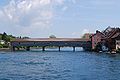 Rhine Bridge
 -
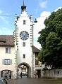 Siegelturm
 -
 St. Katharinental Monastery


Architecture
The Altstadt of Diessenhofen centers on the Siegelturm a tower in which seals and official documents are kept. The old covered bridge over the Rhine was rebuilt in 1814. It leads to Gailingen am Hochrhein in Baden-Württemberg in Germany.

Economy
As of 2007[update], Diessenhofen had an unemployment rate of 1.59%. As of 2005[update], there were 74 people employed in the primary economic sector and about 25 businesses involved in this sector. 668 people are employed in the secondary sector and there are 54 businesses in this sector. 901 people are employed in the tertiary sector, with 143 businesses in this sector.[7]
In 2000[update] there were 2,220 workers who lived in the municipality. Of these, 964 or about 43.4% of the residents worked outside Diessenhofen while 967 people commuted into the municipality for work. There were a total of 2,223 jobs (of at least 6 hours per week) in the municipality.[17] Of the working population, 12.7% used public transportation to get to work, and 44.7% used a private car.[7]
Religion
From the 2000 census[update], 955 or 29.6% were Roman Catholic, while 1,335 or 41.4% belonged to the Swiss Reformed Church. Of the rest of the population, there were 3 Old Catholics (or about 0.09% of the population) who belonged to the Christian Catholic Church of Switzerland there are 98 individuals (or about 3.04% of the population) who belong to the Orthodox Church, and there are 96 individuals (or about 2.97% of the population) who belong to another Christian church. There were 3 individuals (or about 0.09% of the population) who were Jewish, and 318 (or about 9.85% of the population) who are Islamic. There are 11 individuals (or about 0.34% of the population) who belong to another church (not listed on the census), 269 (or about 8.34% of the population) belong to no church, are agnostic or atheist, and 139 individuals (or about 4.31% of the population) did not answer the question.[18]
Education
The entire Swiss population is generally well educated. In Diessenhofen about 66.5% of the population (between age 25-64) have completed either non-mandatory upper secondary education or additional higher education (either University or a Fachhochschule).[7]
Diessenhofen is home to the Diessenhofen primary and secondary school district.In the 2008/2009 school year there are 691 students at either the primary or secondary levels. There are 131 children in the kindergarten, and the average class size is 18.71 kindergartners. Of the children in kindergarten, 63 or 48.1% are female, 32 or 24.4% are not Swiss citizens and 30 or 22.9% do not speak German natively. The lower and upper primary levels begin at about age 5-6 and lasts for 6 years. There are 200 children in who are at the lower primary level and 236 children in the upper primary level. The average class size in the primary school is 20.1 students. At the lower primary level, there are 93 children or 46.5% of the total population who are female, 52 or 26.0% are not Swiss citizens and 48 or 24.0% do not speak German natively. In the upper primary level, there are 100 or 42.4% who are female, 59 or 25.0% are not Swiss citizens and 63 or 26.7% do not speak German natively. At the secondary level, students are divided according to performance.
The secondary level begins at about age 12 and usually lasts 3 years. There are 220 teenagers who are in the advanced school, of which 125 or 56.8% are female, 45 or 20.5% are not Swiss citizens and 41 or 18.6% do not speak German natively. There are 19 teenagers who are in the standard school, of which 8 or 42.1% are female, 5 or 26.3% are not Swiss citizens and 5 or 26.3% do not speak German natively. Finally, there are 16 teenagers who are in special or remedial classes, of which 6 or 37.5% are female, 8 or 50.0% are not Swiss citizens and 8 or 50.0% do not speak German natively. The average class size for all classes at the secondary level is 19.92 students.[19]
References
- ^ a b "Arealstatistik Standard - Gemeinden nach 4 Hauptbereichen". Federal Statistical Office. Retrieved 13 January 2019.
- ^ "Ständige Wohnbevölkerung nach Staatsangehörigkeitskategorie Geschlecht und Gemeinde; Provisorische Jahresergebnisse; 2018". Federal Statistical Office. 9 April 2019. Retrieved 11 April 2019.
- ^ a b Diessenhofen in German, French and Italian in the online Historical Dictionary of Switzerland.
- ^ a b Swiss Federal Statistical Office-Land Use Statistics 2009 data Template:De icon accessed 25 March 2010
- ^ "Ständige und nichtständige Wohnbevölkerung nach institutionellen Gliederungen, Geburtsort und Staatsangehörigkeit". bfs.admin.ch (in German). Swiss Federal Statistical Office - STAT-TAB. 31 December 2020. Retrieved 21 September 2021.
- ^ a b c Swiss Federal Statistical Office - Superweb database - Gemeinde Statistics 1981-2008 Template:De icon accessed 19 June 2010
- ^ a b c d e f Swiss Federal Statistical Office accessed 13-September-2010
- ^ Statistical Office of Thurgau, MS Excel document – Altersstruktur der Wohnbevölkerung nach zivilrechtlichem Wohnsitzbegriff am 31.12.2009 Template:De icon accessed 23 June 2010
- ^ Eurostat. "Housing (SA1)". Urban Audit Glossary (pdf). 2007. p. 18. Retrieved 12 February 2010.
- ^ Urban Audit Glossary pg 17
- ^ Statistical Office of Thurgau, MS Excel document - Wohngebäude nach Anzahl Wohneinheiten und Gemeinden, Jahr 2000 Template:De icon accessed 24 June 2010
- ^ Statistical Office of Thurgau, MS Excel document – Wohnbevölkerung nach Haushaltstyp und Gemeinde, Jahr 2000 Template:De icon accessed 23 June 2010
- ^ Statistical Office of Thurgau, MS Excel document - Wohnungen nach Anzahl Zimmer und Gemeinden, Jahr 2000 Template:De icon accessed 24 June 2010
- ^ Statistical Office of Thurgau, MS Excel document - Durchschnittlicher Wohnungsmietpreis nach Anzahl Zimmer und Gemeinden Template:De icon accessed 24 June 2010
- ^ Swiss Federal Statistical Office, Nationalratswahlen 2007: Stärke der Parteien und Wahlbeteiligung, nach Gemeinden/Bezirk/Canton Template:De icon accessed 28 May 2010
- ^ "Kantonsliste A-Objekte: Thurgau" (PDF). KGS Inventar (in German). Federal Office of Civil Protection. 2009. Retrieved 28 November 2009.
{{cite web}}: External link in|work= - ^ Swiss Federal Statistical Office - Statweb Template:De icon accessed 24 June 2010
- ^ Statistical Office of Thurgau, MS Excel document – Wohnbevölkerung Gemeinden nach religiöser Zugehörigkeit, Jahr 2000 Template:De icon accessed 23 June 2010
- ^ Canton Thurgau Schools Template:De icon accessed 23 June 2010
External links
- Diessenhofen in German, French and Italian in the online Historical Dictionary of Switzerland.