
Cummertrees: Difference between revisions
Rosser1954 (talk | contribs) |
Rosser1954 (talk | contribs) |
||
| Line 3: | Line 3: | ||
==History== |
==History== |
||
{|style="float:right; margin:1em 1em 1em 1em; width:27em; border: 1px solid #a0a0a0; padding: 10px; background-color: #F5F5F5; text-align:right;" |
|||
|- style="text-align:center;" |
|||
|'''Etymology''' |
|||
|- style="text-align:left; font-size:x-medium;" |
|||
|The meaning of Cummertrees is suggested as being 'confluence at the thorn or brambles' from the Gaelic 'Comar dreas'. |
|||
|} |
|||
Cummertrees is [[rural]], primarily [[residential]] village with a name of doubtful etymology. |
Cummertrees is [[rural]], primarily [[residential]] village with a name of doubtful etymology. |
||
The parish includes Powfoot and Trailtrow and is bounded by St Mungo and Hoddam, Annan, the [[Solway Firth]], and Ruthwell and Dalton. A public hall was erected in 1893.<ref name="G327">Groome, Page 327</ref> The river Annan is at the northern boundary. It has a wide area of level sand swept by the Solway 'bore' which can move at around ten miles an hour and can often be heard throughout the parish. The seaboard is low and sandy and features in [[Walter Scott]]'s novel ''[[Redgauntlet]]''. The ground rises a little inland, to 350 feet on Repentance Hill.<ref name="G327">Groome, Page 327</ref> |
The parish includes Powfoot and Trailtrow and is bounded by St Mungo and Hoddam, Annan, the [[Solway Firth]], and Ruthwell and Dalton. A public hall was erected in 1893.<ref name="G327">Groome, Page 327</ref> The river Annan is at the northern boundary. It has a wide area of level sand swept by the Solway 'bore' which can move at around ten miles an hour and can often be heard throughout the parish. The seaboard is low and sandy and features in [[Walter Scott]]'s novel ''[[Redgauntlet]]''. The ground rises a little inland, to 350 feet on Repentance Hill.<ref name="G327">Groome, Page 327</ref> |
||
| Line 10: | Line 16: | ||
In a field called Bruce's Acres, at Broom Farm, [[Robert Bruce]] fought and lost a skirmish against the Southron (English).<ref name="G327">Groome, Page 327</ref> |
In a field called Bruce's Acres, at Broom Farm, [[Robert Bruce]] fought and lost a skirmish against the Southron (English).<ref name="G327">Groome, Page 327</ref> |
||
Cummertrees parish includes some notable buildings, Hoddam Castle, Kinmount and Murraythwaite. Historically, the main landowner has been the [[Marquess of Queensberry]]. The church was founded by Robert Bruce and has been much rebuilt and enlarged.<ref name="G327">Groome, Page 327</ref> |
Cummertrees parish includes some notable buildings, Hoddam Castle, Kinmount and Murraythwaite. Historically, the main landowner has been the [[Marquess of Queensberry]]. The church was founded by Robert Bruce and has been much rebuilt and enlarged.<ref name="G327">Groome, Page 327</ref> |
||
==Views of Cummertrees== |
==Views of Cummertrees== |
||
Revision as of 20:26, 22 March 2010

Cummertrees is a coastal village and parish of Annandale in Dumfries and Galloway. It lies about a mile inland, on the Pow Water, twelve miles from Dumfries, and three from Annan.[1]
History
| Etymology |
| The meaning of Cummertrees is suggested as being 'confluence at the thorn or brambles' from the Gaelic 'Comar dreas'. |
Cummertrees is rural, primarily residential village with a name of doubtful etymology. The parish includes Powfoot and Trailtrow and is bounded by St Mungo and Hoddam, Annan, the Solway Firth, and Ruthwell and Dalton. A public hall was erected in 1893.[1] The river Annan is at the northern boundary. It has a wide area of level sand swept by the Solway 'bore' which can move at around ten miles an hour and can often be heard throughout the parish. The seaboard is low and sandy and features in Walter Scott's novel Redgauntlet. The ground rises a little inland, to 350 feet on Repentance Hill.[1]
The geology is mainly Devonian, with old limestone workings at Kelhead and some sandstone quarries.[1]
In a field called Bruce's Acres, at Broom Farm, Robert Bruce fought and lost a skirmish against the Southron (English).[1]
Cummertrees parish includes some notable buildings, Hoddam Castle, Kinmount and Murraythwaite. Historically, the main landowner has been the Marquess of Queensberry. The church was founded by Robert Bruce and has been much rebuilt and enlarged.[1]
Views of Cummertrees
-
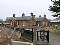 The old Cummertrees railway station.
 -
 The parish church and lychgate.
 -
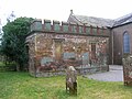 The Douglas family Mausoleum at the Parish Church.
 -
 Holiday appartments at Agnes Hill.


Notable residents

- Lady Florence Dixie (1855-1905), travel writer, war correspondent, and feminist, a daughter of the 8th Marquess of Queensberry, was born and lived much of her later life on the Kinmount estate.
- Lord Francis Douglas (1847 – 14 July 1865) was a British mountaineer born in Cummertrees. After sharing in the first ascent of the Matterhorn, he died in a fall on the way down from the summit
References
Notes
Sources
- Groome, Francis H. (1903). Ordnance Gazetteer of Scotland. London : Caxton Publishing Company.
- Johnston, J. B. (1903). Place-names of Scotland. Edinburgh : David Douglas.
54°59′N 3°21′W / 54.983°N 3.350°W
This Dumfries and Galloway location article is a stub. You can help Wikipedia by expanding it. |