
Eglinton Tournament Bridge: Difference between revisions
Rosser1954 (talk | contribs) |
Rosser1954 (talk | contribs) |
||
| Line 62: | Line 62: | ||
[[Image:Eglinton in 1790.JPG|right|thumb|200px|<Center>John Ainslie's 1790 map showing pleasure garden on the opposite side of the Lugton Water to the castle in what became part of the deer park.]] |
[[Image:Eglinton in 1790.JPG|right|thumb|200px|<Center>John Ainslie's 1790 map showing pleasure garden on the opposite side of the Lugton Water to the castle in what became part of the deer park.]] |
||
Originally the river would have been crossed by simple fords, however by the 18th century ornamental pleasure gardens had been formed and these were partly situated in what later became the deer park. No signs of these gardens are now visible, apart from [[Crop mark]]s on aerial photographs taken around the end of the Second World War. A bridge was necessary to give access and one is indicated on John Ainslie's map dated 1790, crossing the Lugton Water close to the castle itself. A small wooden bridge across the Lugton Water is shown in an illustration from around 1815. |
Originally the river would have been crossed by simple fords, however by the 18th century ornamental pleasure gardens had been formed and these were partly situated in what later became the deer park. No signs of these gardens are now visible, apart from [[Crop mark]]s on aerial photographs taken around the end of the Second World War. A bridge was necessary to give access and one is indicated on John Ainslie's map dated 1790, crossing the Lugton Water close to the castle itself. A small wooden bridge across the Lugton Water is shown in an illustration from around 1815. |
||
[[Image:Stucco stone from footbridge.JPG|right|thumb|200px|<Center>A stone with recessed markings from the ornate footbridge that once crossed the Lugton Water at the kitchen walled garden.]] |
|||
The restored Stables Bridge lies on the Kilwinning Lodge drive and just downstream from it stood a wooden bridge which had high quality stonework on both of the abutments, much of which survive. This bridge gave access to the kitchen walled gardens and glasshouse ranges. The Suspension Bridge built by the army on behalf of the country park lies just below the weir beside the ruined gazebo. Lady Jane's cottage had a wooded pedestrian footbridge of which no sign remains. |
|||
{{Clear}} |
{{Clear}} |
||
Revision as of 14:50, 15 May 2008

The Eglinton Tournament Bridge is situated within Eglinton Country Park which is itself located in the grounds of the old Eglinton Castle estate, Irvine, on the outskirts of Kilwinning, North Ayrshire, Scotland (Map reference: NS 3206 4224). Eglinton Country Park is situated in the parish of Kilwinning, part of the former district of Cunninghame, and covers an area of 400 hectares (988 acres).
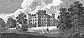
The central iconic feature of the country park is the ruined Eglinton Castle, once home to the Montgomerie family, Earls of Eglinton and chiefs of the Clan Montgomery. A striking architectural feature of the park is the Tournament Bridge which crosses over the Lugton Water.
Location
Eglinton is a one hour drive from Glasgow, accessed via the M77 to Kilmarnock, followed by the A71 to Irvine, and then the A78(T) to Eglinton Junction on the outskirts of Kilwinning. It is a 30 minute walk from Kilwinning town centre along the banks of the River Garnock or by the A737 Irvine - Kilwinning road. A regular bus service also runs by the western entrance to the park.[1]
The Tournament Bridge


The famous Eglinton Tournament took place in 1839, with a re-enactment in 1989, and the Tournament Bridge was built to provide a centre piece for this event as well as providing an appropriate crossing point to gain access to the far side of the Lugton Water. Archibald, the 13th Earl of Eglinton had the bridge built in a Gothic style, using cast iron and stone. This 'Tournament' bridge was designed by the architect David Hamilton. Surviving architects drawings show designs for a three arched bridge and contemporary prints of the Eglinton Tournament even show artistic licence to the degree of suggesting that a three arched Tournament bridge had actually being built. The miniature castle towers on the bridge are often shown as each being surmounted by a cross, however no sign of these ever having actually existed conclusively remains.
In later years the bridge served as a well used route to the Eglinton kennels (previously Laigh Moncur), especially on days when the Eglinton Hunt met at the castle itself.
An older bridge with three arches had seemingly stood further up the river towards the castle as shown in several contemporary prints and maps as illustrated in the appropriate gallery of this article.[4] A small wooden bridge is shown in an illustration dated 1837. The Tournament Bridge is B listed.[5]
The Tournament Bridge and castle gallery
-

Eglinton castle. -
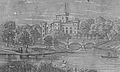
The castle and bridge. Three arches and a lake are illustrated. -
![Eglinton Castle & Bridge. This shows three arches and other differences compared with the surviving bridge.[6] This bridge seems closer to the castle and could be the original bridge which was replaced by the tournament bridge.](//upload.wikimedia.org/wikipedia/commons/thumb/4/48/Eglinton_castle_swan.jpg/120px-Eglinton_castle_swan.jpg)
Eglinton Castle & Bridge. This shows three arches and other differences compared with the surviving bridge.[6] This bridge seems closer to the castle and could be the original bridge which was replaced by the tournament bridge. -

The castle and bridge in 1884. -

The Tournament bridge and castle in 1876. -
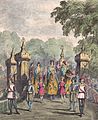
The procession crossing the Tournament Bridge. -
A view of the castle and a wooden footbridge in 1815. -
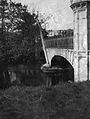
The approach to the Tournament Bridge from the stables in 2007.
_colour.jpg)

![Eglinton Castle & Bridge. This shows three arches and other differences compared with the surviving bridge.[6] This bridge seems closer to the castle and could be the original bridge which was replaced by the tournament bridge.](./wiki.php?slug=File:Eglinton_castle_swan.jpg)


The Tournament Bridge and WWII
The Eglinton Castle Estate was requisitioned during World War 2 and during this occupation the Tournament Bridge partly collapsed, possibly due to alteratioms which had been made earlier by the Eglinton estate, involving supposed strengthening using brickwork. To save the bridge the army encased the cast iron arches in concrete.
Repair work
-
A view showing the partial collapse of the bridge. -

Repair work underway. -
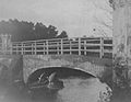
The repaired bridge. Note the simple wooden handrail and the remaining exposed iron arch. -

A view of the whole of the repaired bridge. Note the army personnel and lots of children fishing, etc.


Other Eglinton Castle Estate bridges across the Lugton Water


Originally the river would have been crossed by simple fords, however by the 18th century ornamental pleasure gardens had been formed and these were partly situated in what later became the deer park. No signs of these gardens are now visible, apart from Crop marks on aerial photographs taken around the end of the Second World War. A bridge was necessary to give access and one is indicated on John Ainslie's map dated 1790, crossing the Lugton Water close to the castle itself. A small wooden bridge across the Lugton Water is shown in an illustration from around 1815.

The restored Stables Bridge lies on the Kilwinning Lodge drive and just downstream from it stood a wooden bridge which had high quality stonework on both of the abutments, much of which survive. This bridge gave access to the kitchen walled gardens and glasshouse ranges. The Suspension Bridge built by the army on behalf of the country park lies just below the weir beside the ruined gazebo. Lady Jane's cottage had a wooded pedestrian footbridge of which no sign remains.
-
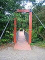
The Suspension Bridge over the Lugton Water. -

Lady Jane's cottage with its footbridge across the Lugton Water. -

The Chapelholm or 'Diamond' bridge. -
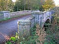
The Stable's Bridge.


The Lugton Water

The Lugton Water was diverted and altered several times, for example in the 1790s its course was altered by the 12th Earl (1740 - 1819)[7] to run behind the Garden Cottage, rather than in front of it. The width was also changed at times, for instance five ponds or lakes were created by large weirs at one stage; the one at the Tournament Bridge is clearly visible in older prints of the 1840s (see illustrations) shown .[8]
The size, shape and position weirs were altered several times, latterly by Clement Wilson of the canning factory. One of the weirs lies directly beneath the restored Tournament Bridge. The one below the site of the old Bowling Green and Robert Burn's garden was 'U' shaped, holding back sufficient water to form a lake with a small island.
The Clement Wilson gardens
In 1948 the Trustees of the late 16th Earl sold most of the remaining parts of the estate to Robert Howie and Sons of Dunlop for £24,000[9][10] and in the 1950s the Wilson family purchased the Tournament Bridge, old offices, castle ruins, and other land from Robert Howie and Sons.
Clement Wilson, the food processing factory owner, established the Clement Wilson Foundation which opened part of the grounds to the public, spending around £400,000 on partially restoring the Tournament Bridge, consolidating the castle ruins, planting trees, landscaping, making paths, creating a rockery and waterfall feature, etc.
2008 restoration

The restoration of the Tournament Bridge involves a faithful and historic renovation of the Tournament Bridge, based on surviving documentary evidence. Historic Scotland requires a ‘faithful restoration where all details are replicated as closely as possible in terms of material, design and construction’. The existing concrete arches are to be removed as is the infill above. The arches will be replaced with the existing refurbished cast iron arch sections and new cast iron fascia sections, which will restore the original width of the structure. The bridge will be given a new timber deck with anti-slip coating.
The current timber parapets will be replaced with cast iron sections to match the original items. All of the cast iron elements are to be fabricated and fitted by an approved foundry to restore the splendour of the original structure.
See also
References
- ^ "Stagecoach West Scotland - A1 Service". Retrieved 2007-11-05.
- ^ Dobie, James (1876). Pont's Cuninghame Pub. John Tweed.
- ^ Ness, J. A. (1969 - 70). Landmarks of Kilwynnyng. Privately produced. P. 29.
- ^ Aitken, Robert (1829). The Parish Atlas of Ayrshire - Cunninghame. Pub. W. Ballantine. Edinburgh.
- ^ Historic gardens
- ^ Leighton, John M. (1850).Strath Clutha or the Beauties of the Clyde. Pub. Joseph Swan Engraver. Glasgow. Facing p. 229.
- ^ Landscape of the Knights. The Eglinton Story. Rub. Irvine Development Corporation. 1992. P. 27.
- ^ Montgomeries of Eglinton. Ayr Division. Strathclyde Department of Education. P. 94.
- ^ Landscape of the Knights. The Eglinton Story. Rub. Irvine Development Corporation. 1992. P. 12.
- ^ Sharp, Cameron (2007). Eglinton Country Park Management Plan for 2007 - 2011. North Ayrshire Council. P. 5.