
Laigh Milton Viaduct: Difference between revisions
Rosser1954 (talk | contribs) |
Rosser1954 (talk | contribs) |
||
| Line 36: | Line 36: | ||
== Construction and operation of the Kilmarnock & Troon Railway == |
== Construction and operation of the Kilmarnock & Troon Railway == |
||
In 1807, William Bentinck, the Marquess of Titchfield commissioned [[William Jessop]] to survey the line.<ref name="Lewin">Lewin, Henry Grote (1925). Early British Railways. A short history of their origin & development: 1801-1844. London: The Locomotive Publishing Co Ltd.</ref> Jessop had already been involved with early railways, notably the Surrey Iron Railway. The contractor was John Simpson. Formerly coal had been taken by road to the harbour at Irvine, some for export to Ireland (8000 tons in 1790). The line was authorised in 1808 and in 1809 the marquess became the 4th [[Duke of Portland]], the largest landowner in [[Ayrshire]]. In 1811 the 10 mile (9 miles and six furlongs)<ref name="Mackintosh4">Mackintosh, Ian M. (1969), ''Old Troon and District.'' Pub. George Outram, Kilmarnock. Map facing P. 48.</ref> long line opened with two tracks of 4ft gauge worked by horses. The 3ft long flanged 'L' section rails, weighing 40 lbs each, were mounted with iron spikes driven into wooden plugs within stone blocks, 9 to 12 inches in thickness and rather more than a foot square at base and surface.<ref name="Robertson">Robertson, William (1905). ''Old Ayrshire Days''. Pub. Stephen & Pollock. Ayr. P. 299 - 300.</ref> 70,000 stone 'sleepers' were required at 6d. each, and a similar number of cast-iron rails, transported from [[Glenbuck]] at an estimated £20,000. The wagons wheels had no flanges. The tramway cost around £4,000 a mile to build.<ref name="Robertson">Robertson, William (1905). ''Old Ayrshire Days''. Pub. Stephen & Pollock. Ayr. P. 299 - 300.</ref> |
In 1807, William Bentinck, the Marquess of Titchfield commissioned [[William Jessop]] to survey the line.<ref name="Lewin">Lewin, Henry Grote (1925). Early British Railways. A short history of their origin & development: 1801-1844. London: The Locomotive Publishing Co Ltd.</ref> Jessop had already been involved with early railways, notably the Surrey Iron Railway. The contractor was John Simpson. Formerly coal had been taken by road to the harbour at Irvine, some for export to Ireland (8000 tons in 1790). The line was authorised in 1808 and in 1809 the marquess became the 4th [[Duke of Portland]], the largest landowner in [[Ayrshire]]. In 1811 the 10 mile (9 miles and six furlongs)<ref name="Mackintosh4">Mackintosh, Ian M. (1969), ''Old Troon and District.'' Pub. George Outram, Kilmarnock. Map facing P. 48.</ref> long line opened with two tracks of 4ft gauge worked by horses, with frequent communications from one road to the other, so as to not only allow carriages to go both directions, but also to allow one carriage to pass another when both are travelling in the same direction.<ref name="Mackintosh4">Mackintosh, Ian M. (1969), ''Old Troon and District.'' Pub. George Outram, Kilmarnock. P. 44.</ref> The 3ft long flanged 'L' section rails, weighing 40 lbs each, were mounted with iron spikes driven into wooden plugs within stone blocks, 9 to 12 inches in thickness and rather more than a foot square at base and surface.<ref name="Robertson">Robertson, William (1905). ''Old Ayrshire Days''. Pub. Stephen & Pollock. Ayr. P. 299 - 300.</ref> 70,000 stone 'sleepers' were required at 6d. each, and a similar number of cast-iron rails, transported from [[Glenbuck]] at an estimated £20,000. The wagons wheels had no flanges. The tramway cost around £4,000 a mile to build.<ref name="Robertson">Robertson, William (1905). ''Old Ayrshire Days''. Pub. Stephen & Pollock. Ayr. P. 299 - 300.</ref> |
||
The gap between the rails was described as the 'horse path', filled with road metal,<ref name="Robertson">Robertson, William (1905). ''Old Ayrshire Days''. Pub. Stephen & Pollock. Ayr. P. 299 - 300.</ref> and that between the two tracks as the 'attendants' path'. During restoration a layer of small broken stone was found at about the former track level, and presumably formed the 'attendants' path'. Three broken plate rails were also found at this level. Ordinary carts could use the route on payment of a toll, much like the [[Haytor Granite Tramway]] and therefore strictly speaking the line was a tramway. Men were employed to sweep the rails clean of ballast kicked up by horses. The line was laid with a gentle 1 in 660 gradient. The horses could pull 160-220 cwts uphill and 200-240 cwts downhill. In 1839 130,500 tons were carried over the railway. There was a passenger service operated with at first just trucks filled with straw for passengers,<ref name="Robertson">Robertson, William (1905). ''Old Ayrshire Days''. Pub. Stephen & Pollock. Ayr. P. 299 - 300.</ref> but later two 'true' carriages, 'Caledonia' and 'The Boat', both built in [[Dundonald]], were purchased, with a through journey costing a shilling. Horses were changed at a stable at Gateside. In 1824, the salt pans on the Troon North Shore were acquired by Mr. Archibald Finnie, Kilmarnock, and he converted the buildings at the Pans into dwelling houses and stables for the men and horses employed on the rail-way (sic).<ref name="Mackintosh">Mackintosh, Ian M. (1969), ''Old Troon and District.'' Pub. George Outram, Kilmarnock. P. 43.</ref. |
The gap between the rails was described as the 'horse path', filled with road metal,<ref name="Robertson">Robertson, William (1905). ''Old Ayrshire Days''. Pub. Stephen & Pollock. Ayr. P. 299 - 300.</ref> and that between the two tracks as the 'attendants' path'. An ambiguous reference states that the distance between the rail roads or courses being the same as the width of each, a horse may travel in the middle space, with a wheel on the inner range of each of the roads.<ref name+"Mackintosh4">Mackintosh, Ian M. (1969), ''Old Troon and District.'' Pub. George Outram, Kilmarnock. During restoration a layer of small broken stone was found at about the former track level, and presumably formed the 'attendants' path'. Three broken plate rails were also found at this level. Ordinary carts could use the route on payment of a toll, much like the [[Haytor Granite Tramway]] and therefore strictly speaking the line was a tramway. Men were employed to sweep the rails clean of ballast kicked up by horses. The line was laid with a gentle 1 in 660 gradient. The horses could pull 160-220 cwts uphill and 200-240 cwts downhill. In 1839 130,500 tons were carried over the railway. There was a passenger service operated with at first just trucks filled with straw for passengers,<ref name="Robertson">Robertson, William (1905). ''Old Ayrshire Days''. Pub. Stephen & Pollock. Ayr. P. 299 - 300.</ref> but later two 'true' carriages, 'Caledonia' and 'The Boat', both built in [[Dundonald]], were purchased, with a through journey costing a shilling. Horses were changed at a stable at Gateside. In 1824, the salt pans on the Troon North Shore were acquired by Mr. Archibald Finnie, Kilmarnock, and he converted the buildings at the Pans into dwelling houses and stables for the men and horses employed on the rail-way (sic).<ref name="Mackintosh">Mackintosh, Ian M. (1969), ''Old Troon and District.'' Pub. George Outram, Kilmarnock. P. 43.</ref. |
||
The Advertiser Times Herald of Troon advertised on June 15, 1812, ''The Caledonia, to carry passengers and goods from Kilmarnock to Troon upon the Iron Railway, will start on Saturday the 27th of June, from Gargieston, until the road is forwarded to Kilmarnock, and every Tuesday, Thursday and Saturday, afterwards at quarter past nine in the morning; and will leave Troon at six o’clock the same evening. Tickets of one shilling will be had of William Paterson, the proprietor – Croft; of Mr Begbie – Angel Inn, Kilmarnock; and of Mr S. Thomson, Troon. Proper attention will be made to passengers and goods'' The journey took something in the region of two hours.<ref name="Advertiser">[http://www.ladyisle.com/times%20past%20index%20of%20articles.htm The Advertiser Times Herald]</ref> |
The Advertiser Times Herald of Troon advertised on June 15, 1812, ''The Caledonia, to carry passengers and goods from Kilmarnock to Troon upon the Iron Railway, will start on Saturday the 27th of June, from Gargieston, until the road is forwarded to Kilmarnock, and every Tuesday, Thursday and Saturday, afterwards at quarter past nine in the morning; and will leave Troon at six o’clock the same evening. Tickets of one shilling will be had of William Paterson, the proprietor – Croft; of Mr Begbie – Angel Inn, Kilmarnock; and of Mr S. Thomson, Troon. Proper attention will be made to passengers and goods'' The journey took something in the region of two hours.<ref name="Advertiser">[http://www.ladyisle.com/times%20past%20index%20of%20articles.htm The Advertiser Times Herald]</ref> |
||
Revision as of 23:06, 25 March 2008
Laigh Milton Viaduct | |
|---|---|
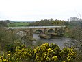
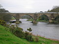
 Laigh Milton Viaduct in East Ayrshire over the River Irvine. | |
| Coordinates | 55°35′56″N 4°34′02″W / 55.5988°N 4.56718°W |
| Carries | Traffic suspended |
| Crosses | River Irvine |
| Locale | Laigh Milton mill at Gatehead in East Ayrshire, Scotland. |
| Official name | Laigh Milton Viaduct |
| Maintained by | East Ayrshire Council |
| Characteristics | |
| Design | William Jessop |
| Total length | 270 ft (82.3m) long by 19ft (5.8m) wide. |
| Longest span | 40ft (12.2m) span with piers 9ft (2.7m) wide. |
| History | |
| Opened | 1812 |
| Location | |
 | |
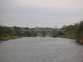
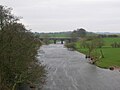
Laigh Milton Viaduct (formerly known as Milton Bridge) is a railway viaduct near Laigh Milton mill at Gatehead in East Ayrshire, Scotland. It lies in the parishes of Kilmaurs and Dundonald, at map reference: NS 3834 3690. The viaduct was closed in 1846 when the railway was realigned.
Laigh Milton viaduct
The stone viaduct was part of the Kilmarnock and Troon Railway. It has four arches with sandstone ashlar facings and rounded cutwaters: these were later extended to form semi-circular buttresses. The railway carried steam locomotives 9 years before the Stockton and Darlington Railway and is believed to be the first passenger steam railway in the world. The viaduct, built in 1811, is the oldest surviving railway viaduct in Scotland,[1] and one of the oldest in the world:[2] therefore having worldwide significance in industrial archaeology.
The Kilmarnock and Troon Railway was built by William Bentinck, Duke of Portland, to convey coal from pits to the west of Kilmarnock to Troon Harbour. It was the first line in Scotland to be authorised by an Act of Parliament and the first in Scotland on which a locomotive was used. The official opening took place on 6 July 1812.[3][4] It was built using cast iron plate rails with an inner flange.[3][4]
There have been three bridges in this general area: furthest north or upstream from Laigh Milton mill the 1811 to 1846 bridge, the approaches to the 1846 to 1865 timber viaduct and furthest south, closer to Gatehead, the present railway viaduct.
Laigh Milton viaduct statistics
The viaduct is about 270 ft (82.3m) long by 19ft (5.8m) wide over all, and it carried the railway about 25ft (7.6m) above the river on four freestone arches of 40ft (12.2m) span with piers 9ft (2.7m) wide. Each arch is of segmental elevation with a rise of one third span and arch rings 2ft (0.61m) deep. No evidence of any former parapets has been found.[5]
Construction details
The piers were probably erected within cofferdams as it is unlikely that any agreement could be reached to lower the water level by temporarily breaching the dam/weir at Laigh Milton mill (NS33NE 51). The west pier is founded on a hard wood platform 5ins (127mm) thick at a depth about 6ft (1.8m) below normal river level, and rests on sand, gravel and weathered bedrock. This timber is saturated but still hard. The poor quality local freestone has eroded more than a foot (0.3m) at and near water level on all the piers, particularly at the west pier, but the foundation courses proved to be of hard stone in good condition. The internal pier hearting comprises thin flat stones bedded and set in lime mortar, and carried up to 5ft (1.5m) above the arch springings. This effective and traditional feature has probably saved the whole structure from collapse.
The arch 'spandrels' are constructed from coursed rubble masonry; gravity-acting retaining walls each run the full length of the viaduct, and vary in width from 1ft (0.3m) at the top to 3ft 6ins (1.1m) at a depth of 9ft (2.7m) by a series of internal steps. The distance between wall-faces is 12ft (3.7m) at depth, the steps being lined up by malleable iron pins, one of which was found in the top of the west arch. The walls simply rest upon the extrados of the undressed archstones without any lateral support apart from any buttressing effect from the bullnoses. The internal drainage comprises a pair of holes through the hearting of each pier down to or below water level. The cavity between the spandrel walls had been filled with stiff clay containing some gravel, probably contributing to the spandrel bulging.
The different masonry elements were not well tied together and some bulging has occurred, notably to the south spandrel wall. Up to several inches of masonry have been lost from much of the external facing, the builders having unwisely used minutely fissured local freestone.[6]
Construction and operation of the Kilmarnock & Troon Railway
In 1807, William Bentinck, the Marquess of Titchfield commissioned William Jessop to survey the line.[3] Jessop had already been involved with early railways, notably the Surrey Iron Railway. The contractor was John Simpson. Formerly coal had been taken by road to the harbour at Irvine, some for export to Ireland (8000 tons in 1790). The line was authorised in 1808 and in 1809 the marquess became the 4th Duke of Portland, the largest landowner in Ayrshire. In 1811 the 10 mile (9 miles and six furlongs)[7] long line opened with two tracks of 4ft gauge worked by horses, with frequent communications from one road to the other, so as to not only allow carriages to go both directions, but also to allow one carriage to pass another when both are travelling in the same direction.[7] The 3ft long flanged 'L' section rails, weighing 40 lbs each, were mounted with iron spikes driven into wooden plugs within stone blocks, 9 to 12 inches in thickness and rather more than a foot square at base and surface.[8] 70,000 stone 'sleepers' were required at 6d. each, and a similar number of cast-iron rails, transported from Glenbuck at an estimated £20,000. The wagons wheels had no flanges. The tramway cost around £4,000 a mile to build.[8]
The gap between the rails was described as the 'horse path', filled with road metal,[8] and that between the two tracks as the 'attendants' path'. An ambiguous reference states that the distance between the rail roads or courses being the same as the width of each, a horse may travel in the middle space, with a wheel on the inner range of each of the roads.Cite error: A <ref> tag is missing the closing </ref> (see the help page). but later two 'true' carriages, 'Caledonia' and 'The Boat', both built in Dundonald, were purchased, with a through journey costing a shilling. Horses were changed at a stable at Gateside. In 1824, the salt pans on the Troon North Shore were acquired by Mr. Archibald Finnie, Kilmarnock, and he converted the buildings at the Pans into dwelling houses and stables for the men and horses employed on the rail-way (sic).Cite error: A <ref> tag is missing the closing </ref> (see the help page).
In 1846 the Glasgow, Paisley, Kilmarnock and Ayr Railway, which from 1843 connected with the line at both ends, leased and rebuilt the line with standard gauge track capable of taking locomotives. It was purchased outright in 1899 by the Glasgow and South Western Railway.
Evidence from Ordnance Survey (OS) and other maps

John Ainslie's map of 1821 and John Thomson's map of 1828 both show the route of the Kilmarnock & Troon railway and the position of the ashlar built Laigh Milton viaduct crossing the River Irvine.[9][10]
The first OS map of 1860 shows the viaduct as part of a track from West Gatehead farm across the Irvine to Cockhill farm and the Craig estate and its other mill, known as Girtrig Mill. A new wooden viaduct (opened in 1846) has replaced the Laigh Milton 'tramway' viaduct and the course of the railway has been altered, the highest point on the bank having been previously chosen (a fluvioglacial terrace), necessitating a pronounced curve in the line at this point. The new bridge required embankments on either side to give sufficient height over the river. On the 'Troon' side the site of the old track has been obliterated by Fairlie Colliery (Pit No.3) and its spoil bings, additionally a mineral line branches off at the Milton Ley, runs at right angles to the viaduct and then across the path of the old track on the Gatehead side and runs up to the Thorntoun and Gatehead collieries.
| Etymology |
| 'Laigh' is the Scots for 'Low'. A 'Toun' or 'Ton' was a farm and its outbuildings, associated here with the Mill as millers often farmed on a small scale.[11] |
The 1898 - 1904 OS shows a mineral line still running to Fairlie Colliery (Pit No.3), but the mineral lines to the Thorntoun and Gatehead collieries have been lifted. The position of the river crossing and a realignment of the route of the railway through Cockhill farm shows that the old wooden bridge has been abandoned and a new bridge built (opened in 1865) slightly further up river.
The 1911 OS marks the trackbed alignment of the first and second bridges, whilst the 1860 mineral line to Thorntoun and Gatehead collieries is now shown as a footpath. Fairlie Colliery (Pit No.3) is still active with several sidings and spoil heaps. No track or lane is as yet shown running to West Gatehead farm.
McNaught's map of 1912 shows the colliery siding and indicates the access over the old viaduct to West Gatehead.[12] It is likely that this access across Laigh Milton viaduct to the colliery allowed some coal to be taken off the site by road and allowed workers to get to and from the colliery.

The 1921 - 28 OS shows the area as Laigh Milton for the first time. The old ashlar viaduct is still clearly shown as part of the farm track to Cockhill farm from West Gatehead. No sign of the realignment of the railway or the old wooden viaduct are indicated and a saw mill is now marked, possibly the cause of the need for the extra definition of the name of the site.
Cockhill and West Gatehead farms were probably part of the Pollok-Morris's Craig Estate in 1921 - 28, but Craig House was later sold to Glasgow Corporation as a 'respite home' for mainly Glaswegian children,[13] and many of the farms sold off. Less access by farm traffic was therefore required across the old viaduct, which was past its centenary by this time, out of railway use, and presumably left to care for itself since abandonment. The result was that the viaduct ceased to be used by wheeled vehicles, allowing vegetation to take over, although the well warn path present prior to the restoration, showed that intrepid pedestrians still risked the crossing.
The 1985 1:25000 OS shows the inter-farm route as still intact, the saw mill isn't marked, and Laigh Milton mill has become a public house. The embankments of the old railway line that ran up to the old wooden viaduct are however shown here.
Restoration

This 4 span viaduct was restored between 1992-96 at a cost of £1.065 million. The viaduct was investigated by radar scanning and apart from the structural repairs many years of invasive vegetation, including trees and shrubs, were removed.
Barr Construction, the main contractors, were awarded the Saltire Society's conservation award for the "skill in restoring a structure on the verge of collapse". There are of course no rails on this part of the line today, however a replica length of the original rails has been laid on the bridge itself. Access to the viaduct is by way of a muddy path alongside the River Irvine from near Laigh Milton Mill, where the old mill weir results in occasional flooding of the path.
Miscellaneous and trivia
The Duke of Portland, hearing of George Stephenson’s work with steam engines at Killingworth in the north east of England, invited him to demonstrate one of his locomotives on the railway. In 1816/7 the locomotive, named The Duke, was set on the rails near Kilmarnock station close to the now demolished Kilmarnock House and was driven by Robert Stephenson. Although the engine proved itself, it was too heavy (5 tons) for the cast-iron track. On the day James and Robert Hood were "the first to fire the first iron horse, who eats coals instead of corn, in Scotland". The old coach-house of Kilmarnock House was turned into a coal store, being only four hundred yards from the tramway.[14] The duke later sold the locomotive on for £70. There is a legend that a locomotive with wooden wheels was in use on the line until 1848.

The Portland Bridge at Kings Mill viaduct of 1817 - 19 is believed to be the oldest railway viaduct as distinct from a single span bridge in England and the fourth oldest railway bridge of any kind in the United kingdom. The three known older ones are in County Durham 1727, Pitnall Tramway Bridge, Derbyshire 1802 and our own Laigh Milton Viaduct of 1811. The engineer of the second and third of these was the famous William Jessop.[3] Josiah Jessop of Kings Mill Viaduct was his son who had assisted his father on many works and later was the engineer of the Cromford and High Peak Railway.
The Dick Institute holds a number of interesting artifacts, such as a map of the original proposed route of the railway, a model of 'The Duke', a painting of passenger and coal trains, details of the track in section, etc.
Gatehead railway station was situated nearby, in the village of that name. It closed on 3 March 1969.
The viaduct has gone by several alternative names, such as Gateside Viaduct, Drybridge Viaduct, West Gatehead Viaduct or even the 'wet bridge',[15] as distinct from the nearby 'Drybridge'.
One story redolent of its era is that of a 'professional class' couple, Mr. & Mrs. Barker from England who committed suicide in Victorian times (24 October 1844) by tying themselves together and jumping from Laigh Milton Viaduct into the Irvine, which has a depth of only around three feet at this point. They were buried in the Kilmaurs-Glencairn churchyard in an unmarked grave. They are known to have spent a few weeks in lodgings and apparently enjoyed the 'sights and sounds' of Ayrshire. It transpired that they had recently become bankrupt and were fearful of the shame and disgrace that poverty would inevitably bring.[12][15]
Gatehead is likely to be named from the Turnpike road and the tool bar. A 'Gatehead Toll Bar' is still marked on the road down to Laigh Milton mill and the Craig house estate on the 1860 OS map.
A hamlet called 'Milton' is marked on the 1821 and 1828 maps,[9][10] but the name is not marked on the 1860 and the more recent OS maps.
The remains of the supports to the wooden viaduct at Laigh Milton can still be seen in the river Irvine when the water is exceptionally low.
The remains of the old Drybridge railway station and the village of the same name are nearby. The name 'Drybridge' comes from the fact that most bridges up until the era of the railways were built over watercourses and were therefore 'wet bridges'. A 'Dry bridge' was such a novelty that the name has survived ever since. This part of the railway is still active as the part of the Glasgow South Western Line (and officially known as the 'Burns Line') running from Kilmarnock to Troon.
The line closed to passengers in the late 1960s but today carries Stranraer to Newcastle and Glasgow to Girvan local passenger trains, although there are no stations open along its course.
2007 Laigh Milton Viaduct gallery
-
Looking towards the old bings of Fairlie Colliery (Pit No.3) -

A side view, looking across to the 'Troon' side. -

Detail of a supporting pier, buttress, ashlar construction, etc. -

A freight train can be seen on the 'new bridge' through the arch. -
The 'new' railway bridge can be seen through the arch on the left -
The river Irvine and the view of the viaduct from near Laigh Milton Mill. -
The plaque describing the section of the replica of the Kilmarnock and Troon Plateway. . -
The operational bridge from the restored viaduct -

The Gatehead side embankment of the 1846 to 1865 wooden bridge -
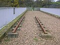
A section of the replica plateway / tramway -
The Restoration Commemorative Plaque -

Detail of a section of the replica of the Kilmarnock and Troon plateway -
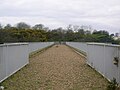
The restored viaduct trackbed -
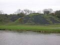
The old Fairlie Colliery's (Pit No.3) bings on the 'Troon' side of the river -

Laigh Milton Mill -

St Maurs-Glencairn kirk where the Barker's are buried.


Other ancient Scottish railway viaducts
The Glasgow, Paisley and Johnstone Canal was purchased in 1869 by the Glasgow and South Western Railway Company. In 1881, an Act of Parliament closed the canal. Much of the route was used to construct the Paisley Canal Line. This line still uses the River Cart Aqueduct (which it crosses at a skewed angle). This makes the former aqueduct the world's oldest railway bridge that is still in active use, having been built sometime between 1807 and 1810.
See also
- Kilmarnock and Troon Railway
- Bridge
- Thorntoun house and estate
- A Researcher's Guide to Local History terminology
References
- ^ "The Official Site of Scotland's National Tourist Board". Retrieved 2007-03-14.
- ^ "The Official Site of Scotland's National Tourist Board". Retrieved 2007-03-14.
- ^ a b c d Lewin, Henry Grote (1925). Early British Railways. A short history of their origin & development: 1801-1844. London: The Locomotive Publishing Co Ltd. Cite error: The named reference "Lewin" was defined multiple times with different content (see the help page).
- ^ a b Awdry, Christopher, (1990). Encyclopaedia of British Railway Companies. London: Guild Publishing.
- ^ "The RCAHMS's Canmore Website". Retrieved 2007-03-15.
- ^ "The RCAHMS's Canmore Website". Retrieved 2007-03-15.
- ^ a b Mackintosh, Ian M. (1969), Old Troon and District. Pub. George Outram, Kilmarnock. Map facing P. 48. Cite error: The named reference "Mackintosh4" was defined multiple times with different content (see the help page).
- ^ a b c Robertson, William (1905). Old Ayrshire Days. Pub. Stephen & Pollock. Ayr. P. 299 - 300.
- ^ a b Ainslie, John (1821). A Map of the Southern Part of Scotland.
- ^ a b Thomson, John (1828). A Map of the Northern Part of Ayrshire.
- ^ Warrack, Alexander (1982)."Chambers Scots Dictionary". Chambers. ISBN 0-550-11801-2.
- ^ a b McNaught, Duncan (1912). Kilmaurs Parish and Burgh. Pub. A.Gardner.
- ^ Strawhorn, John and Boyd, William (1951). The Third Statistical Account of Scotland. Ayrshire. Pub. P. 475
- ^ Smellie, Thomas (1898) Sketches of Old Kilmarnock. Limited Edition of 250 copies. Dunlop & Drennan Printers, Kilmarnock. Section II.
- ^ a b Adamson, Archibald R. (1875). Rambles Round Kilmarnock. Pub. T.Stevenson, Pps. 168–170.
External links
- Ewan Crawford's history of the line
- A photograph and a map of the area
- Some details of the viaduct as a 'Railway' visitor attraction
- An older railway bridge in Wales
- Details of the restoration project
- The Saltire Award
- Maps at the National Library of Scotland
- 1860 OS Maps
- The Portland Bridge at Kings Mill
- The Dick Institute's collection of Kilmarnock & Troon Railway artifacts.