
Eglinton Country Park: Difference between revisions
Rosser1954 (talk | contribs) |
|||
| Line 138: | Line 138: | ||
Within 100 years, Eglinton was deserted. The Tournament marked a turning point, being a severe drain on the family fortune which, together with huge expenditure on the [[Ardrossan]] Harbour and the [[Glasgow, Paisley and Ardrossan Canal]], undermined the resources a family who had been among the great families of Ayrshire.<ref name="Eglinton">[http://www.kilwinning.org/eglintoncastle/default.htm Eglinton Castle history]</ref> |
Within 100 years, Eglinton was deserted. The Tournament marked a turning point, being a severe drain on the family fortune which, together with huge expenditure on the [[Ardrossan]] Harbour and the [[Glasgow, Paisley and Ardrossan Canal]], undermined the resources a family who had been among the great families of Ayrshire.<ref name="Eglinton">[http://www.kilwinning.org/eglintoncastle/default.htm Eglinton Castle history]</ref> |
||
====Tournament re-enactment==== |
|||
1989 was the 150th anniversary of the Eglinton Tournament and the Country Park staff organised a re-enactment which took place on 18 - 20 August that year. |
|||
== Eglinton castle and offices Gallery == |
== Eglinton castle and offices Gallery == |
||
Revision as of 17:00, 26 October 2007
Eglinton Country Park in Scotland covers an area of 400 hectares (988 acres) of North Ayrshire, 175 hectares of which are woodland. Its map reference is NS 3227 4220, situated in the Parish of Kilwinning and the former District of Cunninghame.
The location of Eglinton Park

The park is a one hour drive from Glasgow. Take the M 77 to Kilmarnock and then the A 71 to Irvine, next go north on the A 78 (T) towards Greenock. Leave the A 78 (T) at the Eglinton Junction and follow the signs to Eglinton Country Park.
The park lies just a 30 minutes walk from Kilwinning town centre along the banks of the river Garnock or by the A 737 Irvine - Kilwinning road. Eglinton is a free facility, with no parking charges, no entry fee, and most of the attractions are free (permits are required for fishing and horse riding).
Facilities within the park

Eglinton is a place for having a quiet walk in the woodlands, around the loch or through the Clement Wilson gardens. Having a relaxing day out, a picnic and enjoying the visitor centre, children's play areas, bird watching, etc. Plenty of car parking is available (119 cars), with an overflow or auxiliary 'grass' car park (93 cars). A bus park has spaces for 5 coaches.

The visitors centre is the place to find out what's on at the park. It houses an exhibition on the history of the park, has stocks of all the park leaflets and the gift shop is well stocked with souvenirs and books. The Tournament Cafe supplies snacks and meals.
Full wheelchair access and facilities for disabled visitors are provided. A free mobility scooter and wheelchair loan service operates from the Visitor Centre.
The Racquet hall cottage in the park has been renovated to be let as self-catering accommodation. It sleeps six and is available throughout the year.
A campsite field is available for organised groups such as Scouts, Guides, etc. The visitor facility block has toilets, showers and a dayroom. A charge is made for these facilities.
Eglinton park is served by the North Ayrshire Countryside Ranger Service who offer a programme of guided walks (lasting from 1 to 2 hours) and events from Easter and July - September. The Visitor Centre is open from 10 am to 4.30 pm, 7 days a week from Easter to October. The park is open all year, dawn to dusk.
The park is a contact for pupils and teachers taking part in 'Eco Schools' projects[1] and the rangers are also a contact for 'Scottish Outdoor Access', the code and further details of access to the countryside.[2]
Dogs are welcome as long as they are kept under control. The park is listed as 'Friendly Venue' by the Dog's Trust.
Activities
There is are wet weather shelters with small indoor soft play areas and outdoor play areas. The Racket Hall can also be hired for birthday parties.
Equestrian rides (Bridle Paths)

Within the park there is an extensive bridle path network extending to around 11 km. Of this route a shared paths makes up about 5 km of the route on which riders must give way to walkers and cyclists. The track meanders pleasantly beside fields and woodlands.[3]
Eglinton loch and the Lugton Water
The loch was created through the extraction of materials used in the construction of the A 78 (T) Irvine and Kilwinning bypass. It is marked on old maps as being an area liable to flooding. It is well stocked with coarse fish, fed by the Lugton Water, and a popular spot for anglers and bird watchers. The Lugton Water runs through the park and several weirs were built to raise the water level for ornamental reasons. Several mills were powered by the Lugton Water as shown by names such as 'North and South Millburn', near the hamlet of Benslie.
Eglinton loch and the Lugton Water gallery
-

Eglinton loch from the castle end. -

Eglinton loch from the castle end. -
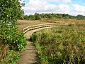
The boardwalk over the loch outflow. -

The Lugton Water near Fergushill and the old Waggonway bridge.


The Irvine New Town Trail
Main article Irvine New Town Trail
The Irvine New Town Trail is a 19 km (12 mile) long cycle path used by many joggers, walkers, dog walkers and cyclists in the area. The route forms a ring as there are no start and end points. The trail passes through Irvine's low green, and goes up to Kilwinning's Woodwynd and Blackland's area. The route passess through the Eglinton Country Park, carries on to Girdle Toll, Bourtreehill, Broomlands, Dreghorn and carries on to the Irvine Riverside and back to the Mall and the Low Green again.[4]
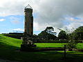
The Belvedere Hill and other pedestrian areas

A plantation is situated on 'Belvedere Hill' (the term 'Belvedere' literally means 'beautiful view') with a classical central 'folly' feature and vistas radiating out from a central hub. This style of woodlands and vistas or rides is a restoration of the layout of the entire area surrounding the castle in the 1750s prior to the remodeling which was completed by 1802. General Roy's map of 1747 - 52 shows that the ornamental woodlands were a series of these radiating vistas of different sizes, sometimes overlapping each other.[5] The old Eglinton Park farm lies to one side of this feature. Many other footpaths are present, a number of which are not shared with cyclists or horses.
Eglinton Gallery 2007
-
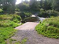
The Lugton Water ford near the castle ruins. -
The sign at the main entrance from the A 78 (T) expressway. -
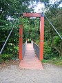
The suspension bridge over the Lugton Water. -
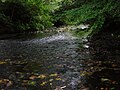
The Lugton Water downstream of the suspension bridge. -
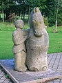
A statue commemorating the Eglinton Tournament near the Visitors centre. -
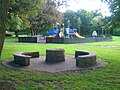
A play area near the visitors centre. -
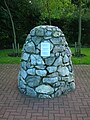
The 9/11 commemorative cairn near the play area. -
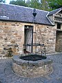
The well in the courtyard outside the Tournament cafe. -
A view of the Tournament cafe. -
A view of the Tournament cafe from the courtyard. -
The old Racket Hall exhibition centre. -
contemporary park seating.


Wildlife
Birds
Recent resident breeding species include: finches, tits, thrush, Pheasant, Grey Partridge, Tawny Owl, Kestrel, Sparrowhawk, Great Spotted Woodpecker, Skylark, Yellowhammer. Resident (but non-breeding): Buzzard. Winter visitors: Fieldfares, Redwings, occasional Waxwings and sightings of Hen Harrier and Kingfisher. Wildfowl include: Goldeneye, Wigeon, Tufted and Mallard ducks with Whooper Swans and geese on passage. Also Woodcock, Snipe, Curlew and Lapwing. Summer migrants: Swifts, Swallows and Martins; Willow, Sedge and Grasshopper Warblers, Blackcap and Chiffchaff. Exotic sightings include cuckoos, White Stork, Black Swan a Flamingo!.[6]
Mammals
Hedgehogs, foxes, moles, pipistrelle bats, mink and roe deer are found in the park and can be seen with luck or by being patient and silent.
Other wildlife
Surveys carried out by the Scottish Wildlife Trust have shown that the park has a good selection of mushrooms, bracket and other species of fungi.
The 'Old Wood' containing the Ice house has a good plant diversity due to the fact that it is long established and relatively undisturbed, unlike the park's plantations which are of a comparatively recent origin. Chapelholms wood shows a similar high biodiversity. Plants such as Dog's Mercury, Tussock grass and Honeysuckle are indicators of old deciduous woodlands.
The History of Eglinton country park
The castle, gardens and estate
Main article Eglinton Castle


The usual spelling is 'Eglinton', however Eglintoun, Eglintoune or Eglintown are encountered in old books and on old maps. The Eglinton Castle ruins, despite their appearance, are of a relatively modern building, the mansion having been completed as recently as 1802, when an older castle was completely demolished. The earliest known castle, even then, the chief seat of the Montgomeries, was burned by the Cunninghames of Glencairn in 1528 and rebuilt afterwards.
The Category B Listed 1802 castle was un-roofed in 1925 and fell into ruins. Commandos used it for exercises during the second world war, and it was also used for naval gunnery practice. In the 1950s further damage was done and the remains were finally demolished to the level they are today (2007) in 1973.[8]
The park was used as a training camp; for vehicle maintenance and as a preparation depot for the Normandy landings during WWII. The remnants of this era are visible in the form of Nissen huts, still in use today and the foundations of other wartime buildings.[9]
The architect had been John Paterson and John Baxter designed the Redburn Gateway & lodges; the iron 'Tournament' bridge was designed by David Hamilton. The landscape gardens, were designed by Tweedie and laid out by Alexander, the 10th Earl, a great agricultural reformer and pioneer. The landscaping works were finished by 1801 and replaced an older style, now represented by the replanted Belvidere Woods.[10]


At their peak The policies and gardens of the estate covered 1346 acres, made up from 624 acres of grassy glades, 650 of plantations, 12 acres of gardens, etc. A high stone wall surrounded the park, which had one six mile long carriage drive and another drive of two miles length inside this wall. Gates and lodges existed in many places, such as at Redburn, Weirstone (Kilwinning), Mid, Girdle, and Stanecastle. Stoddart visited in 1800 on his tour of Scotland and wrote glowingly of the estate as a creation of art.[11]
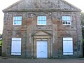
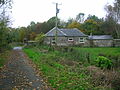
The estate offices, coach house and stables block were built in the 18th-century by John Paterson. They were converted and extended to form a factory by Newforge Canning Factories (Ireland). It later became Wilson's canning factory, but has been out of use for some years and is likely to be redeveloped in the near future.

A bowling green, a little to the west of the Tournament bridge, was said to be the finest in Britain. A deer park surrounded the castle and this is recorded as having contained many fine old trees and an unusual, a 'Deer shelter'.[10]An area called 'Ladyha Park' used to contain a colliery; it lies towards the Kilwinning gate lodge (previously the Weirston gate); on the other side of Ladyha park lies the old fish pond in a field called the 'Bull Park'.
| Etymology |
| The meaning of Ladyha is the 'Haugh' or low lying flat area of the 'Lady'.[12] |
Other features in the grounds of the estate were the 'Formal Gardens' lying between the walled garden and Lady Jane's cottage, commemorative statue, Eglinton house (previously the 'Garden Cottage'), Weirstone house, the Fish Pond, Redburn House (demolished circa 2006), etc. The curtain walls of the Walled Kitchen Garden with Gazebos survive. Loudon in 1824 comments 'the trees of the park are large, of picturesque form and much admired. The kitchen garden is one of the best in the country'. An article in 1833 in the Gardeners' Magazine makes similar remarks and comments on the 'many hundred feet of hot houses'; however, it also notes that the 'grounds are not kept up as they ought to be'.[13]


A strange feature of some considerable size was laid out as a bilaterally symmetrical design near Benslie (previously Benslee) hamlet on the 1750s Roy map. It lies outside the ornamental woodlands and has the 'appearance' of the foundations of a large building, although it was made up of trees.[5] This odd shaped park or 'baroque park' feature has similarities to a 'Celtic' cross shape, a topographical feature mapped by Roy's surveyors. It may be a small hunting park or baroque garden layout similar to that found at the Optagon Park, Alloa Estate, Clackmannanshire; which in turn was after the Dutch taste and modelled on Hampton Court, the favourite home of King William; a dutchman.[14] [15] On the 1938 OS map the Montgreenan side of Benslie wood retains the shape of that part of the baroque garden.
A large number of cottages, such as Higgins, Millburn, Gravel and Hill, and some miners rows existed at one time or other, together with place names such as Higgins, Knadgerhill, Irvine March wood, Meadow plantations and Long Drive; an area close to Eglinton Mains called 'The Circle', Crow and Old Woods, The Hill, etc., etc.
The gardens and gazebo gallery
-

A part of the old walled 'Kitchen Garden'; a Gazebo. -
An old entrance to the walled 'kitchen Gardens'. -

The site of the old 'Formal Gardens' from the walled gardens. -

Surviving walls from the old 'Formal Gardens' beside the Lugton Water.


Listed structures in the park
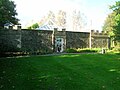
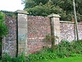
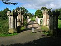
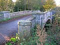
The ruined castle is listed C(S). The Tournament Bridge by David Hamilton which has lost its original Gothic parapet is listed B. The offices and stables built around 1800 are also listed B; the stable court has been converted into a factory, but the office frontage has been preserved. Other listed buildings within the park are the Ice House, C, the Belvedere Gates, C, the Kilwinning Gates, B, the Doocot at the mains Farm, B, the Garden Cottage 1798, B, the walled kitchen gardens and derelict gazebos, C(S), and the Park Bridge, B. There is some ornamentation in the formal garden, but this has been vandalised.[13]
The Eglinton Tournament
Main Article Eglinton Tournament


Eglinton is best known for a lavish, if ill-fated medieval tournament, organised in 1839 by the 13th Earl. It is said that the grand folly of the Eglinton Tournament, sprang directly from the disappointment of the so-called "penny coronation". The Government had decided to scale down the pomp of Victoria's Coronation; one role abolished was that of the Queen's Champion and his ritual challenge in full armour. This role would have fallen to the Knight Marshal of the Royal Household, Sir Charles Lamb of Beaufort, the stepfather of the 13th Earl of Eglinton.[16] The expense and extent of the preparations became news across Scotland, and the railway line was even opened in advance of its official opening to ferry guests to Eglinton. Although high summer, torrential rain washed the proceedings out. The participants, in full medieval dress or armour, gamely attempting to participate in events such as jousting. Amongst the participants was the future Napoleon III of France.[17]
Friends and admirers of the 13th Earl presented him with a magnificent silver commemorative 'trophy' made in a medieval Gothic style which is now kept in Cunninghame House, headquarters of North Ayrshire Council.
Within 100 years, Eglinton was deserted. The Tournament marked a turning point, being a severe drain on the family fortune which, together with huge expenditure on the Ardrossan Harbour and the Glasgow, Paisley and Ardrossan Canal, undermined the resources a family who had been among the great families of Ayrshire.[8]
Tournament re-enactment
1989 was the 150th anniversary of the Eglinton Tournament and the Country Park staff organised a re-enactment which took place on 18 - 20 August that year.
Eglinton castle and offices Gallery
-

The remaining tower from the Lugton Water ford side. -
The tower and foundations of the castle. -

The ruins from the Tournament Bridge side. -

A clear view of the tower and the remaining side wall. -
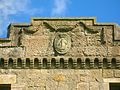
The Montgomery family crest on the castle ruins. -
The approach to the Tournament Bridge over the Lugton Water. -

The Montgomery family crest on the Stables/offices/coach house. -

The Stables, coach house and old estate offices.


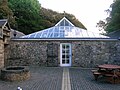
The Carthorse stables, Racquet hall, gas and electricity works
The old carthorse stables, etc. have been converted into offices, a tea room, toilets, etc. A small Doocot is present in the courtyard. The old OS maps show that by 1897 a gas works had been established here to supply the castle and offices, whilst by 1911 this had been replaced by an electricity works; it has been restored and is the present day workshop.
Rackets or Racquets in American English, is an indoor sport played in the United Kingdom, United States, and Canada. The sport is infrequently called "hard rackets," to distinguish it from squash (formerly called "squash rackets"). Eglinton has a 'Racket Hall' which is first shown on the 1860 OS map. It has been restored and converted into an exhibition area.
Lady Jane's cottage ornee


Aiton states that "Near to the gardens, in a remote corner, more than half encircled by the river, a remarkably handsome cottage has been reared, and furnished, under the direction of Lady Jean Montgomery, who has contrived to unite neatness and simplicity, with great taste, in the construction of this enchanting hut. That amiable lady, spends occasionally, some part of her leisure hours, about this delightful cottage: viewing the beauties, and contemplating the operations of nature, in the foliage of leaves, blowing of flowers, and maturation of fruits; with other rational entertainments, which her enlightened mind is capable of enjoying." Such a romantic cottage was called a 'cottage ornee'. Lady Jane Hamilton, the Earl's Aunt built or extended 'Lady Jane's Cottage' which lay beside the Lugton Water. She used this thatched building to teach domestic economy to peasant girls. This may represent a later use of Lady Jean's cottage. Nothing now remains of this cottage, although the 1938 OS map still shows it.[18]
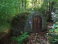
The Ice house


An Ice House lies in the Old Wood fairly near to the doocot on the Draught burn. During the winter ice and snow was taken from the Lugton Water, Draught burn, etc. To keep the ice frozen, doors or openings were usually built facing north and straw or sawdust was added between layers of ice or snow to act as insulation. Treated this way the ice would stay frozen for many months, and would be used to make ice cream, sorbets, chilled drinks, sylabubs and so on consumed during the summer months and the ability to provide these exotic luxuries would raise the owner's social status. The development of compressor driven refrigeration in the latter part of the 19th century rang the death knell for these structures. They were not used for the preservation of foodstuffs.[19]
Ice houses were introduced to the United Kingdom in around 1660 and were commonly brick lined, domed structures, with most of their volume underground. They were often sited under trees and some way from the 'mansion' house.[20] Ice houses varied in design depending on the date and builder, but were mainly conical or rounded at the bottom to hold the melted ice.[21] Rufford Abbey in Sherwood Forest in Nottinghamshire, England had five ice houses! A drain at the bottom took meltwater away and ice houses were often built into earth banks to give extra insulation and to allow for the necessary drainage.[19] As ice houses were mainly the reserve of large manor houses, there are not many good examples left in the UK and those that are found are usually in a state of disrepair.[22]
Doocots, Ice house and miscellaneous gallery
-

The doocot (dovecot) at the site of the old Eglinton Mains farm, now demolished. -
The doocot at the Tournament cafe courtyard. -

The doocot nesting boxes. -

The ice house in the Old Woods from near the Draught burn. -
The ice house entrance. -
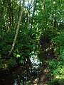
The Draught Burn in the Old Wood near the ice house. -

The Lugton Water near the ford. A source of ice. -

Belvedere loch. -
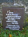
A prayer at the Eglinton loch. -

Chapelholms bridge over the Lugton Water -

Caravans on the site of the old cricket ground. -
The Stable's bridge over the Lugton Water.


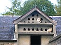
The Doocots
A large ornamental Gothic style Doocot or dovecot (English spelling) is located near the scanty remains of the Eglinton Mains farm, situated on the B 7080 'Long Drive' towards Sourlie Hill interchange. A smaller doocot is built into the stable buildings overlooking the open courtyard. The larger doocot seems to have been actually built as one of the pheasantrys, as it is never marked on OS maps as a doocot and old photographs do not show any internal nesting boxes. It does not appear until 1911 0n OS maps & is located at the edge of a pheasantry enclosure. It would have been used for raising pheasants for field-sports on the old estate.
Curling Ponds
Old OS Maps show that the estate had at least two curling ponds, one near to Weirston House beside the A 737 Kilwinning road and the other in between the Stanecastle and Girdle gates on the old Lochlibo road. A third also existed to the north-west of the castle according to Historic Scotland.
Curling can be a dangerous sport, for Paterson[23] reports that in 1812 Captain Robert Montgomerie of Craighouse, Deputy-Lieutenant of the County of Ayr, died from a contusion of his foot acquired from a curling stone whilst playing at Eglintoun castle!
Cricket ground and pavilion
From 1911 the OS maps show a cricket ground and a substantial pavilion, the latter being parallel to the Lugton Water. One of the Earls employed a cricket professional to provide tuition and he lived in the 'Mid Gates' lodge (just off the main A 78 (T) entrance), which still survives. Neither the cricket ground nor the pavilion still exist, but part of the cricket ground area forms the site for caravaners, etc.
The Cadgers' Racecourse


During each August, Irvine's Marymass Festival takes place as it has done for several centuries. Part of the celebrations are horse racing held on the Cadgers racecourse (a cadger was a person who transported goods on horseback in the days before carts were introduced[7]) on the 'Towns Moor' which was part of the Eglinton estate. The course is clearly shown on a number of old maps, such as the 1775 map by Captain Armstrong, where it is called the 'Race Ground'.[24] Later the Montgomeries purchased the Bogside area and built a new racecourse at which the Scottish Grand National used to be held.
The Gate and gatehouse 2007 gallery
-

The Stanecastle gatehouse -

The old Girdle gate at Girdle Toll. The old gatehouse has been demolished. -

The gates on the Kilwinning road. -

The Weirstone or Kilwinning gatehouse. -
Millburn Lodge and gate; a post 1858 building. -

The restored Belvedere gates near the Visitors Centre. -

Chapelholms gate.


The Feudal lords of Eglinton
The Eglintouns
Eglin, Lord of Eglintoun[25][26] is the first of the family recorded, living during the reign of King Malcolm Canmore who is better known for his father being King Duncan, murdered by Macbeth of Shakespeare fame. He may have been one of the Saxon barons who accompanied Malcolm (who died in 1093) on his successful return to Scotland. The family continued to live at Eglinton until Elizabeth de Eglintoun, the heir, married Sir John de Montgomery of Eaglesham. When Hugh, her father, died soon after 1378 the Montgomery family inherited the lands and hereafter Eglinton's history is bound up with that family.[26]
The Earls of Eglinton and the Clan Montgomery
Main article Earl of Eglinton


The Montgomerie family were involved in many historical events, however they are best known for the feud between themselves and the Cunninghames, Earls of Glencairn, living in and around Stewarton and Kilmaurs. In 1488 the Clan Montgomery burned down the Clan Cunningham's Kerelaw Castle. These two clans had a long feud, partly based on the rights of feudal superiority in old Cunninghame. In 1507 the 3rd Lord was made the 1st Earl of Eglington. During the 16th century the long running feud continued between the Clan Montgomery and the Clan Cunningham. Eglinton Castle was burned down by the Cunninghams and then the Montgomery chief, the 4th Earl of Eglinton was ambushed and murdered by the Cunninghams at the Annick Water ford in Stewarton. The government of King James VI of Scotland eventually managed to get the rival chiefs to shake hands. [28][29]
The present earl is Archibald George Montgomerie, 18th Earl of Eglinton, and 6th Earl of Winton (b. 1939). The heir-Apparent is his son, Hugh Archibald William Montgomerie, Lord Montgomerie (b. 1966). Skelmorlie Castle, near Largs, is the seat of the earl, who is also chief of Clan Montgomery.
Archaeology
Prehistoric sites and finds
A small cordened cinerary urn or beaker was found with several other urns in a tumulus very near to Eglinton Castle; it is now in the National Museum of Antiquities of Scotland. A search for the tumulus in the 1960s found that no traces remained.[30][31] A greenstone axe-hammer was found at Eglinton between the stables and the offices by a Mr. John Palmer in the 19th-century. It is about 8 inches long and perforated near the blunt end. At Pytebog near Eglinton Kennels a stone axe was found in the 1890s.[32] Near 'The Circle' close to old Eglinton Mains farm are the remains of a short cist and aerial surveys show that the Belvidere Hill had a circular enclosure and ditch around its summit. Mesolithic flints and scrapers were found near North Millburn and in Chapelholm woods.[33]

Lawthorn mount
A large and well preserved prehistoric cairn or barrow is present at Lawthorn. Its name is suggestive of a court hill or justice hill, which is indeed the oral tradition. It is 21 paces in diameter at the base, 14 feet in diameter at the top and 9 feet 8 inches high; largely composed of boulders and one large boulder of graywacke stone, 7 feet long, is partially buried on the top edge facing south. An unofficial dig in the 20th-century revealed no finds.[35] See the 'gallery' for a photograph.
Pre-reformation Chapels

Two chapels existed before the reformation, one in the vicinity of Chapelholm woods and South Fergushill farm, the other at Stanecastle gate. The foundations of the chapel were found here by Mr W Gray when digging drains. Judging from the foundations, the building must have been of considerable extent. Local tradition (J Fisher, Sevenacres) supports the findings, makes it more than probable that such a building once existed here. A chapel near Bourtreehill is mentioned by some sources. The 1858 OS map marks the site of a nearby cemetery and an intriguing subterranean passage or vault four feet below the surface; nothing is visible at the site today. A small village once existed here and one source has it that Stanecastle was once part of a nunnery[33] before it became the home of the Francis family; eventually passing to the Montgomerys.
The Stables, coach house and offices

The 1828 map marks this building as 'offices', however it clearly served the function of coach house and stables for coach horses as well. More stables were built in the 1890s for the farm carthorses.
Some of the dressed stone blocks from which the old stables and offices are constructed have masons marks cut into them. This suggests that they may have been taken from the ruins of Kilwinning Abbey in the 18th-century when one of the Earls had the stables built. The design of the Montgomery family crest above the entrance is identical to that on the castle ruins. It is likely that the same architect built both. [10] Kerelaw Castle near Stevenson contained many carved stone coats of arms taken from the old abbey, which was clearly seen as being a convenient source of dressed or ornately carved stone for many a 'new' building in 'old' Cunninghame.
Industrial archaeology


An unusually complex network of mineral railway lines ran through the outer parts of the park in the 19th and 20th centuries, the trackbed now being used as cycle paths in many places. A rare waggon-way bridge still survives near South Fergushill farm on the B 785 Fergushill Road (see photograph). A very complex set of collieries, coal pits and fire-clay works are evident from records such as old maps. Very little remains (above ground at least!) of the buildings and railway lines, but odd depressions in the ground, old embankments and abandoned bridges all bear witness to what was at one time a very active coalfield with associated businesses and infrastructure. A tunnel still survives which once carried a narrow gauge railway line unobtrusively to the Ladyha colliery.[36]

In the Chapelholms wood the 1938 map marks a hydraulic ram and cistern in a bend of the Lugton Water close to one of the old Fergushill collieries. Hydraulic rams harnesses the flow or current force of water to pump a portion of the water being used to power the pump to a point higher than where the water originally started. Rams were often used in remote locations, since it requires no outside source of power other than the kinetic energy of falling water.
Scottish Wildlife Trust reserves
Three areas within the old boundaries of the Eglinton estate have become nature reserves, first developed by the old Irvine Development Corporation, but now owned and managed by the Scottish Wildlife Trust with free access to the public at all times. They are within easy reach of the park. Sourlie woods are situated on the cycle route and the A736 Glasgow road. It shows unmistakable signs of the areas intensive and complex industrial past in the shape of remains of old railway embankments from the London, Midland and Scottish Railway's Perceton branch to Perceton colliery, soil heaps and other signs of coal workings.
| Etymology |
| The meaning of Corsehillmuir is 'Cross' with hill and 'Muir' meaning moorland. All the more ironic when it is recalled that witches and other criminals were burned at the stake here.[12][37] |
Lawthorn woods (locally pronounced 'L'thorn' ) is a remnant of the Lawthorn plantation, which together with the 'Longwalk' and 'Stanecastle' plantations formed a much larger wood that once ran in an unbroken swathe down as far as Stanecastle and the old Stanecastle gate lodges. Lawthorn wood has easy access with a raised boardwalk running through it as a circular path. The other 'half' of the wood has long been reverted to pasture as old maps clearly show.[38]
Corsehillmuir plantation is another woodland reserve in an area which was mainly open pasture and moorland prior to the 19th-century. It is situated off the B 785 between Mid Moncur and Bannoch farms. The historian John Smith records that this was the site of the ecclesiastical burning of witches and other criminals from the barony.[35] It might have been the site of the old churchyard of Segdoune, the name of Kilwinning prior to the establishment of the abbey.[37] The summits of the three low hills within the reserve are each surrounded by a circular ditch and dike, called 'Roundels'; the true purpose of which is unknown, but the exclusion of cattle is the most likely explanation.
Sourlie, Lawthorn and Coursehillmuir gallery
-
The woodland nature reserve at Lawthorn. -
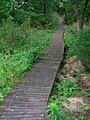
The boardwalk in the nature reserve at Lawthorn. -

The nature reserve at Sourlie. -

One of the Corsehillmuir 'roundels', showing the ditch & bank. -

The Corsehillmuir footpath. -
The Corsehillmuir reserve information board. -
Cairnmount Hill, a Folly near the Sourlie nature reserve. -

Lawthorn mount; a Justice hill and originally a barrow or cairn.


The decline and the rebirth of Eglinton
By 1938 the OS map shows a municipal cemetery at Knadgerhill (opened in 1926) and Ayrshire Central Hospital near the Redburn gate in the Meadow Plantation. In 1948 the Trustees of the late 16th Earl sold the remaining parts of the estate to Robert Howie and Sons of Dunlop.[39]Later a large factory was built in the Crow Wood area (this became Volvo Trucks) and the A 78 (T) with its interchanges and access roads cut through the southern section of the estate (mainly the deer park and the Irvine March wood). Numerous housing schemes were to follow at Girdle Tool, Stanecastle, Knadgerhill, etc., however the establishment of Eglinton Country Park by the old Irvine Development Corporation (IDC) and North Ayrshire Council saved much of the estate for the benefit of all the people of Ayshire and beyond. Eglinton was designated as the 34th of 36 Country Parks in Scotland in 1986.[40]
The Wilson family purchased the old offices, castle ruins, and other land from Robert Howie and Sons. Clement Wilson, the food processing factory owner, established the Clement Wilson Foundation which opened part of the grounds to the public, spending around £400,000 on consolidating the castle ruins, planting trees, landscaping, creating paths, restoring the Tournament Bridge, etc., etc.
Benslie

This hamlet, previously Benslee or Benslee sqaure (1860), is situated next to the wood which once formed the 'Baroque garden.' Part of the outline survives on the Benslie fauld farm side. The name 'fauld' may hold a clue at this is Scots for an area manured by sheep, cattle or possibly deer.[12] Fergushill church in Benslie was built to serve Montgreenan, Doura and Benslie. It was consecrated on Sunday, 3 November 1879 and the first minister was then Rev. William McAlpine.[41] It got its name from the Fergushill Mission which was based at Fergushill school. The old school house is still in existence at the junction of the road to Seven Acres Mill.[42] The manse is now a private house and stands at the entrance to the old Montgreenan railway station drive.
South Fergushill church in Benslie was built to serve Fergushill, Doura and Benslie. It was consecrated on Sunday, 3 November 1879 and the first minister was then Rev. William McAlpine.[41]
Miscellany

The commercial park near Irvine, situated in what was called the 'Crow Wood', has been named 'Tournament Park' and a 'castle' folly has been constructed on the nearby roundabout, commemorating the event. One of the main entrances to the castle, the Redburn gates, ran through this commercial park, however nothing now is left of the old ornamental gates and lodges that existed here, with just a portion of sandstone walling existing at the side of a layby. It is not known what happened to this sundial, but it may survive at another site.
Redburn House, a dower house of the estate, used to be situated opposite the Redburn gates. It had fine gardens with a summer house and a sundial; most likely the characteristic Scottish sundial type, although its present whereabouts are unknown.
The Redburn burn runs through the Eglinton estate from near Stanecastle and is named after the very high red iron salt content. It runs through the nearby 'Garnock Floods' Scottish Wildlife Trust nature reserve before flowing into the Garnock.
The Earls of Eglinton were keen hunters and the Eglinton Kennels (previously called Laigh Moncur) are situated off the B 785 Kilwinning to Benslie road.
Beside the Irvine New Town trail at the Old Wood is a large piece of machinery that appears to be of a military nature. This is actually a 'grubber' or 'rooter' which Robert Howie & Sons brought in to remove many of the old estate trees and create new pasture land. It was restored recently as part of a Countryside Ranger led project.
Of the old farms that are shown on the park guide, only Corsehillhead is still operating.[43]
A boat house was present in 1828 beside the Garnock, just below the old Redburn House. The same map shows an area called 'Game Keppers' near Corsehill, presumably the abode of the estate Game keepers.[44]
John Thomson's map of 1820 marks the 'Gallow Muir' near Bogside. The name suggests that this was the site of the Gallows, probably linked with the medieval right of 'Pit & gallows', held by the Lord of the Barony. This right was removed in 1747. In 1813, 31 unemployed men were given work levelling the Gallows Knowe at the muir prior to the construction of the new Academy. The wooden base of the gallows and several other associated finds were made.[45]
The A 78 (T) and B7080 are partially built on the old estate's 'Long Drive' carraigeway to Stanecastle. The road from the Eglinton interchange to the Hill roundabout and onwards towards Dreghorn has been named 'Long Drive'.
A piggery was built at the park before it was purchased by the local authority. A few of its buildings survive.
£100,000 was spent by the Montgomerys on creating Ardrossan's harbour and they intended to make it the principal port for Glasgow. Construction of the Glasgow, Paisley and Johnstone Canal began in 1807 and the first boat, the passenger boat, The Countess of Eglinton, was launched in 1810; completion to Glasgow's Port Eglinton from Paisley was achieved in 1811, but the section to Ardrossan was never built.[46]
See also
- Clyde Muirshiel Regional Park
- Annick Lodge
- Bourtreehill house
- Girdle Toll
- Barony and Castle of Giffen A Montgomery possession.
- River Irvine
References
- ^ Eco School contacts
- ^ Outdoor Access Code and contacts.
- ^ Bridle paths within Eglinton Country Park.
- ^ The Eglinton to Irvine via Dreghorn cycleroute
- ^ a b General Roy's Maps. Cite error: The named reference "Roy" was defined multiple times with different content (see the help page).
- ^ Bird Records
- ^ a b Dobie, James (1876). Pont's Cuninghame Pub. John Tweed.
- ^ a b Eglinton Castle history
- ^ Sharp, Cameron (2007). Eglinton Country Park Management Plan for 2007 - 2011. North Ayrshire Council. P. 32.
- ^ a b c Millar, A.H. (1885). The Castles and Mansions of Ayrshire. Reprinted. Grimsay Press. ISBN 1-84530-019-x P. 74.
- ^ Stoddart, John (1801). Remarks on Local Scenery and Manners in Scotland. 1799 -1800. Pub. William Miller, London. P. 313.
- ^ a b c Warrack, Alexander Edit. Chambers Scots Dictionary. Pub. W. & R. Chambers, Edinburgh.
- ^ a b Historic gardens
- ^ Swan, Adam (1987). Clackmannan and the Ochils. Pub. Scottish Academic press. ISBN 07073-0513-6 19.
- ^ Ayrshire History Website
- ^ 'The Queen's Champion'.
- ^ Paterson, James (1871) Autobiographical Reminiscences. Pub. Maurice Ogle & Co. Glasgow. P. 163 - 184
- ^ Millar, A. H. (1885). The Castles & Mansions of Ayrshire. Reprinted The Grimsay Press. ISBN 1-84530-019-x. P. 74
- ^ a b [http://www.1066.net/summerfields/ice-house.htm Ive Houses} Cite error: The named reference "Ice House" was defined multiple times with different content (see the help page).
- ^ Situation of ice Houses
- ^ Ice Houses
- ^ A Victorian Ice House uncovered
- ^ Paterson, James (1863-66). History of the Counties of Ayr and Wigton. V. - III - Cunninghame. J. Stillie. Edinburgh. P.87.
- ^ Armstrong and Son. Engraved by S.Pyle (1775). A New Map of Ayr Shire comprehending Kyle, Cunningham and Carrick.
- ^ Paterson, James (1866) History of the Countie sof Ayrs and Wigton. Vol.III - Cuninghame. Pub. James Stillie, Edinburgh. P. 490.
- ^ a b Robertson, William (1908). Ayrshire. Its History & Historic Families. Vol.2. Reprint by Grimsay Press. ISBN 1-84530-026-2 p.49. Cite error: The named reference "Robertson" was defined multiple times with different content (see the help page).
- ^ Smith, John (1895). Prehistoric Man in Ayrshire. Pub. Elliot Stock. P. 59.
- ^ The Feud between the Montgomeries and the Cunnighames of Glecairn.
- ^ Robertson, William (1889). Historical Tales and Legends of Ayrshire. Pub. Hamilton, Adams & Co., Glasgow. P. 15 & 16.
- ^ Archaeol Scot (1890). 'List of donations presented to the Society of Antiquities of Scotland'. Archaeol Scot, 5, 3, 1861-80, Appendix, P. 57.
- ^ Macdonald, J (1878a)'Notices of ancient urns found in the cairns and barrows of Ayrshire'. Archaeol Hist Collect Ayr Wigton, 1, 1878, P. 51
- ^ Smith, John (1895). Prehistoric Man in Ayrshire. Pub. Elliot Stock. P. 60.
- ^ a b RCAHMS Canmore site
- ^ Billings, Robert W. (1901). The Baronial and Ecclesiastical Antiquities of Scotland. Pub. Oliver & Boyd, Edinborough. Vol. III. Plate 41.
- ^ a b Smith, John (1895). Prehistoric Man in Ayrshire. Pub. Elliot Stock. Cite error: The named reference "Smith61" was defined multiple times with different content (see the help page).
- ^ Sharp, Cameron (2007). Eglinton Country Park Management Plan for 2007 - 2011. North Ayrshire Council. P. 36.
- ^ a b Ker, Rev. William Lee (1900) Kilwinnning. Pub. A.W.Cross, Kilwinning. P. 161.
- ^ Old Maps held by the National Library of Scotland
- ^ Sharp, Cameron (2007). Eglinton Country Park Management Plan for 2007 - 2011. North Ayrshire Council. P. 5.
- ^ Sharp, Cameron (2007). Eglinton Country Park Management Plan for 2007 - 2011. North Ayrshire Council. P. 6.
- ^ a b Ker, Rev. William Lee (1900) Kilwinnning. Pub. A.W.Cross, Kilwinning. P. 153.
- ^ Ker, Rev. William Lee (1900) Kilwinnning. Pub. A.W.Cross, Kilwinning. P. 151.
- ^ Sharp, Cameron (2007). Eglinton Country Park Management Plan for 2007 - 2011. North Ayrshire Council. P. 18.
- ^ Thomson, John (1828). A Map of the Northern Part of Ayrshire.
- ^ Historic guide to Irvine
- ^ Robertson, C.J.A., (1983). The Origins of the Scottish Railway System: 1722 - 1844. Edinburgh: John Donald. ISBN 0-85976-088-X.
Bibliography
- Adam, W (1812) Vitruvius Scoticus: being a collection of plans, elevations, and sections of public buildings, noblemen's and gentlemen's houses in Scotland: principally from the designs of the late William Adam Esq., architect, Edinburgh, plate 123.
- Anon (1916) The House of Montgomerie and its Chiefs, (Eglinton Castle). Scot Country Life, 3, 10, 1916, October, P. 437 - 441.
- Bryden, R. (1908). Ayrshire castles.
- Fenwick, H. (1976). Scotland's castles, London, P. 302.
- Macintosh, John (1894). Ayrshire Nights' Entertainments. Pub. Dunlop & Drennan. P. 316 - 325.
- Millar, A. H. (1885a) The castles and mansions of Ayrshire illustrated in seventy views with historical and descriptive accounts, Edinburgh.
- Shaw, J. E. (1953). Ayrshire 1745-1950: a social and industrial history of the county, Edinburgh.
External links
- RCAHMS Canmore archaeology site
- Satellite Imagery of the area
- Horse riding at Eglinton
- The castle in Groomes Gazetteer for Scotland
- General Roy's Military Survey of Scotland 1747 - 52
- Old maps of Scotland from the National Library
- Old Ordnance Survey Maps
- Scotways - for the preservation, defence, restoration and acquisition of public rights of access
- Sustrans National Cycle Network