
Barony and Castle of Giffen: Difference between revisions
Rosser1954 (talk | contribs) mNo edit summary |
Rosser1954 (talk | contribs) |
||
| Line 55: | Line 55: | ||
Upon the death in October 1709 of George Allardyce, Master of the Scottish Mint, John was appointed to the post. He went on to become the MP for Ayr at the 1710 General election, and became one of the gentlemen of the bedchamber to [[George II]], when Prince of Wales. John Montgomerie seems to have been totally uninterested in the affairs of the mint and his personal finances were in some disarray. He at one point proposed an exchange of his post at the mint for a commission in the Foot Guards and ended up with both. In June 1717 he assigned his salary to a third party, having withdrawn from any active involvement. In 1727 he was appointed as Governor of [[New York]], where he remained until his death on 1 July 1731.<ref name="Murray">Murray, Athol L. (1999). The Scottish Mint after the recoinage, 1709 - 1836. PSAS, 129, P.861 - 886.</ref> He had been forced to sell his estates and it was Sir John Anstruther who purchased Giffen under the burden of liferent as Francis was still living. |
Upon the death in October 1709 of George Allardyce, Master of the Scottish Mint, John was appointed to the post. He went on to become the MP for Ayr at the 1710 General election, and became one of the gentlemen of the bedchamber to [[George II]], when Prince of Wales. John Montgomerie seems to have been totally uninterested in the affairs of the mint and his personal finances were in some disarray. He at one point proposed an exchange of his post at the mint for a commission in the Foot Guards and ended up with both. In June 1717 he assigned his salary to a third party, having withdrawn from any active involvement. In 1727 he was appointed as Governor of [[New York]], where he remained until his death on 1 July 1731.<ref name="Murray">Murray, Athol L. (1999). The Scottish Mint after the recoinage, 1709 - 1836. PSAS, 129, P.861 - 886.</ref> He had been forced to sell his estates and it was Sir John Anstruther who purchased Giffen under the burden of liferent as Francis was still living. |
||
Robert Montgomerie of Bogston was a factor and baron bailie of Giffen barony court in the late 17th-century.<ref name="Paterson81">Paterson, James (1863-66). History of the Counties of Ayr and Wigton. V. - III - Cunninghame. J. Stillie. Edinburgh. P.81.</ref> is at odds with Dobie's (1876) account.<ref |
|||
====The Darien Affair==== |
====The Darien Affair==== |
||
Revision as of 12:04, 27 July 2007
Introduction
The Barony of Giffen and its associated 15th-century castle were in the parish of Beith in the former District of Cunninghame, now North Ayrshire. The site may be spelled Giffen or Giffin and lay within the Lordship of Giffin, which included the baronies of Trearne, Hessilhead, Broadstone, Roughwood and Ramshead. The barony of Giffen was comprised of a number of properties, such as Greenhills, Thirdpart, Drumbuie, Nettlehirst.
Giffen has a recorded history that covers many of familiar aspects of a feudal barony, including a 'Moot' or 'Justice Hill' here represented by 'Greenhills', as well as a thirled mill and a 'gathering place' known as the 'Borestone'. Other features such as the old chapel and the holy well add to the expected features, most of which do not however survive!
The History of Giffen Castle
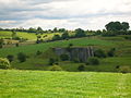
The tower castle of Giffen lay near to the existing Mains of Giffen on the summit of a whinstone trap ridge at (NS 37727 50718). Macgibbon and Ross suggest that Giffen Castle was built in the 15th century, although the 13th-century land grant to Walter de Mulcaster and the prior existence of a chapel, suggest that a defensive structure of some sort was present at that date. At the time of Pont's survey (J Dobie 1876), it was a tower 30ft square, 40ft high, with walls 6ft thick. It fell into disrepair soon after 1726 and finally collapsed in 1838. It has also be known as Griffen on some old maps.

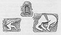
The castle was acquired by Sir John Anstruther in the early 18th-century and he allowed it to fall into ruin, together with Giffin farm. The Sundial originally in the Giffen castle garden was sold and was moved eventually to Crummock house, also in Ayrshire. This sundial had its horizontal plane divided by volutes, between which a lion's head alternates with a rose; it was made in 1719 and repaired in 1810. Farm houses were built from the stone of the front wall of the castle, which was entirely removed. Above the entrance door their had been a carving of a man shooting with a crossbow at what has been called a wild boar. It is not unlikely that this commemorates a feat of bold hunting by a member of the family of Giffen. A similar carving at Linton parish church commemorates just such a feat, for which William the Lion knighted him and bestowed upon him the lands and barony of Linton.[1]
On 12th April, 1838, during the silence of the night, the old castle fell, leaving little more than aheap of stones. Mains of Giffin farm had been feued by Anstruther to Robert Craig in 1726. John King of 'Giffin Miln' built his house using stone from the castle and this is how the old carvings came to be incorporated into the walls of this building. Thomas Craig, grandson of Robert, passed on the feu to Thomas White in 1816, during whose possession the castle met its final fall, inspiring the the following indignant poem by James Wilson:
|
In August 1956 the OS reported that the remains of Giffen Castle now consist of three fragments of rubble masonry, the largest portion measuring 4.0m long by 2.0m thick and 1.9m high. The remainder of the castle was demolished about 1920 when the adjoining quarry was dug.

In June 1983 the OS visited the site again and stated that there are no remains of the castle in situ. The three fragments of masonry are in fact large tumbled blocks, and together with a mass of loose shaped stone, also from the castle, form a garden rockery. A stone lintel above the doorway of the adjacent Mains house is inscribed RC MC 1758. This appears contemporaneous to the single story house and of doubtful association with the castle.
Mr. Robert King, the farmer of the lands near Giffen castle reported in the 1890s that when digging drains to the north-east of the castle he came across a large number of bones which tradition says were there as a result of a battle fought by the lord of the castle, his retainers and an attacking party. The bones were in a hollow to the west of the castle, and between it and the high ground on which the castle and village of Giffen stood.[3]
Giffen village
General Roy's survey of 1747 - 55 spells the name as 'Giffin' and indicates a cluster of buildings; a village, to the south of castle.
The Chapels and the Chapel Well
The chapel and well lay near to Giffen castle according to John Smith, however another chapel and well dedicated to St.Bridget existed at Trearne on a low hill, with an associated burial ground. The ruins at Trearne were destroyed by quarrying in comparatively recent times. In the 12th-century, the Laird, William de Nenham granted had granted land to the monastery of Dryburgh and a chapel was built to the south-east of the castle, next to the well which is still marked on the 2001 OS map, known locally as the chapel well.[4] William's son Richard granted more land at this site, however his brother Alexander inherited and wished for his chapel to be held by the monastery of Kilwinning and not Dryburgh. To achieve this end he gave land for a site at Trearne, next to St.Bridget's chapel which had previously been granted to the Monks of Dryburgh.
The Barony chapel at Trearne was for the souls of Richard de Morville, William de Morville, Roland of Galloway, Elen de Morville and of their heirs, as well as that of Walter de Mulcaster, his ancestors and his successors.[4] The chapel at Giffen was likely to have been for the same overlords or superiors, but also for Alexander de Nenham, his ancestors and his successors.
This situation of excambied or exchanged lands has led to some confusion in that three chapels existed at one time within the Lordship of Giffen, not two as is sometimes stated.[5] The other chapel was in Beith.
Giffen castle Gallery 2007
-
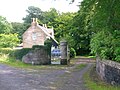
The Giffen mill complex and Giffen brae; the road to Mains of Giffen and Burnhouse. -

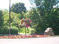
The woodland denotes the site of old Giffen castle. See the 1860s print above as a comparison. -
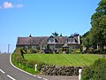
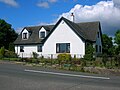
Mains of Giffen, partly built with stones from Giffen castle. -

Mains of Giffen and the road to Barrmill from Burnhouse.


The Lairds of Giffen
In the 13th-century Walter de Mulcaster obtained the lands of Giffen from the De Morvilles in the reign of William the Lion; and in turn gifted them to his sub-vassal, Alexander de Nenham. Alexander gifted to the monastery of Dryburgh fifty acres which had a chapel and a well to St.Bridget, previously founded by the monastery of Kilwinning, the ruins of which were still to be seen, together with a burial ground. Note that Paterson's version (1866)[2] is at odds with Dobie's (1876) account.[4] The De Morvilles were supporters of John Baliol and upon the succession of Robert the Bruce to the crown of Scotland they were dispossessed and Giffen reverted to the crown. Sir Hugh de Eglintoun married Egidia, sister of Robert II and was given the Lordship in 1370. Giffen then remained in the Montgomerie family for several centuries. The barony seems to have been more or less consistently passed to the Master or heir of Eglintoun for many years, however in 1505 the first Earl took the barony into his personal care. After this the barony passed back and forth amongst the family when cadet lines failed to produce issue.
Sir Robert Montgomerie, son of Sir John de Montgomerie of Ardrossan, Baron of Parliament, had been the first Montgomerie of Giffen in around 1400. Various sons inherited and in 1560 Patrick Montgomerie was a member of the Great Parliament which established the Protestant faith in Scotland. He was later banished for a time because of his reformation principles and was succeeded by a dughter who married John Montgomerie of Scotstoun and inherited part of the Giffen lands. Being without further issue the Eglintoun Montgomerie's, in the person of the Hon. Robert, brother to Hugh, the murdered 4th Earl, inherited the barony, producing an heiress, Margaret. He is said incidently to have "hourably revenged" his brother's death. Margaret married twice, but had no issue and the barony again reverted to the Eglintoun branch. 'Grey Steel' was the appelation given to Sir Henry Montgomerie of Giffen who inherited, however he had no issue and once agin the barony reverted.
The seventh Earl's second son, the Right Hon. Francis inherited and lived an eventful life. He was one of the Lords of the Privy Council, and a Commissioner of the Treasury, in the reign of William III and Queen Anne. He was appointed in 1706 as one of the Commissioners for Scotland for the Treaty of Union. Francis acquired the estate of Hessilhead and built an addition to the old tower as well as slating the roof, making it one of the finest properties in the district on behalf of his eldest son, Liuet.-Colonel John Montgomerie of Giffen, whilst continuing to live at Giffen for the remainder of his life.
Upon the death in October 1709 of George Allardyce, Master of the Scottish Mint, John was appointed to the post. He went on to become the MP for Ayr at the 1710 General election, and became one of the gentlemen of the bedchamber to George II, when Prince of Wales. John Montgomerie seems to have been totally uninterested in the affairs of the mint and his personal finances were in some disarray. He at one point proposed an exchange of his post at the mint for a commission in the Foot Guards and ended up with both. In June 1717 he assigned his salary to a third party, having withdrawn from any active involvement. In 1727 he was appointed as Governor of New York, where he remained until his death on 1 July 1731.[6] He had been forced to sell his estates and it was Sir John Anstruther who purchased Giffen under the burden of liferent as Francis was still living.
Robert Montgomerie of Bogston was a factor and baron bailie of Giffen barony court in the late 17th-century.[7] is at odds with Dobie's (1876) account.Cite error: The <ref> tag has too many names (see the help page).
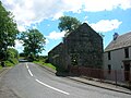
Giffen Mill
The old feudal mill, also known as Barmill, Barrmill or Baroil is at Map reference: NS 3699 5133. The remains visible today are early 19th century. It was a three-storey, four-bay rubble building on a rectangular plan, now gutted and used as a store until recently. The substantial miller's house is still occupied and is in very good condition. On General Roy's survey of 1747 - 55 Giffin Mill is present with a cluster of buildings nearby. The mill pond and lade are clearly marked on the 1858 OS map and a sand pit is marked nearby. By 1923 - 4 the OS map no longer marks the mill or its lade and mill pond.
Giffen mill Gallery 2007
-
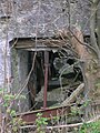
The remains of the waterwheel inside the mill extension. -

Inside the mill looking towards Greenhill. -

The main mill machinery. -
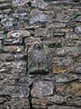
The 'Eagle' in the lower gable wall -
Carvings at the mill from the old castle -
The 'Eagle' from Giffen castle, now in the lower gable wall of Giffen mill. -

Giffen mill and Miller's house.


Greenhills hamlet
This small settlement is shown on General Roy's survey of 1747 - 55, under the name of 'Greenhill' in the singular and has two buildings indicated where the old school is situated. A smithy stood at the crossroads on the Borestone farm side of the hamlet. This hamlet is named after the artificial mound, a Moot, Law or Justice hill that once stood here.
The Moot or Justice hill
This mound was the site where proclamations of the Giffen Castle Baronial Court's judgements were made. For serious crimes the men were hung here and women were drowned a pit which would have been nearby. This situation, known as the feudal Barony right of 'pit and gallows' existed at many other sites, such as at Beith, Kilmarnock, Aiket, Ardrossan, and Dalry. Often the mounds were wooded and a Dule Tree may have been used as the gallows. Brehons or Judges administered justice from 'Court Hills', especially in the highlands. Auchenmade had a Law hill mound nearby, possibly destroyed by the railway. The 'Green hill' stood near to Greenhill farm.[8] No sign of the Moot hill seems to survive, however a bridge near to Greenhill is marked as 'Tappethillock', meaning a flat-topped hillock, which may refer to it.
Borestone farm and The Bore stane
In 1876 Dobie recorded that the Bore Stone or Stane was a large sandstone about 11 1/2 inches in diameter, situated on the farm of Borestone to which it gave name (Name Book 1856). It had a circular opening in which it is said the flagstaff of the lordship or barony used to be erected when vassals from the neighbourhood were summoned to battle; at this position it would have been visible to all parts of the barony and beyond.[8][3] but it is more likely to be a natural cavity caused by weathering. The farmer, Mr Craig was not sure in 1895 if the stone was genuine, however we will never know as the Bore Stone was broken up about 1950 according to Mrs Greyside of Borestone Farm. It was at map reference: NS 3742 5054.
Thirdpart
This was an 8s. land, part of the Giffen Barony and in 1663 fued to John Wilson by the Earl of Eglintoun. It remained in that family until at least 1876. James Wilson of Thirdpart was a notable local eccentric who wrote and published poems on such topics as the Trearne Cattle Shows, the fall of Giffin Castle and the Misfortunes of a clocking-hen. James died in 1838.[9] A small mansion had been present here, occupied in the 1570s by John Montgomerie of Scotstoun, a near relative of the Laird of Hessilhead.[10]
Barrmill
This village had a population of 600 in 1951 and the threadmaking industry had just ceased, although the workers still live din company houses and were transported daily to the threadmaking factory at Kilbirnie. The limestone works was still active, but it too closed in 1972. The whinstone quarries of Messrs. King & Co. employed a considerable number of men, but even then the quarries were almost worked out.[11] Giffen coal pit (No 1) lay close to Bankhead Moss as shown on the 1897 OS map, closing not long afterwards as the following OS maps cease showing it.
Giffen, Beith, or Nettlehirst limeworks
Giffen Limeworks dated from the mid to late 19th century and later. They were Probably the last traditional limeworks to work in Scotland, closing in 1972. A substantial amount remains, with a bank of two single-draw rubble kilns, reinforced with buttresses and with old rails, and heightened in brick. Covered conveyors linked the segmental-arched draw holes with a wood-framed, corrugated-iron crushing and bagging mill. The works were at map reference: NS 3645 5073.
The Local railways

At NS 356 5111) is Giffenmill Viaduct, opened 1903 by the Lanarkshire and Ayrshire Railway. A 7-span viaduct, with semi-circular concrete arches, now disused. It is also known as the Barr Mill or Dusk Water viaduct. The local station opened on 3 September 1888 and was known as Kilbirnie Junction, however it was renamed Giffen on 1 October 1889.[12] Giffen had three platforms, a small station building, and at one point at least seven members of staff. The platforms still survive (2007), but the line running through the station serving DMC Beith is no longer in use (2007).
Barrmill railway station served the village of Barrmill and was originally part of the Glasgow, Barrhead and Kilmarnock Joint Railway branch from Lugton to Beith. It was the only intermediate station on the route, opening on 26 June 1873, and closing permanently to passengers on 5 November 1962. Freight services continued on the line until 1964. On the 1897 OS map a tramway is shown running down to Barrmill station from quarries at Dockra.
Giffen, Greenhills, and Barrmill Gallery 2007
-
The remains of the old limekiln near Nettlehirst farm. -
The old school at Greenhills. -

The Old Giffen station. -

The Old Station Inn in Barrmill. -
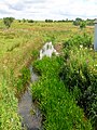
The Dusk Water which powered Giffen Mill. -
The Giffin House entrance near Auchenmade. -
Barmill's millennium garden. -

Barmill's mainstreet with the railway bridge, looking towards Greenhills.


Burnhouse
This village or hamlet lies on the Uplawmoor road to Glasgow. A Crossroads Inn is marked on John Thomson's map of 1828 and in 1858 it had two inns at the crossroads, the Burnhouse Inn and the Waggoners Inn; no longer shown on the 1911 OS. What is now the Burnhouse Manor hotel was present as a private house as marked on the 1858 OS map and as the Manor House in 1911.
Additional evidence from maps
The 1858 OS map shows the spelling as 'Giffen' and indicates the presence of a small whinstone quarry at the bottom of the brae that runs towards Burnhouse. This quarry expanded over the years and eventually destroyed the site of the castle on the Giffen craigs. The castle ruins are clearly marked in 1858, but not afterwards.
Miscellany
A small hoard of 16th century coins was found on 7th March 1958 by A Wilson and A M Raeside when ploughing 250 yards southwest of Mains of Giffon. The coins had been placed in the bronze container of a small nest of weights, 1 1/2 inches in diameter. This box, and 12 of the 19 coins were retained by the National Museum of Antiquities of Scotland (NMAS). All Scottish, they dated between 1558 (a billon "nonsunt" of Mary) and 1574 (a half-merk of James VI). The coins are mostly half and quarter-merks of James VI; they were probably hidden in the later 1570s. [13]
Drumbuie was part of the barony of Giffen and was fued out to various local millers and farmers in the 17th-century.[14] Records show that a William Giffen was appointed councillor in 1710 in Corsehill. Trearne house was used by a small boarding school called Gresham House until it was demolished in 1954.
See Also
References
- ^ a b Dobie, James (1876). Pont's Cunninghame topographized 1604-1608 with continuations and illustrative notices (1876). Pub. John Tweed. P.164. Cite error: The named reference "Dobie164" was defined multiple times with different content (see the help page).
- ^ a b Paterson, James (1863-66). History of the Counties of Ayr and Wigton. V. - III - Cunninghame. J. Stillie. Edinburgh. P.98.
- ^ a b Smith, John (1895). Prehistoric Man in Ayrshire. Pub. Elliot Stock. P. 83.
- ^ a b c Dobie, James (1876). Pont's Cunninghame topographized 1604-1608 with continuations and illustrative notices (1876). Pub. John Tweed. P.377.
- ^ Paterson, James (1863-66). History of the Counties of Ayr and Wigton. V. - III - Cunninghame. J. Stillie. Edinburgh. P.65.
- ^ Murray, Athol L. (1999). The Scottish Mint after the recoinage, 1709 - 1836. PSAS, 129, P.861 - 886.
- ^ Paterson, James (1863-66). History of the Counties of Ayr and Wigton. V. - III - Cunninghame. J. Stillie. Edinburgh. P.81.
- ^ a b Dobie, James (1876). Pont's Cunninghame topographized 1604-1608 with continuations and illustrative notices (1876). Pub. John Tweed. P.163.
- ^ Dobie, James (1876). Pont's Cunninghame topographized 1604-1608 with continuations and illustrative notices (1876). Pub. John Tweed. P. 376.
- ^ Dobie, James (1876). Pont's Cunninghame topographized 1604-1608 with continuations and illustrative notices (1876). Pub. John Tweed. P. 196.
- ^ Strawhorn, John and Boyd, William (1951). The Third Statistical Account of Scotland. Ayrshire. Pub. P. 407.
- ^ Butt, R. V. J. (1995). The Directory of Railway Stations. Patrick Stephens Ltd, Sparkford.
- ^ R B K Stevenson, R.B.K.(1960); Proc Soc Antiq Scot 1961.
- ^ Dobie, James (1876). Pont's Cunninghame topographized 1604-1608 with continuations and illustrative notices (1876). Pub. John Tweed. P.125.