
Western Ghats: Difference between revisions
→References: +ref |
→Rivers: +ref |
||
| Line 113: | Line 113: | ||
==Rivers== |
==Rivers== |
||
[[Image:Mighty Jog.jpg|thumb|The [[Jog Falls]] in Karnataka is one of the most spectacular waterfalls in India.]] |
[[Image:Mighty Jog.jpg|thumb|The [[Jog Falls]] in Karnataka is one of the most spectacular waterfalls in India.]] |
||
The Western Ghats form one of the three [[Drainage basin|watershed]] of India, feeding the perennial rivers of peninsular India. Important rivers include the [[Godavari River|Godavari]], [[Krishna River|Krishna]], and [[Kaveri River|Kaveri]]. Rivers that flow to the west drain out into the [[Arabian Sea]]. These rivers are fast-moving, owing to the short distance travelled and steeper gradient. Important rivers include the [[Mandovi]], [[Zuari River|Zuari]], and [[Periyar River|Periyar]]. Many of these rivers feed the backwaters of Kerala and Maharashtra. Rivers that flow eastwards of the Ghats drain into the [[Bay of Bengal]]. These are comparatively slower moving and eventually merge into larger rivers such as the Kaveri and Krishna. Smaller rivers include the [[Chittar River]], [[Bhima River]], [[Malaprabha River]], [[Manimuthar River]], [[Kabini River]], [[Kallayi River]], [[Kundali River]], [[Pachaiyar River]], [[Pennar River]], and the [[Tambaraparani River]]. |
The Western Ghats form one of the three [[Drainage basin|watershed]] of India, feeding the perennial rivers of peninsular India. It forms the catchment area for a complex of river systems that drain almost 40% of India.<ref>{{cite web |
||
| url=http://www.westernghatsforum.org/abstract_12_05.pdf |
|||
| author=V.S. Vijayan |
|||
| title=''Research needs for the Western Ghats'' |
|||
|publisher=Ashoka Trust for Research in Ecology and the Environment (ATREE) |
|||
|accessdate=2007-06-21 |
|||
}}</ref> Important rivers include the [[Godavari River|Godavari]], [[Krishna River|Krishna]], and [[Kaveri River|Kaveri]]. Rivers that flow to the west drain out into the [[Arabian Sea]]. These rivers are fast-moving, owing to the short distance travelled and steeper gradient. Important rivers include the [[Mandovi]], [[Zuari River|Zuari]], and [[Periyar River|Periyar]]. Many of these rivers feed the backwaters of Kerala and Maharashtra. Rivers that flow eastwards of the Ghats drain into the [[Bay of Bengal]]. These are comparatively slower moving and eventually merge into larger rivers such as the Kaveri and Krishna. Smaller rivers include the [[Chittar River]], [[Bhima River]], [[Malaprabha River]], [[Manimuthar River]], [[Kabini River]], [[Kallayi River]], [[Kundali River]], [[Pachaiyar River]], [[Pennar River]], and the [[Tambaraparani River]]. |
|||
Fast running rivers and steep slopes have provided various state governments set large hydro-electric projects. There are about major 50 dams along the length of the Western Ghats with the earliest project up in 1900 near [[Khopoli]] in Maharashtra.<ref>{{cite web |
Fast running rivers and steep slopes have provided various state governments set large hydro-electric projects. There are about major 50 dams along the length of the Western Ghats with the earliest project up in 1900 near [[Khopoli]] in Maharashtra. <ref>{{cite web |
||
| url=http://www.rainwaterharvesting.org/resources/statistics/stat233.htm |
| url=http://www.rainwaterharvesting.org/resources/statistics/stat233.htm |
||
| title=Indian Dams by River and State |
| title=Indian Dams by River and State |
||
Revision as of 02:27, 23 June 2007
Template:Geobox Mountain Range
The Western Ghats(सह्याद्री - Sahyadri mountains) are a mountain range to the west of peninsular India. They run along the western edge of the Deccan Plateau, and separate the plateau from a narrow coastal plain along the Arabian Sea. The range starts south of the Tapti River near the border of Gujarat and Maharashtra, and runs approximately 1600 km through the states of Maharashtra, Goa, Karnataka, Tamil Nadu and Kerala ending at Cape Comorin or Kanyakumari, the southern tip of the Indian peninsula. The average elevation is around 1,200 meters[1]. The area is one of the world’s eight "Hottest biodiversity hotspots" and has over 5000 species of flowering plants, 139 mammal species, 508 bird species and 179 amphibian species. At least 325 globally threatened species occur in the Western Ghats.[2]
Mountains
The Western Ghats of Maharashtra spread from the Satpura Range to the north, and continue south past Goa to Karnataka. The major hill range of the sector is Sayadhri range, which is home to the hill stations of Mahabaleshwar and Panchgani. The Biligirirangans southeast of Mysore in Karnataka, meet the Shevaroys (Servarayan range) and Tirumala range farther east, linking the Western Ghats to the Eastern Ghats. This range is also known as the Sahyadri mountains in Maharashtra and Karnataka, Nilagiri malai in Tamilnadu, and Sahya Parvatam in Kerala.
Smaller ranges, including the Cardamom Hills and the Nilgiri Hills with Doddabetta being the highest peak at 2,623 metres (8,606 ft), are in northwestern Tamil Nadu. In the southern part of the range in the Anaimalai Hills, in western Tamil Nadu and Kerala, Ana Mudi 2,695 metres (8,842 ft) is the highest peak in India, south of the Himalayas. Chembra Peak 2,100 metres (6,890 ft), Banasura Peak 2,073 metres (6,801 ft), Vellarimala 2,200 metres (7,218 ft) and Agasthya mala 1,868 metres (6,129 ft) are also in Kerala. The major gaps in the range are the Goa gap, between the Maharashtra and Karnataka sections, and the Palghat Gap on the Tamil Nadu/Kerala border between the Nilgiri Hills and the Anaimalai Hills.
The northern portion of the narrow coastal plain between the Western Ghats and the Arabian Sea is known as the Konkan Coast or simply Konkan, and the southern portion is called Malabar region or the Malabar Coast. The foothill region east of the Ghats in Maharashtra is known as Desh, while the eastern foothills of central Karnataka state is known as the Malnad region. The largest city within the mountains is the city of Pune, in the Desh region on the eastern edge of the range.
The mountains intercept the rain-bearing westerly monsoon winds, and are consequently an area of high rainfall, particularly on their western side. The dense forests also contribute to the precipitation of the area by acting as a substrate for condensation of moist rising orographic winds from the sea, and releasing much of the moisture back into the air via transpiration, allowing it to later condense and fall again as rain.
Geology
The Western Ghats are not true mountains, but are the faulted edge of the Deccan plateau.[1] They are believed to have been formed during the break-up of the super continent of Gondwana some 150 million years (mya) ago. Geo-physicists Barren and Harrison from the University of Miami advocate the theory that the west coast of India came into being somewhere around 100 to 80 mya after it broke away from Madagascar. After the break-up, the western coast of India would have appeared as an abrupt cliff some 1,000 metres in height.[3]
Soon after its detachment, the peninsular region of the Indian plate drifted over the Réunion hotspot, a volcanic hotspot in the earth's lithosphere near the present day location of Réunion (21°06′S 55°31′E / 21.100°S 55.517°E). A huge eruption here some 65 mya is thought to have laid down the Deccan Traps, a vast bed of basalt lava that covers parts of central India. These volcanic upthrusts led to the formation of the northern third of the Western Ghats. Since these uplifts are dome-shaped in nature, the underlying rock is ancient, dating back 200 mya, and can be observed in some parts such as the Nilgiris.[4]
Basalt is the predominant rock found in the hills reaching a depth of Template:Unit length. Other rock types found are charnockites, granite gneiss, khondalites, leptynites, metamorphic gneisses with detached occurrences of crystalline limestone, iron ore, dolerites and anorthosites. Residual laterite and bauxite ores are also found in the southern hills.[5]
Climate

Climate in the Western Ghats varies with altitudinal gradation and distance from the equator. The climate is humid and tropical in the lower reaches tempered by the proximity to the sea. Elevations of Template:Unit length and above in the north and Template:Unit length and above in the south have a more temperate climate. Average annual temperature here are around 15 °C (60 °F). In some parts frost is common, and temperatures touch the freezing point during the winter months. Mean temperature range from 20 °C (68 °F) in the south to 24 °C (75 °F) in the north. It has also been observed that the coldest periods coincide with the wettest.[4]
During the monsoon season between June and September, the unbroken Western Ghats chain acts as a barrier to the moisture laden clouds. The heavy, eastward-moving rain-bearing clouds are forced to rise and in the process deposit most of their rain on the windward side. Rainfall in this region averages 3,000–4,000 mm (120–160 in) with localised extremes touching 9,000 mm (350 in). The eastern region of the Western Ghats which lie in the rain shadow, receive far less rainfall averaging about 1,000 mm (40 in) bringing the average rainfall figure to 2,500 mm (150 in). Data from rainfall figures reveal that there is no relationship between the total amount of rain received and the spread of the area. Areas to the north in Maharashtra receive the heaviest rainfall, but are followed by long dry spells, while regions closer to the equator receive less annual rainfall, with rain spells lasting almost the entire year.[4]
Rivers

The Western Ghats form one of the three watershed of India, feeding the perennial rivers of peninsular India. It forms the catchment area for a complex of river systems that drain almost 40% of India.[6] Important rivers include the Godavari, Krishna, and Kaveri. Rivers that flow to the west drain out into the Arabian Sea. These rivers are fast-moving, owing to the short distance travelled and steeper gradient. Important rivers include the Mandovi, Zuari, and Periyar. Many of these rivers feed the backwaters of Kerala and Maharashtra. Rivers that flow eastwards of the Ghats drain into the Bay of Bengal. These are comparatively slower moving and eventually merge into larger rivers such as the Kaveri and Krishna. Smaller rivers include the Chittar River, Bhima River, Malaprabha River, Manimuthar River, Kabini River, Kallayi River, Kundali River, Pachaiyar River, Pennar River, and the Tambaraparani River.
Fast running rivers and steep slopes have provided various state governments set large hydro-electric projects. There are about major 50 dams along the length of the Western Ghats with the earliest project up in 1900 near Khopoli in Maharashtra. [7] Most notable of these projects are the Koyna Dam in Maharashtra, the Parambikulam Dam in Kerala, and the Linganmakki Dam in Karnataka. The reservoir behind the Koyna Dam, the Shivajisagar Lake, is one of the largest reservoirs in India with a length of Template:Unit length and depth of Template:Unit length.[8]
During the monsoon season, numerous streams fed by incessant rain drain off the mountain sides leading to numerous and often spectacular waterfalls. Among the most well known is the Jog Falls, Kunchikal Falls, Sivasamudram Falls, and Lushington Falls. The Jog Falls is the highest natural waterfall in South Asia.
Biome Protection
Historically the Western Ghats were well-covered in dense forests that provided wild foods and natural habitats for native tribal people. Its inaccessibility made it difficult for people from the plains to cultivate the land and build settlements. After the arrival of the British in the area, large swathes of territory were cleared for agricultural plantations and timber.
The area is ecologically sensitive to development and was declared an ecological hotspot in 1988 through the efforts of ecologist Norman Myers. Though this area covers barely five percent of India's land, 27% of all species of higher plants in India (4,000 of 15,000 species) are found here. Almost 1,800 of these are endemic to the region. The range is home to at least 84 amphibian species, 16 bird species, seven mammals, and 1,600 flowering plants which are not found elsewhere in the world.
The Government of India established many protected areas including 2 biosphere reserves, 13 National parks to restrict human access, several wildlife sanctuaries to protect specific endangered species and many Reserve Forests, which are all managed by the forest departments of their respective state to preserve some of the ecoregions still undeveloped. Many National Parks were initially Wildlife Sanctuaries. These hill ranges serve as important wildlife corridors, allowing seasonal migration for species like elephants.
In 2006, India applied to the UNESCO MAB for this region to be listed as a protected World Heritage Site. [9]. This will be composed of 7 adjoining areas:
- Agasthyamalai Sub-Cluster (with Five Site Elements) including: The Agasthyamalai Biosphere Reserve 900 km², includes Kalakkad Mundanthurai Tiger Reserve 806 km², in Tamilnadu and Neyyar[10], Peppara[11] and Shendurney[12] Wildlife Sanctuaries and their adjoining areas of Achencoil [13], Thenmala, Konni[14], Punalur, Thiruvananthapuram Divisions and Agasthyavanam Special Division in Kerala[15].
- Periyar Sub-Cluster (with Six Site Elements) including: Periyar National Park and nature reserve 777 km², in Kerala, Ranni, Konni and Achankovil Forest Divisions. On the eastern side, lying largely in a rain-shadow area with mostly drier forests, lie the Srivilliputtur Wildlife Sanctuary and reserved forests of the Tirunelveli Forest Division.
- Anamalai Sub-Cluster (with Seven Site Elements) including: Chinnar Wildlife Sanctuary, Indira Gandhi National Park, Grass Hills National Park and Karian Shola National Park are located within the larger Indira Gandhi Wildlife Sanctuary 958 km², Mudumalai National Park 321 km², and Palani Hills National Park 736.87 km² (PRO) in Tamilnadu and Parambikulam Wildlife Sanctuary 285 km² in Kerala.
- Nilgiri Sub-Cluster (with Six Site Elements) including: The Nilgiri Biosphere Reserve with Eravikulam National Park 90 km², Karimpuzha National Park 230 km² (PRO), Silent Valley National Park 89.52 km² and Wayanad Wildlife Sanctuary 344 km² in Kerala, Bandipur National Park 874 km², Mukurthi National Park 78.46 km², New Amarambalam Reserved Forest in Tamilnadu. This sub-cluster constitutes a largely secure forest complex of over 6,000 km², which is one of the most globally significant conservation areas for highly threatened species such as the Asian elephant, tiger and gaur, besides dozens of endangered species in other taxa.
- Talacauvery Sub-Cluster (with Six Site Elements) including:Brahmagiri Wildlife Sanctuary 181.29 km², Rajiv Gandhi (Nagarhole National Park) 321 km², Pushpagiri Wildlife Sanctuary 92.65 km², Talacauvery Wildlife Sanctuary (105.01 km²) in karnataka and Aralam Reserved Forest in Kerala.
- Kudremukh Sub-Cluster (with Five Site Elements) including: Kudremukh National Park 600.32 km², Someshwara Wildlife Sanctuary and surrounding Reserved Forests of Someshwara, Agumbe and Balahalli in karnataka.
- Sahyadri Sub-Cluster (with Four Site Elements) including: Anshi National Park 340 km², Chandoli National Park 317.67 km², Koyna Wildlife Sanctuary and Radhanagri Wildlife Sanctuary in Maharashtra.
Flora

The hills are home to four tropical and subtropical moist broadleaf forests – the South Western Ghats moist deciduous forests, South Western Ghats montane rain forests, North Western Ghats moist deciduous forests, and North Western Ghats montane rain forests. The northern portion of the range is generally drier than the southern portion, and at lower elevations makes up the North Western Ghats moist deciduous forests ecoregion, with mostly deciduous forests made up predominantly of teak.
Above 1,000 meters elevation are the cooler and wetter North Western Ghats montane rain forests, whose evergreen forests are characterized by trees of family Lauraceae. The evergreen Wayanad forests of Kerala mark the transition zone between the northern and southern ecoregions of the Western Ghats. The southern ecoregions are generally wetter and more species-rich. At lower elevations are the South Western Ghats moist deciduous forests, with Cullenia the characteristic tree genus, accompanied by teak, dipterocarps, and other trees. The moist forests transition to the drier South Deccan Plateau dry deciduous forests, which lie in its rain shadow to the east.
Above 1,000 meters are the South Western Ghats montane rain forests, also cooler and wetter than the surrounding lowland forests, and dominated by evergreen trees, although some montane grasslands and stunted forests can be found at the highest elevations. The South Western Ghats montane rain forests are the most species-rich ecoregion in peninsular India; eighty percent of the flowering plant species of the entire Western Ghats range are found in this ecoregion.
Fauna
The area is home to at least 139 mammal species, 508 bird species, 334 butterfly species and 179 amphibian species including at least 325 globally threatened species. The Western Ghats are home to many endemic species, especially in the amphibian and reptilian fauna. The snake family Uropeltidae is almost entirely restricted to and diversified in this region of the world. The frog Nasikabatrachus sahyadrensis was discovered in 2003 as being a living fossil. This species of frog is most closely related to species found in the Seychelles. Some Western Ghats streams are home to several brilliantly coloured ornamental fishes like Puntius denisonii, Osteobrama bakeri, Horabagrus brachysoma and freshwater puffer fish Tetraodon travancoricus, Carinotetraodon imitator apart from marine forms like Chelonodon patoca (Buchanan-Hamilton,1822)[16]; mahseers like Tor malabaricus [17]
One of the endemic species of the Western Ghats is the Lion-tailed Macaque. There are only 4000 of this species remaining in the Western Ghats. The lion-tailed macaques are characterized by certain typical behaviour patterns such as arboreal living, selectively feeding on a large variety of fruit trees, large inter-individual spaces while foraging, and time budgets with high proportion of time devoted to exploration and feeding.
The Lion-tailed Macaque primarily eats indigenous fruits, leaves, buds, insects and small vertebrates. In areas of massive selective logging, with disruption of forest canopy and reduction of native trees, lion-tailed macaques can adapt through behavioural modifications and broadening their food choices to include fruits, seeds, shoots, pith, flower, cone, mesocarp, and other parts of many non-native and pioneer plants.[18]
About sixty percent of the Western Ghats are located in the state of Karnataka.[19] Most of Karnataka's five hundred species of birds [14] are from the Western Ghats region.[20] The evergreen forests of Nagarahole, deciduous forests of Bandipur National Park and Nugu in Karnataka and adjoining regions of Wayanad and Mudumalai National Park in the states of Kerala and Tamil Nadu form the single largest protected area in the Western Ghats system comprising some 5500 km². This is also called the Nilgiri Biosphere Reserve.[21] This is home to the largest population of the Asian Elephant and forms an important "Project Elephant" and "Project Tiger" reserve. Karnataka's ghats are home to over six thousand elephants (as of 2004). The largest population of tigers outside the Sundarbans ecosystem is also believed to be found in these unbroken forests bordering Karnataka, Tamil Nadu and Kerala. The largest numbers and herds of Gaur are found here with the Bandipur National Park and Nagarahole together holding over five thousand Gaur.[22]
The Biligirirangan Hills lies at the confluence of the western and Eastern Ghats. Karnataka's Ghat areas holds about twenty five percent of all Asian elephants and ten percent of India's tiger population.[23]
North of this region is the Kudremukh national park in the central region of Karnataka's Western Ghats. Kudremukh National Park has one of the most beautiful landscapes in the Western Ghats, encompassing evergreen, semi-evergreen and grassland shola habitat characteristic of high altitude Western Ghats regions. This park protects a viable population of Lion tailed macacque.
To the west are the forests of Kodagu which hold sizeable populations of the endangered Nilgiri Langur and have numerous bird species. Brahmagiri and Pushpagiri wildlife sanctuaries are important elephant habitat. Talakaveri wildlife sanctuary is a critical watershed and the source of the river Kaveri. This region has dense evergreen and semi-evergreen vegetation, with shola-grassland in areas of higher elevation. The steep terrain of the area has resulted in scenic waterfalls along its many mountain streams.
Bhadra Wildlife Sanctuary and project tiger reserve in Chikmagalur has large populations of Indian muntjac. This is an excellent birding region. Since it is located at the northern end of the Malabar ranges and the southern tip of the Sahyadri ranges, bird species from both ranges can be seen here.
Sharavathi and Someshvara Wildlife sanctuaries in Shimoga district are the source of the Tungabhadra River system. Bannerghatta National park and reserve forest of Annekal close to Bangalore are an important elephant corridor connecting the forests of Tamil Nadu with those of Karnataka. Dandeli and Anshi national parks in Uttara Kannada district are home to the Black Panther and normal variety of leopards and significant populations of Great Indian Hornbill. These large birds congregate even near human habitation inside the park regularly. Bhimgad in Belgaum district is a proposed wildlife sanctuary and is home to the endemic Wroughton's freetailed bat (Otomops wroughtoni), the Krishnapur caves close by are one of only three places in the country where the little-known Theobald's tomb bat (Taphozous theobaldi) is found. The rare Megaderma spasma bats are found in the Talevadi caves.[24] Karnataka's ghats are also the home to several scenic waterfalls including the Jog falls and are listed as one among the 1001 natural wonders of the world.[25] With the exception of four wildlife sanctuaries, all the remaining 22 national parks and wildlife sanctuaries of Karnataka are located in the Western Ghats, either at the evergreen higher elevations or deciduous lower elevation regions.
The Western Ghats in Kerala is home to tea and coffee plantations, reserved forests, and dense tropical jungles. Elephant, Gaur, Sambar, and Wild Boars dwell in the forests. Sloth Bear, Leopard and tiger are also found. The Western Ghats in Kerala is home to numerous serene hill stations like Munnar, Ponmudi, Waynad etc. The Silent Valley National Park in Kerala is among the last tracts of virgin tropical evergreen forest in India.[26]
-
 Lightmatter lion-tailed macaque
 -
 Tiger at Bhadra Wildlife Sanctuary
 -
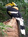 Great Indian Hornbill
 -
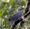 Nilgiri Wood-Pigeon


Notes
 Definitions from Wiktionary
 Media from Commons
 News from Wikinews
 Quotations from Wikiquote
 Texts from Wikisource
 Textbooks from Wikibooks
 Resources from Wikiversity
- ^ a b "The Peninsula". Asia-Pacific Mountain Network. Retrieved 2007-03-19.
{{cite web}}: Cite has empty unknown parameter:|1=(help); External link in|work= - ^ MYERS, N., R.A. MITTERMEIER, C.G. MITTERMEIER, G.A.B. DA FONSECA, and J. KENT. (2000) “Biodiversity Hotspots for Conservation Priorities.” Nature 403:853–858, retrieved 6/1/2007MYERS, N.
- ^ "The architects of peninsular geology". Deccan Herald. 2004-10-25. Retrieved 2006-12-02.
{{cite news}}: Check date values in:|date=(help); Unknown parameter|name=ignored (help) - ^ a b c "Biodiversity of the Western Ghats – An Overview". Wildlife Institute of India. Retrieved 2007-03-19.
{{cite web}}: Cite has empty unknown parameter:|1=(help); External link in|work=|name=ignored (help) - ^ "The Mining Sector – A Profile". Department of Geology and Mining, Government of Tamil Nadu. Retrieved 2007-03-19.
{{cite web}}: Cite has empty unknown parameter:|1=(help); External link in|work=|name=ignored (help) - ^ V.S. Vijayan. "Research needs for the Western Ghats" (PDF). Ashoka Trust for Research in Ecology and the Environment (ATREE). Retrieved 2007-06-21.
- ^ "Indian Dams by River and State". Rain water harvesting. Retrieved 2007-03-19.
- ^ "Tremors may rock Koyna for another two decade". Indian Express, Pune. 2005-10-03. Retrieved 2007-03-19.
{{cite news}}: Check date values in:|date=(help); Unknown parameter|name=ignored (help) - ^ UNESCO, MAB, (2007) World Heritage sites, Tentative lists, Western Ghats sub cluster, Retrieved 3/30/2007 [1]
- ^ Neyyar Wildlife Sanctuary[2]
- ^ Peppara Wildlife Sanctuary[3]
- ^ Shendurney Wildlife Sanctuary[4]
- ^ Achencoil, Kerala[5]
- ^ Konni, Kerala[6]
- ^ AGASTHYAVANAM BIOLOGICAL PARK, Kerala[7]
- ^ "zoologica" (PDF). Retrieved 2006-12-18.
- ^ Silas et al., (2005) Indian Journal of Fisheries, 52(2):125-140
- ^ Singh Mewa and Kaumanns Werner (2005) "Behavioural studies: A necessity for wildlife management", CURRENT SCIENCE, VOL. 89, NO. 7, October 10, p.1233.Full text
- ^ [8] Karnataka forest department (Forests at a glance -Statistics)
- ^ [9] Karnataka forest department (forests at a glance - Bio-diversity)
- ^ [10] The Nilgiri Bio-sphere Reserve.
- ^ Wildlife populations in Karnataka[11]
- ^ [12] Karnataka forest department, (forests at a glance -Statistics)
- ^ [13] Bhimgad awaits government protection
- ^ Michael Bright, 1001 Natural Wonders of the World by Barrons Educational Series Inc., Quinted Inc. Publishing, 2005.
- ^ Elamon Suresh (2006) "Kerala's Greatest Heritage", YouTube video, retrieved 4/29/2007 Kerala's Greatest Heritage
References
- Wikramanayake, Eric; Eric Dinerstein; Colby J. Loucks; et al. (2002). Terrestrial Ecoregions of the Indo-Pacific: a Conservation Assessment. Island Press; Washington, DC.
- Trek the Sahyadris Harish Kapadia
- Karnataka forest Department- National Parks and WLS
- R.J. Ranjit, Wildlife institute of India, "Biodiversity in the Western Ghats"
- Ajith Kumar, Salim Centre for Ornithology and Natural History, Coimbatore, India, Ravi Chellam, B.C.Choudhury, Divya Mudappa, Karthikeyan Vasudevan, N.M.Ishwar, Wildlife Institute of India, Dehra Dun, India, Barry Noon, Department of Fish and Wildlife Biology, Colorado State University, Fort Collins, U.S.A. (2002) "IMPACT OF RAINFOREST FRAGMENTATION ON SMALL MAMMALS AND HERPETOFAUNA IN THE WESTERN GHATS, SOUTH INDIA", FINAL REPORT, pp. 146, illus. Full textretrieved 3/14/2007
- List of Butterflies recorded from the Western Ghats
- Verma Desh Deepak (2002) "Thematic Report on Mountain Ecosystems", Ministry of Environment and Forests,13pp, retrieved 3/27/2007Thematic Report on Mountain EcosystemsFull text, detailed data, not cited.
- ABSTRACTS, Edited by Lalitha Vijayan, SACONR. Vasudeva, University of Dharwad, Priyadarsanan, ATREE, Renee Borges, CES, ISSC, Jagdish Krishnaswamy, ATREE & WCSP. Pramod, SACON, Jagannatha Rao, R., FRLHTR. J. Ranjit Daniels, CARE EARTH, Compiled by S. Somasundaram, SACON (1-2 December 2005) Integrating Science and Management of Biodiversity in the Western Ghats, 2nd National Conference of the Western Ghats Forum, Venue: State Forest Service College Coimbatore, Organized by Salim Ali Centre for Ornithology and Natural History, Anaikatty, Coimbatore – 641108, INDIA. Sponsored by Ministry of Environment and Forests, Government of India. Supported by The Arghyam Foundation, The Ford Foundation & Sir Dorabiji Trust Through Ashoka Trust for Research in Ecology and the Environment (ATREE)