
Caleta de San Lazaro: Difference between revisions
Tag: Reverted |
Tag: Reverted |
||
| Line 111: | Line 111: | ||
===Calle San Lázaro=== |
===Calle San Lázaro=== |
||
[[File:La Casa de Beneficencia y Maternidad de La Habana. Map of barrio San Lazaro, 1855.jpg|thumb|260px|right|Map of barrio San Lazaro showing Caleta de San Lazaro]] |
[[File:La Casa de Beneficencia y Maternidad de La Habana. Map of barrio San Lazaro, 1855.jpg|thumb|260px|right|Map of barrio San Lazaro showing the [[Caleta de San Lazaro]], Hospital of San Dionisio, the [[Espada Cemetery]], [[Hospital de San Lázaro, Havana|Hospital de San Lázaro]], [[La Casa de Beneficencia y Maternidad de La Habana|Casa de Beneficencia]], and the Torreón de San Lázaro]] |
||
During colonial times, Calle San Lázaro was one of the most important streets in Havana. It was known mainly for the various funeral processions that traveled down this important street to the [[Espada Cemetery]], the first cemetery of the city.<ref name="guide"/> |
During colonial times, Calle San Lázaro was one of the most important streets in Havana. It was known mainly for the various funeral processions that traveled down this important street to the [[Espada Cemetery]], the first cemetery of the city.<ref name="guide"/> |
||
Revision as of 22:16, 6 November 2021
| Caleta de San Lázaro | |
|---|---|
 Caleta de San Lázaro | |
 | |
| Former names | Caleta de Juan Guillén |
| General information | |
| Status | Filled in in 1902 |
| Location | West of Centro Habana |
| Town or city | Havana |
| Country | Cuba |
| Coordinates | 23°08′31″N 82°22′17″W / 23.141832°N 82.371513°W |
There was a path called Arcabuco in Havana that began in Old Havana in the vicinity of the Loma del Ángel that ran in a westerly direction to an inlet cove that was 93 meters wide and approximately 5.5 meters deep.[1] Eventually there were located there the Hospital de San Lázaro, the Espada Cemetery, the San Dionisio mental asylum, and La Casa de Beneficencia. When a Spanish soldier named Juan Guillén installed in the cove area a carpentry shop to build small boats, the site was called “La Caleta de Juan Guillén” and the road became known as “the caleta”.[2]
History
Calle San Lázaro

During colonial times, Calle San Lázaro was one of the most important streets in Havana. It was known mainly for the various funeral processions that traveled down this important street to the Espada Cemetery, the first cemetery of the city.[3]
Calle San Lázaro began to be populated in 1815, but the buildings situated in the area suffered the effects of several hurricanes in 1844 and 1846, respectively, and a flood on December 26, 1859. Among its most notable buildings was La Casa de Beneficencia y Maternidad de La Habana, the Hermanos Ameijeiras Hospital is built in the lot of the old Casa de Beneficencia. San Lázaro Street is of interest to the Office of the City Historian, which has implemented plans to renovate buildings situated there.[3]
Batería de la Reina


In the esplanade that today occupies the Antonio Maceopark, in front of the La Casa de Beneficencia y Maternidad de La Habana orphanage and the Hospital de San Lázaro, and opposite Marcos Lucio's Torreón de San Lázaro, built-in 1665, was a colonial military defense fortress that had accommodations for a garrison of 250 men and 44 pieces of artillery. The Bateria de la Reina was demolished at the beginning of the 20th century.
La Casa de Beneficencia y Maternidad

In 1794 La Casa de Beneficencia, located on land located in front of the Caleta de San Lazaro, an area known at that time as the Betancourt Garden, was the initiative of a group of illustrious Habaneros, including Luis de Peñalver, the Bishop of New Orleans, the Countess de Jaruco, the Marquise of Peñalver and Cárdenas, and the Captain-General, Luis de las Casas. Initially, La Casa de Beneficencia admitted only females.
The financial situation of La Casa de Beneficencia y Maternidad was difficult, sometimes distressing. Towards 1824, General Francisco Dionisio Vives took it out of its financial quagmire by providing a tax on lottery tickets and another on the cockfights that took place in the trenches of the Castillo de la Fuerza.
In 1914, President Mario García Menocal converted La Casa de Beneficencia into a state institution and provided it, without forgoing donations and popular collections, with a budget for maintenance. In the 19th century in what is now Maceo Park the Batería de la Reina was installed. Along Calle Belascoaín, at the back of the building and shown on an 1866 map, was the bullring of Havana.[4] On Calles Virtudes and Concordia, was the jai alai frontón.
In the late 1950s, the Batista government bought the building and demolished it with the intention of building the headquarters of the National Bank of Cuba.[5] The Revolution triumphed however and it was decided to install the children in what had been the Civic Military Institute, in Ceiba del Agua. The new facility was named Hogar Granma.[6]
Espada Cemetery

It was the custom of the people of Havana to bury the dead in a crypt inside of the churches, placing them according to their social rank and prices paid for the vault. (e.g. Cathedral of Havana and Iglesia del Espíritu Santo.)
The Espada cemetery was a garden type. A single wall contained the crypts. The design and construction were directed by an architect with the surname of Aulet. The cemetery had a central courtyard; the walls were approximately 6 meters tall (4 crypts) with an elaborate stone coping for protection from the rain. The paintings that adorned the entrance pavilion were by the Venetian Giuseppe Perovani (1765-1835). The cemetery was officially inaugurated on February 2, 1806. Only a small section of the original wall remains.
The Espada Cemetery was outside the jurisdiction of the church, built under the authority of the government of Don Salvador De Muro and Salazar, Marquis of Someruelos, who ordered that the General Cemetery of Havana be built between the Calles of San Lázaro, Vapor, Aramburu, and Espada. This public work was helped by the Bishop Juan José Díaz de Espada and Fernández de Landa under the auspices of the Governor, the City Council, and the Cathedral of Havana. The cemetery was located a mile west outside the walls of the City and near the cove of San Lazaro.[7]
After being officially called the General Cemetery of Havana and Campo Santo (Holy Field), it was renamed the Espada Cemetery in honor of the Bishop of Espada y Landa, whose hand was decisive for its establishment. The cemetery and the relocation of the corpses from the various churches were carried out by three black slaves with carts pulled by horses and financed with Bishop of Espada y Landa's own wealth.
The first remains taken to the new cemetery were those of the former Captain General Don Diego Manrique, which were exhumed from the church of San Francisco de Asís; as well as those of the Bishop of Milaza, José González Cándamo, who was governor of the miter of Havana, and who had been exhumed from Havana Cathedral. The bodies were gathered at the chapel of the Casa de Beneficencia. The corpses were transferred in black velvet boxes distinguished with gold trimmings.[8]
Hospital de San Lázaro

When the Hospital de San Lázaro was built in the vicinity of the cove in 1781 under the auspices of the Catholic Church, the name of the area changed. The area and the old road were renamed “the one of Saint Lazarus”. Later officially it was named Calle Ancha del Norte.[2] The City Council of Havana, on November 17, 1905, changed the name from Calle Ancha del Norte to Avenida de Maceo, in 1909, again by another agreement, the number 204 of the same entity, dated December 6, a new name was determined for the street, that of Avenida de la República. Since it was not a significant street, it was understood by the relevant entities and by the inhabitants of the city, that this name was not correct. For this reason, it was decreed to restore that of San Lázaro, from the Paseo de Martí to the University.[2]
Stretching 14 blocks, Calle San Lázaro was named from the San Lázaro Hospital. It was known as Calle del Basurero by the inhabitants of the city.[3]
Torreón de San Lázaro

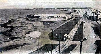
The Torreón is a cylinder, a round tower of masonry. It is approximately 4.57 metres (15.0 ft) in diameter and 9.14 metres (30.0 ft) high with embrasures along its wall at the intermediate level and a battlement parapet at the third level roof.[1] It has a wooden entry door at ground level. With the passage of time, the San Lazaro cove was filled and the tower was included in a Republican-era park named after Major General Antonio Maceo. In an 1853 map of Havana it is shown as the Torreón de Vijias (lookouts).[9] In 1982, the Torreón was inscribed along with other historic sites in Old Havana on the UNESCO World Heritage List, because of the city's importance in the European conquest of the New World and its unique architecture.[10]
Located in the Parque Antonio Maceo at Malecón and Calle Marina in present-day central Havana is the Torreón de San Lázaro, a watchtower built-in 1665 by the engineer Marcos Lucio. From this fortification a lookout could warn military forces by way of torches of threats of attack by corsairs and pirates. In this regard, it served as a link in the defense chain between the Batería de la Reina, La Punta, and the Santa Clara Battery located at the site of today's Hotel Nacional.[11]
The Torreón de San Lázaro is named for the nearby leprosarium at the Hospital de San Lázaro which was near the cove formerly known as the Cove of Juan Guillén.
Havana Jai alai

There is an abandoned Jai alai court[12] in the back of the Hermanos Ameijeiras Hospital, the site of the old Casa de Beneficencia, on Calles Concordia and Lucenas near Calle Belascoain, an area that had been considered in the early part of the city as a place to locate the helpless and the unwanted (Casa de Beneficencia, Hospital de San Lázaro, the Espada Cemetery, Casa de Dementes de San Dionisio), it was the edge between the city and the countryside;[13] the spectator stands were parallel to Calle Concordia, the front wall of the court faced Calle Lucenas, East in the direction towards Old Havana. The original building has been annexed by five stories of residential concrete construction on the Northside along Calle Virtudes.[14] The Havana Jai alai fronton was known as "the palace of screams" (Spanish: el palacio de los gritos).[15]
Dredging the Caleta of San Lazaro

In 1916 the dredging of the Caleta of San Lazaro began, but in September 1919 a cyclone hit Havana and the rise in sea level raised the inland stretch that had been artificially created, the flood almost reached the Casa de la Beneficencia. In 1921, dredging was resumed and the construction of the Malecón wall began from the Torreón de San Lázaro to the current 23rd Street, the section was completed in 1923.[16]
Gallery
-
 Map of Habana in 1866
 -
 Map of 1900 showing the Caleta de S. Lazaro
 -
 Map of Habana in 1853
 -
 Batería de la de la Reina
 -
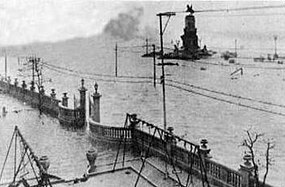 La Casa de Beneficencia y Maternidad during the hurricane of 1919.
 -
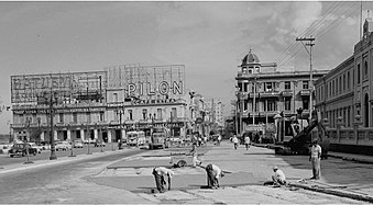 Barrio de San Lázaro. Vista Alegre Cafe. ca 1940.
 -
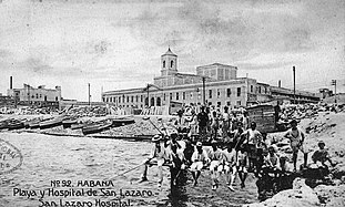 Hospital de San Lázaro, founded in 1781, showing Caleta de San Lazaro


See also
References
- ^ "MALECON – BATERIA DE LA REINA". Retrieved 2021-11-06.
- ^ a b c "Calle de San Lázaro". Retrieved 2021-11-06.
- ^ a b c "Calle San Lázaro Famous Street". Retrieved 2021-11-06.
- ^ Plano de La Habana [circular reference]
- ^ "Castro Inaugurates Centro Habana Hospital". Retrieved 2018-12-15.
- ^ "Casa de Beneficencia y Maternidad". Archived from the original on 2018-12-15. Retrieved 2018-12-15.
- ^ "El Cementerio de Espada". Archived from the original on 2018-12-15. Retrieved 2018-12-14.
- ^ "El Cementerio Espada: Primer cementerio de Latinoamérica fuera de una iglesia". Archived from the original on 2018-12-14. Retrieved 2018-12-14.
- ^ Plano pintoresco de La Habana [circular reference]
- ^ {{cite web |url = http://whc.unesco.org/en/list/204} |title = Old Havana and its Fortification System |website = UNESCO World Heritage Centre |publisher = United Nations Educational, Scientific, and Cultural Organization |access-date = 26 May 2021}
- ^ "Forts of Cuba". Archived from the original on 2018-12-17. Retrieved 2018-12-16.
- ^ "Frontón Jai Alai: Inside Havana, Cuba's "Palace of Screams"". 7 January 2020.
- ^ "Andar tras las huellas de Tacón". 27 March 2019. Retrieved 2021-10-27.
- ^ https://www.fotosdlahabana.com/wp-content/uploads/2021/01/Virtudes-y-Belascoain.jpeg
- ^ "El Frontón Jai Alai, la historia del Palacio de los Gritos". Retrieved 2021-10-28.
- ^ "Cayo Hueso: Con la vista fija en un lugar de Centro Habana". Retrieved 2021-11-06.
- Buildings and structures in Havana
- Streets in Havana
- Wards of Havana
- History of Havana
- Historic districts
- Spanish colonization of the Americas
- Culture in Havana
- Urban planning by country
- 20th century in Havana
- 19th century in Havana
- People of the Ten Years' War
- Cuban soldiers
- Spanish soldiers
- Hospitals in Cuba
- Buildings and structures completed in 1781
- Hospital buildings completed in the 18th century
- 18th-century establishments in Cuba
- Neoclassical architecture in Cuba
- Cartography by continent
- Historic maps of the world