
Wikipedia:Graphics Lab/Illustration workshop
The Graphics Lab is a project to improve the graphical content of the Wikimedia projects. Requests for image improvements can be added to the workshop pages: Illustrations, Photographs and Maps. For questions or suggestions one can use the talk pages: Talk:Graphics Lab, Talk:Illustrations, Talk:Photographs and Talk:Maps.
This specific page is the requests page for the illustration workshop. Anyone can make a request for an illustration to be improved or created for a Wikipedia article. Clicking the "New Request" button will bring you to a standard template for submitting requests, as well as general advice that should be followed.
| Advice to requesters |
|---|
|
All requests:
SVG requests:
|
|
Requests from recent years:
| |
| For graphists: |
| If you have completed work and not received a reply you may use the {{GL Illustration reply}} template to inform the requester. |
| Graphists and other visitors to the Graphic Lab may be interested in the RSS feed of changes to this page. You may find it here. |
SATA Express connectors
Article(s): SATA Express
Request:
- Any chances, please, for SVG versions of the SATA Express connectors, as visible on page three in this PDF file? SVG drawings of those five connectors would be a great addition to the article; if possible, those should be five separate drawings. The article deals a lot with explaining those connectors and their backward compatibility, so images would be very helpful. Thank you! — Dsimic (talk | contribs) 19:15, 4 April 2014 (UTC)
Graphist opinion(s):
- I just took a look at the PDF. Those are already vector images so SVGs are easy to make from the PDF. However, virtually everything on that website is under copyright so I am playing it safe by saying those images are probably not licensed for free (or near free) use. Also, I don't think they belong on Wikipedia either as free versions can be created and/or obtained which negates the fair use principle. Might I suggest that you find patents for the connectors and use the images from those instead? Those would be in the public domain (as all U.S. patent images are) and down the road SVGs could be made based on them. Or, you could contact SATA IO to see if those images can be Creative Commons licensed or released into the public domain. The Haz talk 21:14, 4 April 2014 (UTC)
- Thank you for an insight! Unfortunately, I'm having troubles finding actual patents so far; would this PDF (reached through http://www.sffcommittee.org/ie/) be any better instead? On pages 12 and 13 it covers some of those five connectors, and there are more similar technical specifications covering the rest. Please advise. — Dsimic (talk | contribs) 01:33, 5 April 2014 (UTC)
- @Hazmat2: Any updates, please? — Dsimic (talk | contribs) 03:42, 10 April 2014 (UTC)
- @Dsimic: I found a patent, but there is only a drawing of one or two connectors (I can't really tell) [1] Sn1pe! (talk)(edits) 18:29, 26 April 2014 (UTC)
- Thank you for finding the patent, but unfortunately available pictures of connectors aren't that usable for the SATA Express article. They serve purely as simplified illustrations for the patent, and unfortunately wouldn't be that good for the article. Sigh. :(
- At the same time, please have a look at SATA Express motherboard connection request below. — Dsimic (talk | contribs) 20:45, 26 April 2014 (UTC)
-
Promo single cover
Article(s): Masterpiece (Madonna song)
Request:
- Please help me to vectorize this picture. And if possible, please restore its original colour, like this or this one. This is another raw example of this single cover. -- Bluesatellite (talk) 00:05, 5 April 2014 (UTC)
Graphist opinion(s): Just a heads up to ///EuroCarGT your Madonna file looks to be missing the request "to restore the color" . - FOX 52 (talk) 01:09, 5 April 2014 (UTC)
- @FOX 52: I know, the software wasn't coping with me :(. ///EuroCarGT 01:11, 5 April 2014 (UTC)
- Hate to say it but a re-draw maybe in order, the program has distorted the image somewhat (upon closer inspection) - cheers FOX 52 (talk) 01:15, 5 April 2014 (UTC)
- @FOX 52: Maybe you give it a try? Two hands are better than one!
 ///EuroCarGT 01:16, 5 April 2014 (UTC)
- @FOX 52: Maybe you give it a try? Two hands are better than one!
- Hate to say it but a re-draw maybe in order, the program has distorted the image somewhat (upon closer inspection) - cheers FOX 52 (talk) 01:15, 5 April 2014 (UTC)
 Done ///EuroCarGT 00:27, 5 April 2014 (UTC)
- I'll see what I can do - FOX 52 (talk) 03:56, 5 April 2014 (UTC)
Indian Council of States by party composition
-
 Please design it similarly to this example for the lower house
 -
 This simplified design also could work if the former is too tedious
 -
 Rings
Rings


Article(s): Rajya Sabha (upper house)
Request:
- Please create a graphic distribution of the 245 seats in the upper house. The list of MPs for the upper house is as follows: -- RaviC (talk) 11:43, 6 April 2014 (UTC)
Members by Party Source: Election Commission of India[2] (as of 03/02/2014)
| Sno | Party | Strength |
|---|---|---|
| 1 | Asom Gana Parishad (AGP ) | 1 |
| 2 | All India Anna Dravida Munnetra Kazagham (AIADMK ) | 10 |
| 3 | ALL INDIA TRINAMOOL CONGRESS (AITC ) | 12 |
| 4 | Biju Janata Dal (BJD ) | 7 |
| 5 | Bharatiya Janata Party (BJP ) | 46 |
| 6 | Bodoland People's Front (BPF ) | 1 |
| 7 | Bahujan Samaj Party (BSP ) | 14 |
| 8 | Communist Party of India (CPI ) | 2 |
| 9 | Communist Party of India (Marxist) (CPI(M) ) | 9 |
| 10 | Dravida Munnetra Kazagham (DMK ) | 5 |
| 11 | Indian National Congress (INC ) | 67 |
| 12 | Independent & Others (IND. ) | 9 |
| 13 | Indian National Lok Dal (INLD ) | 1 |
| 14 | J&K National Conference (J&KNC ) | 2 |
| 15 | Janta Dal (United) (JD(U) ) | 9 |
| 16 | Jharkhand Mukti Morcha (JMM ) | 1 |
| 17 | Kerala Congress (M) (KC(M) ) | 1 |
| 18 | Lok Janasakti Party (LJP ) | 1 |
| 19 | Mizo National Front (MNF ) | 1 |
| 20 | Nationalist Congress Party (NCP ) | 6 |
| 21 | Nominated (NOM. ) | 10 |
| 22 | Nagaland People's Front (NPF ) | 1 |
| 23 | Republican Party of India (A) (RPI(A) ) | 1 |
| 24 | Shiromani Akali Dal (SAD ) | 3 |
| 25 | Sikkim Democratic Front (SDF ) | 1 |
| 26 | Samajwadi Party (SP ) | 9 |
| 27 | Shiv Sena (SS ) | 3 |
| 28 | Telugu Desam Party (TDP ) | 4 |
Graphist opinion(s):
- I have created the necessary diagram, but I could do with some help with the colouring. The legend from the lower house image is below:
- Unfortunately, I can't seem to line up some of the acronyms, and the ordering on the other image seems to have some political logic behind it, so I wouldn't know where to insert the parties that don't appear. If you could help me out by editing the legend posted above to remove parties with no members in the upper house, and adding in new parties in appropriate places (if you want to choose colours for these, go ahead, but I can do that if not) then I can populate the picture. NikNaks talk - gallery 19:02, 5 May 2014 (UTC)
- Hello there, thank you for helping out with the request. Here is my edited version, sorted by the political alliances of the parties. Please let me know if you need any more information. --RaviC (talk) 21:12, 5 May 2014 (UTC)
- United Progressive Alliance (UPA)
Kerala Congress (M) (KC(M))
- Third and Fourth Front / Unaligned regional parties
Asom Gana Parishad (AGP)
Mizo National Front (MNF)
Bodoland People's Front (BPF)
Indian National Lok Dal (INLD)
Jharkhand Mukti Morcha (JMM)
Sikkim Democratic Front (SDF)
- National Democratic Alliance (NDA)
Shiromani Akali Dal (SAD)
Nagaland People's Front (NPF)
Republican Party of India (A) (RPI(A))
Lok Janasakti Party (LJP)
- Independents and others
- Nominated (NOM.)
- I will add additional colours for the remaining parties (currently marked in pink on the image) tomorrow at some stage. However, I'm slightly concerned that there only seem to be 237 seats accounted for on your list and, confusingly, 241 on the website you've linked to. I've therefore left eight seats blank (white with the black outline), but if there's some error in the list then please do let me know and I can rearrange some seats. NikNaks talk - gallery 23:13, 5 May 2014 (UTC)
- Aaaah, I understand now! The one seat parties are all grouped together on the lower house image. Unless you want something different, I'll do the same for this one. NikNaks talk - gallery 23:22, 5 May 2014 (UTC)
- Thanks, this looks great. I really appreciate it. --RaviC (talk) 05:05, 6 May 2014 (UTC)
- Aaaah, I understand now! The one seat parties are all grouped together on the lower house image. Unless you want something different, I'll do the same for this one. NikNaks talk - gallery 23:22, 5 May 2014 (UTC)
![]() Done NikNaks talk - gallery 12:54, 6 May 2014 (UTC)
Done NikNaks talk - gallery 12:54, 6 May 2014 (UTC)
File:Flag of the Mughal Empire.png
-
 Please vectorise
 -


.svg)
Article(s): Flag of the Mughal Empire
Request:
- Please vectorise (note that the tips on the corners are slightly cut off, my mistake). Source material are here [3] and [4]. Also, some minor corrections need to be done on the arrangements of the stars, the line of stars running towards the hypotenuse are not parallel to it (the ones running along the adjacent and opposite are parallel however). Please modify so that the stars towards the hypotenuse run parallel as well, you will need to slightly shift all the stars basically. The lion also needs to be slightly shifted a bit more away from the adjacent towards the centre, so that is become the median. Upload new version under this file File:Flag of the Mughal Empire.svg, since the creator himself expressed doubt about the authenticity of the version. Thank you. -- Gryffindor (talk) 22:02, 6 April 2014 (UTC)
Graphist opinion(s): Any good? I can add more stars if you like, just let me know. NikNaks talk - gallery 22:52, 2 May 2014 (UTC)
- The svg should be identical in all aspects as the png but with the stars properly aligned. The triangle does not have the same dimensions as the png. The sun and the lion are not the same size as in the png and is tilting upwards, the sun has too many rays. The name of the file is also wrong, there was never a rectangular Mughal flag, the flag is always triangular. Gryffindor (talk) 07:30, 3 May 2014 (UTC)
- No, thank you. Forgive me if I'm wrong, but there is no "official" flag that we can compare to here, only an interpretation, so I really don't see why you're being so critical of minor differences between this and the PNG (which I assumed was just your interpretation). Regardless, I'll rotate the emblem and make it smaller and remove those rays.
- As for the other things you've mentioned, I don't understand what you mean about the dimensions. As an SVG, you can scale it however you want with no loss of quality. I only picked a multiple of 300 so it would be easy to line up the emblem. I also felt it would be silly to waste a good image (albeit an ahistorical one) by overwriting it, hence the new name of the upload. I would recommend renaming the current one, and then moving the more accurate one to the old name. NikNaks talk - gallery 13:47, 3 May 2014 (UTC)
PDF Extraction
Article(s): Guelph Police Service
Request:
- Can someone extract the logo in this PDF? I'm having troubles... -- Connormah (talk) 04:35, 8 April 2014 (UTC)
Graphist opinion(s):
 Request taken by SiBr4. Extracting an SVG from a PDF itself isn't hard in Inkscape, but it often results in unmanageable SVG files. I'm now trying to reduce the file.
- What do you want to do with the logo when it's done? It's probably copyrighted and can only be used on WP as a non-free file. SiBr4 (talk) 09:42, 8 April 2014 (UTC)
- Just a standard nonfree upload to replace the lead image in the article listed above, I think. Connormah (talk) 03:18, 9 April 2014 (UTC)
- It should be non-free. Even you've uploaded File:Toronto Police Service Logo.svg nearly 5 years ago with a non-free file. ///EuroCarGT 03:26, 9 April 2014 (UTC)
- I now have the greater logo including the repeated name "Guelph Police Service" and motto "Pride Service Trust", though the current raster image only includes the shield with surrounding leaves, crown and motto. Should I keep the logo as it appears in the PDF or only the heraldic parts of it? SiBr4 (talk) 08:51, 9 April 2014 (UTC)
- Pinging the original requester Connormah. I have the greater logo ready; I can easily remove some parts to keep only the logo as it appears in the GIF file if that's what you want. SiBr4 (talk) 20:12, 13 April 2014 (UTC)
- Just a standard nonfree upload to replace the lead image in the article listed above, I think. Connormah (talk) 03:18, 9 April 2014 (UTC)
Southern Ocean Waters
-
 Map of water bodies around Antarctica
 -
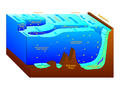 Cross-section of water bodies around Antarctica
 -


Article(s): The cross section is used on dozens of pages in the English Wikipedia alone; the map view, on four en pages (Oceanography, Ross Gyre, Southern Ocean, Weddell Gyre).
Request: The simple request: Could someone please convert these to SVG?
The complex one: For a really superb job, you could also combine the vertical section and horizontal map into a single illustration (for instance, a box with a quarter removed to show a section). I'm happy to check this for accuracy, so don't worry if you aren't sure of the details (there is a description of some of the information in the graphs on Wikipedia).
A warning, I had a go, and this does seem a bit difficult with the standard toolkit: How to do an isomorphic projection in Inkscape using grids, How to do a (2-point) projection in Inkscape using objects.
For an absolutely immaculate job, could you please make something that is clear to colourblind viewers? HLHJ (talk) 12:26, 10 April 2014 (UTC)
Graphist opinion(s):
- I would really like to work on this but to start with, this link How to do an isomorphic projection in Inkscape using grids is dead. Here are two places with some similar tutorials; mbeckler and kalaalog and I haven´t really checked them out.
- Now for your request. I can't really see what you mean by the "The complex one". How did you imagine that it would look. I can't really see how they could be combined into one illustration. The only way (to me at this time) is to turn your first image "Map of water bodies around Antarctica" into an Isometric projection, is that what you mean?.
- Or do you mean two illustrations in one image. If you have an idea I would really appreciate if you could do a very rough sketch just so I understand and don't put in a lot of hours for no use. Get back to me and we will take it from there, thanks. --Goran tek-en (talk) 17:52, 11 April 2014 (UTC)
- HLHJ I would need to get in touch for this request. I can't really understand what you mean as you can see above.
- Look at this link. It's a very simple sketch just to see if that is what you mean and then the cross-section should be added into it.
- I then need to know how that cross-section fits in. Where should the right hand side of that image go, in the center or where?
- Where should the left side of the cross-section go?
- I'm sorry that I don't understand you and if someone else does, please go a head and Take this request. --Goran tek-en (talk) 17:09, 13 April 2014 (UTC)
- HLHJ I would need to get in touch for this request. I can't really understand what you mean as you can see above.
More details
My apologies for the horribly unclear request, and the delay in replying; I've been offline. I did make a sketch, but I'm not sure how to upload it. Please keep questioning until I become clearly comprehensible; I don't want to waste your time.
The link now works for me; maybe it only went down briefly?
You can put the cross-section wherever you like, as long as it runs roughly northwards from Antarctica. The easiest option is to run it through the Atlantic. You could also do two sections, as in the example below.
Example Cutaway
Here is a sector cutaway of the Arctic and North Atlantic Oceans in an irrelevant context.

If the shape that is cut away is a simple cube or sector, that would work.
Physical reality and how it can be mapped
I did mean combining the two illustrations into one image. The strong currents that run around Antarctica make the water masses, approximately, concentric toroids (they have, very roughly, n-fold rotational symmetry, or rotational invariance, like a set of concentric circles or nested concentric cylinders). So you can show most of the 3-D structure with just two sections, a horizontal one across the surface and a vertical one through the pole.
The idea is for a diagram where the edges of the water bodies can be traced from the horizontal to the vertical plane, and easily imagined in 3-D. The rest of the details below are for purposes of illustration, please don't take them as binding.
Conceptual steps in making the cutaway view I have in mind
- make a wide, flat box, ratio 3:3:1 or similar, in a two-point perspective or similar
- put the map (first image, of Antarctica and the Southern Ocean from the above) on the large 3x3 top face of the box
- cut away part of the box, to show a vertical cross-section running directly away from the pole, along a meridian.
- put the cross-sectional view of the water masses (second image) on that vertical plane
Lining up the images


I've realized that the two images show somewhat different terminology. I'll try and reconcile them. I'm assuming the reader knows nothing about the subject; I hope you won't take offence if you already know.
Let's start with the atmospheric features. Three winds are relevant, but not shown on either diagram: the polar easterlies, the midlatitude westerlies, and the subtropical easterlies. These winds are caused by atmospheric circulation cells not shown in either diagram (see additional figures in margin).
Two main surface currents are caused by the winds. The Eastwind Drift (often called the Antarctic Coastal Current) is driven by the polar easterly winds. The much larger Antarctic Circumpolar Current (West Wind Drift) is driven by the midlatitude westerlies. These are only shown on the cross-section.
Moving on, there's the surface water divergences and convergences. Wind moves the surface of the water downwind, but it moves the bulk of the water sideways (counterintuitive though this may sound). In the southern hemisphere, it moves it leftwards if you are facing downwind (Ekman transport).
The Antarctic Coastal Current and Antarctic Circumpolar Current therefore move water away from each other, creating the Antarctic Divergence. Because the waters at the surface diverge, the deeper waters move up. So the Antarctic Divergence is a line around Antarctica where there is upwelling. It hugs the coat quite closely. The Antarctic Divergence is on the cross-section, but not shown on the map. There is a map from a 1942 textbook, presumably out of copyright; the page also includes a cross-section of the Antarctic Ocean.
A non-free, I think, external map of the Antarctic Divergence: http://www.eoearth.org/view/article/150097/
For clarity: the Antarctic Coastal Current (about 8 Sverdrups) lies south of the Antarctic Divergence, and the Antarctic Circumpolar Current (100-150 Sverdrups) lies north of it. They go in around the continent in opposite directions.

The Antarctic CONvergence, on the other hand, lies further north. It is sometimes thought of as the border of the Antarctic Ocean. Apcbg has made a map of it (see additional figure). It lies where the northward ekman transport of the midlatitude westerlies meets the southward ekman transport of the subtropical easterly trade winds. These water motions CONverge at the surface, and create an DOWNwelling between them, as the colder water sinks. This is labelled on both diagrams as the Polar Front. I think this is confusing, as polar front is the name for the place where the atmospheric winds meet (the polar easterlies and the midlatitude westerlies). True, the Antarctic Convergence is caused by the atmospheric polar front, and the two roughly coincide, but I think labelling them separately is clearer. Since changing a label on an SVG is easy, the choice of term isn't critical.
A good diagram of divergence and convergence in abstract: https://www.e-education.psu.edu/earth103/node/705
The two lines on the cross-section's sea surface to the left of the polar front correspond to the two fronts north of the polar front on the map.
The Subtropical Zone, orange on the map, has warm, salty surface waters. South of it is the Subtropical Front, also called the Subtropical Convergence. Between the Subtropical Convergence and the Antarctic Convergence, there seems to be an area of active research :).
The north side of this area is the Subantarctic Zone (yellow). This zone ends, to the south, in the Subantarctic Front. The Subantarctic Front is usually defined as the area where the temperature goes from 4 Celsius to 8 Celsius. It is a surface divergence and an area of upwelling. The area to the south, which is colder than 8 Celsius, is labelled on the map as the Polar Frontal Zone (green).
Moving below the ocean surface, we come to the water masses. Each of them has a characteristic temperature and salinity (often mapped on cross-sections, along with oxygen content, density, potential temperature, potential vorticity, and the presence of tracers). The boundaries are a bit fuzzy, though, and a search for a few versions of the cross-section diagram online brings up slightly different categorizations.
None of the water masses are explicitly labelled on the map, but the Subtropical Surface Water is in the Subtropical Zone, and the Subantarctic Surface Water in the Subantarctic and Polar Frontal Zones. I'd drop the "zone" labels and just label the water masses.
Everyone seems to agree that the Subantarctic Zone has, at the surface, Subantarctic Surface Water. On cross-sections other than this one on Wikipedia the Polar Frontal Zone usually contains a different water mass, variously called the Subantarctic Intermediate Water, the Circumpolar Surface Water, and the Antarctic Intermediate Water; but there seem to be grounds for considering it just more Subantarctic Surface Water. I think we should ask Hgrobe about this, because I am not sure what the best classification is, and I suspect it may change (his figure is from 2000, and there has been substantial research in this area since).


List of water masses:
- Antarctic Intermediate Water
- Antarctic Bottom Water
- Circumpolar Deep Water
- North Atlantic Deep Water
- Antarctic Surface Water
- Subantarctic Surface Water (also called Subantarctic Mode Water)
- Subtropical Surface Water (see Subtropical Front)
Cross-section location
The cross-section shows a section through the Atlantic. That's why it shows the North Atlantic Deep Water, which has sunk in the North Atlantic and flowed under the intermediate waters all the way south. As it gets into the Southern Ocean, the Antarctic Circumpolar current whips it into a ring, right around the continent; this ring is called the Circumpolar Deep Water (and it is a bit different from North Atlantic Deep Water; it gets colder, for starters). The Antarctic Deep Water and the surface waters exchange somewhat with all three basins (Pacific, Atlantic, Indian).
You may or may not want to put the cross-section along the middle of the Atlantic. I think most of the diagrams I've seen do, probably because the Atlantic is narrow and well-studied and contains North Atlantic Deep Water, but that's not to say it mightn't be useful to do a cross section in the Pacific or Indian Ocean, or one to Australia or Africa. If you want to run your cross-section through the Ross or Weddell Gyres, we'll need a section of them -- as far as I know, they are spinning columns of water that go all the way down to the sea floor, which is probably all the detail you need. If you want to run your cross-section through the Pacific or Indian Oceans, we'll need a north-to-south cross-section of the ocean. The best ones are probably in Oceanography or Earth Systems Science textbooks. Some charts on the web:
A cross-section of the Southern Ocean to New Zealand The IODP say "Material in this publication may be copied without restraint for library, abstract service, educational, or personal research purposes; however, republication of any portion requires the written consent of the Director, Ocean Drilling Program, Texas A&M University Research Park, 1000 Discovery Drive, College Station, Texas 77845-9547, U.S.A., as well as appropriate acknowledgment of this source.", so I suspect they'd give permission to use this.
A cross section of the Southern Ocean, on slide 19 (uses multiple conventions without description).
A good article on the cross-sectional water structure of the Atlantic.
A misc. collection of assorted oceanography maps.
An ambitious attempt to map cross-sections of flows in all three basins at once.
Truly ugly but informative simplified cross-sections of the Atlantic, Pacific, and Indian Oceans:

An external cross-section of the Arctic Ocean, to compare to the one in the margin: http://www.nature.com/ngeo/journal/v4/n1/fig_tab/ngeo1044_F1.html

Sea floor
If you line up each of the features, the only other problem is the sea floor. The coast is located on the map; the shelf and the midocean ridge, if you show it, should be located wherever a bathymetric chart says it is, which will vary depending on where you put your section. The gravity-based map in the margin does not show the mid-ocean ridge or the shelf very clearly, but the seafloor-age one does. Paul V. heinrich has made an excellent bathymetric chart of Antarctica (see margin); perhaps he, or his data, could help?
If you run the cross-section through an ice shelf, you will need to show that. Showing the seasonal sea ice might also be good. I can tell you what latitude it extends to at any give longitude.
HLHJ I'm totally impressed on all the information you provided me with and I think I'm starting to understand you, and I know nothing of this subject (I'm learning so much for every map or illustration I work on, it's great).
Unfortunately there is no way to upload a work in progress image here on any WM site so you have to contact me by email and then you can attatch it there for me.
![]() Request taken by Goran tek-en (talk) 17:02, 17 April 2014 (UTC).
I will now start to work on the basic image and show you drafts as the work progresses so I will be back, thanks. --Goran tek-en (talk) 17:02, 17 April 2014 (UTC)
Request taken by Goran tek-en (talk) 17:02, 17 April 2014 (UTC).
I will now start to work on the basic image and show you drafts as the work progresses so I will be back, thanks. --Goran tek-en (talk) 17:02, 17 April 2014 (UTC)
- HLHJ Now you can look at this link but you probably have to reload the page to get the new image.
- This is a FIRST DRAFT just so we can agree on; type of projection, area, rotation and so on. This is a handmade projection so it's not perfect or the absolute truth (which map is really) in any sense. If you need that then I'm not the person for this.
- Get back to me with feedback if this is something to work from and/or what you want different and I will see if I can achieve that for you. You have to be honest, it's your request and only you know what you are looking for. I want a straight open communication, thanks. --Goran tek-en (talk) 19:01, 17 April 2014 (UTC)
- Hello, Goran tek-en, and thank you very much for the first draft. It looks like the right sort of thing, the area and projection look suitable. One thing I don't understand from the draft is where you intend to put the cross-section(s).
- I would not worry about perfection. Since all of the water boundaries move around, and some are rather poorly-measured or ill-defined, immense precision is not really useful or possible. It's a schematic, not a graph of measurements.
- If you would like SVG files showing the coastlines, I can create them using R and send them to you. If you need a quicker response, please e-mail me.HLHJ (talk) 14:29, 20 April 2014 (UTC)
- HLHJ This was just to get a first look at the surface part to check boundaries etc. This png comes from my svg file and is just to show you, I have so many different maps within the svg now in working mode so it was easier to render a png to show. Of course I do this in svg.
- I think it's good for you to know my working plan for this;
- First I will do the surface in a flat projection as that is much easier.
- When that is accepted by you I will add the isometric projection to that and then add the cross-section, so it's position is not decided yet.
- So now I will make the surface and get back to you for feedback ones that's done. I have to tell you that most of next week is really busy for me so I will probably not have any time for this, just so you know. --Goran tek-en (talk) 16:05, 20 April 2014 (UTC)
- HLHJ This was just to get a first look at the surface part to check boundaries etc. This png comes from my svg file and is just to show you, I have so many different maps within the svg now in working mode so it was easier to render a png to show. Of course I do this in svg.
- Thanks, Goran tek-en. Sorry, I know you do lots of SVGs, I just wanted to check you didn't lack data that I have. I think your plan sounds good. It might be easier to take the missing chunk out the flat projection before rotating it. I'm going to be pretty busy the next couple of weeks, too, so no problem.HLHJ (talk) 16:36, 20 April 2014 (UTC)
- If you would like SVG files showing the coastlines, I can create them using R and send them to you. If you need a quicker response, please e-mail me.HLHJ (talk) 14:29, 20 April 2014 (UTC)
Indian election map
-
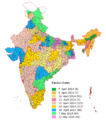 Need a plain, black & white PNG version of this map

Article(s): Various
Request:
- I intend to create various maps on the outcome of the Indian general election, 2014, but for that I need a blank version of the constituency map, with only the constituency borders and numbers. -- Soman (talk) 09:44, 14 April 2014 (UTC)
Graphist opinion(s):
- Why not use a SVG-map? Wereldburger758 (talk) 20:12, 14 April 2014 (UTC)
- I only use Paint. --Soman (talk) 20:45, 14 April 2014 (UTC)
- I wish I could help you out. But I my os runs on a 486 and cannot handle files that large. I ask the map-section for help. Wereldburger758 (talk) 07:06, 15 April 2014 (UTC)
- Dear Soman, it will be better if you use inkscape to handle these vector images (.svg file). Wikimedia prefer vector image rather than raster image. I can make black and white raster (.jpg) version of this image for you. But that will be similar as making a pull cart from Toyota car! --FreemesM (talk) 10:26, 16 April 2014 (UTC)
- I downloaded Inkscape, trying to blank it piece by piece, but I have the problem that shades of the old colors remain at the fringes of the borders. Also note that the borders of the 2009 map are no longer in effect, so I removed that image. --Soman (talk) 11:33, 16 April 2014 (UTC)
- Dear Soman, I found this vector image in commons. Please check it- [6] It seems similar as your reference image, but has black background. I can remove the black background, will it meet your necessity? I have made a sample for you [7]. If it works, please let me know, I will upload it on wikimedia commons in .SVG format. Which you can easily edit by using Inkscape. You can check these too [8]--FreemesM (talk) 05:03, 18 April 2014 (UTC)
- I downloaded Inkscape, trying to blank it piece by piece, but I have the problem that shades of the old colors remain at the fringes of the borders. Also note that the borders of the 2009 map are no longer in effect, so I removed that image. --Soman (talk) 11:33, 16 April 2014 (UTC)
- Dear Soman, it will be better if you use inkscape to handle these vector images (.svg file). Wikimedia prefer vector image rather than raster image. I can make black and white raster (.jpg) version of this image for you. But that will be similar as making a pull cart from Toyota car! --FreemesM (talk) 10:26, 16 April 2014 (UTC)
- I wish I could help you out. But I my os runs on a 486 and cannot handle files that large. I ask the map-section for help. Wereldburger758 (talk) 07:06, 15 April 2014 (UTC)
- I only use Paint. --Soman (talk) 20:45, 14 April 2014 (UTC)
SATA Express motherboard connection

Article(s): SATA Express
Request:
- Any chances, please, for SVG version of a SATA Express motherboard connection, as visible on this image from this web page? SVG drawing of this motherboard connection would be a great addition to the article; I don't think that's copyrighted stuff. The article deals a lot with explaining SATA Express connectors and their backward compatibility, so this image would be very helpful. Thank you! — Dsimic (talk | contribs) 01:58, 25 April 2014 (UTC)
Graphist opinion(s):
- How's this? NikNaks talk - gallery 18:33, 6 May 2014 (UTC)
- Simply awesome, thank you very much! As before, more details are available on my talk page. — Dsimic (talk | contribs) 21:15, 6 May 2014 (UTC)
M.2 edge connector keying

Article(s): M.2
Request:
- Any chances, please, for SVG version of M.2 edge connector keying options, as visible on this image from this web page? SVG drawing of these keying options would be a great addition to the article; I don't think that's copyrighted stuff. The article deals a lot with explaining the keying and M.2 module types, so this image would be very helpful. Thank you! — Dsimic (talk | contribs) 07:00, 28 April 2014 (UTC)
Graphist opinion(s):
- Done NikNaks talk - gallery 20:13, 5 May 2014 (UTC)
- Awesome, thank you very much! I've provided more details on my talk page. — Dsimic (talk | contribs) 07:01, 6 May 2014 (UTC)
Grand Prix
-
 The 1st image
 -
 The 2nd image


Article(s): Various
Request:
- Please vectorise these images. Thanks in advance. --109.79.118.141 (talk) 20:56, 30 April 2014 (UTC)
Graphist opinion(s):
Embedded trademark sign
Is the trademark sign embedded in File:Sony Entertainment Television.svg appropriate or can someone remove it? Thanks!-- TRPoD aka The Red Pen of Doom 23:49, 30 April 2014 (UTC)
SpaceX logo
Article(s): SpaceX
Request:
- Please could you add a little whitespace (60px) to the left of this logo, so that the blue text can be properly centred in the infobox. The grey 'swoosh' of the X should appear to protrude to the right of the otherwise centred text. Thank you in advance. nagualdesign 21:16, 3 May 2014 (UTC)
Graphist opinion(s):
- Done apparently the dimensions increased.... strange. ///EuroCarGT 21:46, 3 May 2014 (UTC)
- Much appreciated. Looks great in the article. How odd that the nominal size increased! Regards, nagualdesign 21:57, 3 May 2014 (UTC)
Malaysian Armed Forces Flag
-
 Current (SVG)
 -
 PNG Version
(As a reference)


Article(s): Malaysian Armed Forces
Request:
- Can someone put the Eagle behind the Anchor like in the original PNG Version. I tried to do it on Inkscape, but it doesn't work. Btw, is there any tools to make an automatic file global change to the PNG Version after I had vectorise it? Thanks! — ᴀʟʀᴇᴀᴅʏ ʙᴏʀᴇᴅ ʜᴜʜ? 05:45, 4 May 2014 (UTC)
Graphist opinion(s):
- Done and optimized. Ungrouping and regrouping the elements of the emblem helps for requests like this.
- As for the question, Commons has a tool called GlobalReplace that can do what you want to do. SiBr4 (talk) 11:20, 4 May 2014 (UTC)
- Thank you SiBr4! Okay, I will try to install it. :) — ᴀʟʀᴇᴀᴅʏ ʙᴏʀᴇᴅ ʜᴜʜ? 12:05, 4 May 2014 (UTC)
Douglas R. Nowicki's Coat of Arms

Article(s):Douglas Robert Nowicki
Request:
- Could someone vectorize this coat of arms? Jcs7708 (talk) 19:21, 4 May 2014 (UTC)
Swedish logo for licensed pharmacies.

Article(s): Various
Request:
- Please recreate the green cross seen here for licensed pharmicies in Sweden. Fry1989 eh? 01:47, 5 May 2014 (UTC)
Graphist opinion(s):
- Done at File:Swedish logo for licensed pharmacies.svg. ///EuroCarGT 02:12, 5 May 2014 (UTC)
- Thank you. I don't know if the word should be part of it or not, but without knowing the font I guess it's not much help anyway. I appreciate your assistance. Fry1989 eh? 02:21, 5 May 2014 (UTC)
Please convert to a .SVG format
-
 Emporia State University athletics logo

Article(s): Emporia State Hornets
Request:
- Please convert this logo to a .SVG format. Thanks! -- Corkythehornetfan(talk) 11:59, 5 May 2014 (UTC)
Graphist opinion(s):
- Done at File:Emporia State Athletics logo (vectorised).svg. — ᴀʟʀᴇᴀᴅʏ ʙᴏʀᴇᴅ ʜᴜʜ? 13:26, 5 May 2014 (UTC)
- Thanks! Is it possible you could remove the white background? Corkythehornetfan(talk) 21:56, 5 May 2014 (UTC)
list of taken requests (assumed to be in progress)
dear reader, end of January I placed a request for redrawing Aceh emblem on the Wikipedia Graphics Lab/Illustration workshop page. The status changed to "request taken" on 1st February. For quite some time I donot see this request any longer on the mentioned page. A few other requests that I sent with status "stale" I can see in the Archives 2014 page, but I wonder where the Aceh emblem has gone. I cannot find it - is there a page for requests with status "request taken" assumed to be in progress? I am rather new on this workshop-page and have no earlier experience on this matter. Can you please elucidate me ? sorry for bothering you. thank you and best regards / JanJC (talk) 14:28, 5 May 2014 (UTC)
- @JanJC: Apparently, FOX 52 removed your stale request as archived on 27 March but didn't put it in an archive. The taker Pbroks13 hasn't edited WP since (s)he took the request on 1 February. SiBr4 (talk) 15:27, 5 May 2014 (UTC)
- Thanks SiBr4 I thought I got that one, well now it's archived - FOX 52 (talk) 17:36, 5 May 2014 (UTC)
Logo of OGAE
-
 The file in question

.svg)
Article(s): OGAE
Request:
- Please revectorise this before the Eurovision starts. Thanks in advance. --109.77.8.189 (talk) 23:49, 5 May 2014 (UTC)
Graphist opinion(s):
Palarong Pambansa Logo (Philippine National Games)
Article(s): Palarong Pambansa
Request:
- Please make an image of the logo on this picture in facebook, preferably vectorized sans the words "Department of Education". I can't find an image of the logo of the national games in the web other than this. -- Hariboneagle927 (talk) 15:17, 6 May 2014 (UTC)
Graphist opinion(s):