
Wikipedia:Graphics Lab/Map workshop
The Graphics Lab is a project to improve the graphical content of the Wikimedia projects. Requests for image improvements can be added to the workshop pages: Illustrations, Photographs and Maps. For questions or suggestions one can use the talk pages: Talk:Graphics Lab, Talk:Illustrations, Talk:Photographs and Talk:Maps.
This specific page is the requests page for the Map workshop. Anyone can make a request for a map to be created or improved for a Wikipedia article. The standard format for making a request is shown below, along with general advice, and should be followed.
You are encouraged to share information and request advice from others. Also see possible conventions toolbox, map tutorials and topographic map tutorials.
| Advice to requesters |
|---|
|
What do we do?
|


| If you have completed work and not received a reply you may use the {{GL Map reply}} template to inform the requester. |
| Map makers and other visitors to the Graphics Lab may be interested in the RSS feed of changes to this page. You may find it here. |
| See also our sister Map workshop at Commons and the WikiProject Maps |
| Result | Code | Usage |
|---|---|---|
{{resolved|~~~~}}
|
Mark a thread as resolved and request archiving | |
{{subst:bump}}
|
Delay automatic archiving of a section for 30 days | |
{{I take|~~~~}}
|
When you'll be working on the request | |
{{Done}} ~~~~
|
When the request is done |
This page is automatically archived by ClueBot III. | |
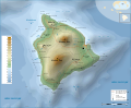
Loihi Map
-
Loihi Seamount relative to Hawaii
-
 This SVG may help.
 -
 Highlighting Loihi


Article(s): Loihi
Request: SVGify ResMar 00:28, 3 March 2009 (UTC)
Graphist opinion: Is just highlighting it on the topographic map good enough? Example added. Kmusser (talk) 22:14, 3 March 2009 (UTC)
- Looks very nice to me, but User:Resident_Mario should decide. Something went wrong with the legend in the process of translation. bamse (talk) 22:32, 3 March 2009 (UTC)
- Legend fixed. Kmusser (talk) 22:51, 3 March 2009 (UTC)
- Awesomness- MUCH better then the GIF. One thing though. At 300px (standard map infobox size), the blue triangle is hardly visible. Can you increase the size of the blue "volcano" icon and the text around it? Then you could remove the ugly red O. Hope I'm not asking too much :). Cheers, ResMar 22:06, 4 March 2009 (UTC)
- Legend fixed. Kmusser (talk) 22:51, 3 March 2009 (UTC)
New Template:Location map for locations near poles
-
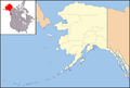 Sad, distorted map of Alaska currently in use in many infoboxes
 -
 Better map of Alaska


Article(s): Tons of Alaska infoboxes
Request: This isn't strictly a map request, though it may involve creating a map. I'm mostly posting here to get the attention of editors who might be able to do this. :) Currently the first map above is used in the infoboxes for tons of Alaska articles - all the infoboxes that use Template:Location map, which generates pushpin maps based on coordinates for infoboxes. The template uses an equirectangular projection which works well near the equator (see, e.g. Phnom Penh) but kind of sucks for locations near the poles. Is there someone clever with math who can make an equation for a non-equirectangular projection (I know basically nothing about this topic so I can't suggest a better one) to create some alternative, non-horribly-skewed map for infoboxes of places like Alaska? Thanks! And if no one here can do it do you have other ideas of where I could go to request it? I tried at requested templates but the people who hang out there don't seem very map-oriented, as I haven't got any responses yet. :( Calliopejen1 (talk) 01:33, 28 May 2009 (UTC)
Graphist opinion(s): I'm not sure where to ask either, it is a persistent problem, not just for Alaska but for all northern or southern countries as well, sadly that's beyond my programming abilities to fix. Anyone else have ideas? Seeing as the alternative is to make an individual static map for every location it would be nice to see a template/programming solution. Kmusser (talk) 13:55, 28 May 2009 (UTC)
- You should ask user STyx on WP-fr, he's our master there when the talk turns around geolocation. He already made geo-templates using conic-projected maps, and even with a Lambert azimutal equal-area one! Sting-fr (talk) 23:28, 9 June 2009 (UTC)
{{Location map skew}} or {{Location map polarx}} may be useful, but I do not see any suitable maps of Alaska to go with them. It may be possible to make something from File:National-atlas-alaska.png but what projection is it? Certes (talk) 21:46, 23 July 2009 (UTC)
Article(s): National Highway (India)
Request:Can I know how to make .png) from
File:India Highway map.svg ? That is how to crop the image(using latitude and longuitude ) and highlight the highway ?Naveenpf (talk) 17:51, 31 May 2009 (UTC)
from
File:India Highway map.svg ? That is how to crop the image(using latitude and longuitude ) and highlight the highway ?Naveenpf (talk) 17:51, 31 May 2009 (UTC)
Graphist opinion(s): This is one feature that really needs to be done, and could make detailed svg maps so much more useful. i think this should go into the technical section --59.92.35.81 -- PlaneMad|YakYak 12:42, 2 June 2009 (UTC)
New York school district map
Article(s): List of school districts in New York, plus individual school district websites
Request: Would it be possible to create an SVG map of school district boundaries in New York State? I don't have a source, but I wonder if this is possible? wadester16 16:29, 2 June 2009 (UTC)
Graphist opinion(s): I don't have time to take this on, but I do have a GIS source for anyone that does, NY GIS Clearinghouse has the district boundaries statewide. Kmusser (talk) 16:56, 2 June 2009 (UTC)
Provinces of Bulgaria
-
 Location map, useful resource IMHO

Article(s): All articles listed in Category:Provinces of Bulgaria.
Request: If it's possible, I request a SVG version for Bulgarian provinces. Thank you in advance. Regards. Rastrojo (talk) 21:47, 17 June 2009 (UTC)
Graphist opinion(s):
SVG map for Arctic
-
 SVG map of Europe
 -
 Current SVG map of Arctic
.svg)

Article(s): Arctic
Request: Following discussion at Arctic's talk page, and at WikiProject Geography, could an SVG map be made for Arctic, based on the existing SVG map used by Europe? Could blue be used for land within the "July 10°C isotherm" region, and light blue for ocean within the 10°C isotherm region? (The blues to indicate that the Arctic is a polar region, as opposed to the green used on the Europe map). Cheers, This flag once was redpropagandadeeds 11:48, 19 June 2009 (UTC)
Graphist opinion(s):
May I sugest using this map instead of the one for Europe--SelfQ (talk) 14:02, 21 June 2009 (UTC).svg)
- Heh! I wasn't very clear. Sorry! No, the map you suggested is exactly what I want - I meant to use the style of map that Europe uses, not the map itself. Sorry about that! So, the map you've suggested, with the 10 degree isotherm region marked in green and/or blue is what I'm wanting.
- Cheers, This flag once was redpropagandadeeds 16:43, 22 June 2009 (UTC)
- I'll work on this, creating one that is more centred over the North Pole, but not directly (q.v. Antarctica, at 80 or 85 degrees), and with the Prime Meridian extending downward, which is intended to convey the region's northerly nature (with south being 'down'). Bosonic dressing (talk) 19:18, 25 June 2009 (UTC)
Orthographic Map Request
With the requests above for orthographic maps, i thought I'd squeeze this request in while they are being made. Could someone make an orthographic projection of Indonesia, and fix the shadow on the below map to match the style of all others? Thanks in advance, everyone.! Connormah (talk) 18:05, 25 June 2009 (UTC)
.svg)
SVG map for the United Arab Emirates
-
 SVG map of Pakistan
 -
 Current map of the United Arab Emirates
.svg)

Article(s): United Arab Emirates
Request: Could someone please make an SVG map be made for the United Arab Emirates, based on the commons:File:Pakistan (orthographic projection).svg used by Pakistan? Thanks --MoHasanie (talk) 12:56, 27 June 2009 (UTC)
Graphist opinion:
svg font issue


Article(s): New Zealand wine
Request: Fix the fonts issue on the svg, pleeze... I've tried standard system fonts and it still won't draw properly. The one at the article is the temporary .gif I've linked to here, so you can see how it should look. The font is Helvetica Neue, 14pt & 10pt. Thanks guys. mikaultalk 02:13, 28 June 2009 (UTC)
Graphist opinion(s): It looked like a font incompatibility issue, so I changed to Helvetica and whereas the PNG versions now render ok-ish, clicking on the preview SVG reverts to Times at a set font size. --mikaultalk 08:53, 17 July 2009 (UTC)
King's Highway (Charleston to Boston)
-
 Map of the King's Highway (Charleston to Boston)
.jpg)
Article(s): King's Highway (Charleston to Boston)
Request: This very rough map was clipped from a pdf. I'd like to get a map for the article that is PD and have it loaded to the commons. See File:W-RSimpleMap.gif or File:BPR NY map.png for a similar map. Many thanks Philly jawn (talk) 03:39, 28 June 2009 (UTC)
Graphist opinion(s):
Map of Colombia
-
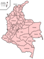 Map of Colombia

Article(s): Fútbol Profesional Colombiano, es:Torneo Apertura 2009 (Colombia)
Request: Hi, I made this requirement at Spansih Wikipedia also. I need a Colombia Locator map like those available here. Thanks a lot. ::::::100 % Bogotano:::::: (Quejas y reclamos) 17:29, 28 June 2009 (UTC)
Graphist opinion(s):
List of tallest buildings in Oklahoma City
-
 I would like something like this
Article(s): List of tallest buildings in Oklahoma City
Request: hey guys, I'm trying to get this promoted to featured list status and someone has asked for a map so people can get an idea about where the builidings are located.Showtime2009 (talk) 18:01, 29 June 2009 (UTC)
Graphist opinion:
- Do you want this file vectorized? --The New Mikemoral ♪♫ 23:01, 1 July 2009 (UTC)
- No, he wants a map of Oklahoma city (maybe from http://www.openstreetmap.org/ ?) and then put dots on the addresses marking locations in accordance with the list. This will probably be somewhat difficult to do considering we don't have good maps of most cities. gren グレン 20:48, 31 July 2009 (UTC)
File:Kernow lb.png - SVGification
-
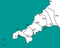 This is File:Kernow lb.png a map about the language shift of the Cornish language. It's grainy, poorly coloured, unclear and needs SVGification...
 -
 ...The colours and look of this map may be a possibe way to redesign the image?
 -
 ...Or this is another (preferable) one which is simillar and ideally would be used as the basis for a new map.
 -
 ...this is a map of Cornwall in SVG (without the Isles of Scilly and the rest of England) which could be used to speed things up?


Article(s): Cornish people, Cornish language and West Country dialects (may also be used for History of Cornwall and Anglo-Cornish dialect)
Request: A newer, sharper, clearer SVG image would be more befitting to the forthcoming, revamped version of the Cornish people article. There are other maps of Cornwall (for reference) here. The content of the map is verifiable, and is based on a page in "K. George, Cornish, in: M. Ball (ed.), (1993) The Celtic Languages".
Notice: The place names are in the Cornish language and should be in English (for the English WP). Truru should be spelt Truro, Pensans should be spelt Penzance and please ignore "Foath". --Jza84 | Talk 13:38, 3 July 2009 (UTC)
Graphist opinion(s):
Mission Control Centres
-
 World Map

Article(s): International Space Station, Mission Control Centre
Request: I was wondering if it would be possible for someone to construct a world dotmap of the locations shown on page 3 of this? It'd greatly assist in demonstrating the locations of Mission Control Centres around the globe that are involved in the International Space Station project, and would prove useful in the main MCC article. Many thanks in advance, Colds7ream (talk) 21:12, 7 July 2009 (UTC)
Graphist opinion(s):
Interracial marriage in the United States
-
 Blank US Map
 -
 Repeal by date
.svg)

Article(s): Interracial marriage in the United States
Request: First request, so sorry if I get it wrong. I'd like to request a new map showing when interracial marriage was legalised in each U.S state. The data can be found here, with the repeal of each anti-miscegenation law, the second date, being the time when interracial marriage was legalised. For Kansas, for example, interracial marriage was legalised in 1859. Suggest colour grouping by decade. Thanks, YeshuaDavid • Talk • 23:03, 12 July 2009 (UTC)
Graphist opinion: Here's my attempt: red = -1887, green = 1948-1967, blue = 12 June 1967. The colours [of a previous version] can be toned down if they are too bright. I have used the three distinct eras as in the table, because the text suggests that they are more logical groupings than decades. It can be changed to group by decade if you prefer. If so, would we then want to keep the 12 June 1967 distinction and do you have a preference for colour scheme or shall I make a logical one up? Certes (talk) 21:57, 29 July 2009 (UTC)
- I think it would be great to use colors more like the Women's Suffrage map here. They are far too bright for my tastes (and different from common usage on Wikpiedia). Great job otherwise. Thanks :) gren グレン 20:44, 31 July 2009 (UTC)
Cheers, that's really good, thanks :) I'll insert it into the article. YeshuaDavid • Talk • 00:03, 1 August 2009 (UTC)
MEGAL pipeline
Article(s): MEGAL pipeline
Request: This article is listed as 'In The News' and I think it would help if there was a map of the pipeline in the article. Various maps can be found here. All that needs to be done I suppose is redo them in a 'free' way so we can use them on wiki. Mitsuhirato (talk) 07:01, 13 July 2009 (UTC)
Graphist opinion:
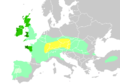
It would be best, I think, if we had a map of gas pipelines in all of Europe. In Category:Gas pipeline maps all I find is  , which might do for the MEGAL if the lines would have been labeled. Advantage of a pan-European map would be that it could also be used for all other pipelines, e.g. Trans Europa Naturgas Pipeline. Such a map would look like this, maybe. My suggestions:
- Have different widths to signify double or triple pipelines (makes it less cluttered)
- Clearly indicate direction of flow, which is fixed (distinguishes North Sea gas from Russian and Algerian gas).
If anybody wants to take this up, feel free; otherwise, I might have a go at it myself. Classical geographer (talk) 17:25, 14 July 2009 (UTC)
- By the way, other nice maps are this map of Germany and this map of the Ukraine. Not that these need to be included in full in any European map; but they might be helpful. I'll also make a quick locator map straight away, that can be used temporarily. Classical geographer (talk) 17:27, 14 July 2009 (UTC)
- Here's the simple map:
 . Classical geographer (talk) 21:11, 14 July 2009 (UTC)
- Here's the simple map:

Thanks! I think your idea of a map of all the pipelines is a great idea too. Mitsuhirato (talk) 02:39, 15 July 2009 (UTC)
Marco Polo's Journey
-
Description of image
Article(s):
- Marco Polo a WP:Vital and about 40 other languages
- The Travels of Marco Polo
- Niccolò and Maffeo Polo
- and many other languages
Request: -- Diaa abdelmoneim (talk) 12:21, 6 July 2009 (UTC) After waiting some time at the Graphics school I found out about this project. We're working on Wikipedia:Spotlight on Marco Polo. Marco Polo is a very prominent explorer and his article is visited by thousands every day. We currently have the one above which is very bad considering general route maps we have. Could someone create an svg route map of his journey, which could later contain the names he gave to the cities he stopped in and so on? Possible references would be
- I would also appreciate work on this subject. Thanks in advance! LouriePieterse (talk) 16:10, 14 July 2009 (UTC)
Graphist opinion:
Road map for Utah State Route 143
Article(s): Utah State Route 143
Request: Could I get a basic road map created for this state route? I imagine that GIS data has been used in the other Utah state route maps, but I'm not particularly knowledgeable about that stuff. DeFaultRyan 21:39, 16 July 2009 (UTC)
Graphist opinion(s):
Caspian Airlines Flight 7908' route
Here is the link to a approximate route of the Caspian Airlines Flight 7908
Article(s): Caspian Airlines Flight 7908 Request: Please create a version of it for use on wikipeida. yousaf465' 16:56, 17 July 2009 (UTC) Graphist opinion: I'm not sure this is worth the effort, as it's a one-off event, and besides, such a map would not show much more than dots for origin and destination, and an intrapolated route (possibly following a great circle). Classical geographer (talk) 10:59, 20 July 2009 (UTC)
Dot map for Minto, Alaska
-
Sample dot map
Article(s): Minto, Alaska
Request: If someone has a moment, could they please create a dot map for Minto, Alaska? Right now, it's using the dot map for Nenana, Alaska, which is some 100 miles to the southeast. JKBrooks85 (talk) 10:32, 23 July 2009 (UTC)
Graphist opinion(s): I have replaced the map by a pushpin map. This is simply an edit to the infobox: no new images uploaded. Is that good enough? If not, please revert my change to Minto, Alaska. Certes (talk) 15:30, 23 July 2009 (UTC)
- I guess it works, but I'll echo the comment made by someone above ... the pushpin maps don't really work for Alaska locations because the map is so badly distorted. JKBrooks85 (talk) 20:10, 23 July 2009 (UTC)
- Good point. Please can someone else either produce a quick PNG or make a better-looking location map on a projection suitable for use with {{Location map skew}} or {{Location map polarx}}? File:National-atlas-alaska.png or File:Arctic.svg (cropped and rotated) may be helpful. Certes (talk) 21:52, 23 July 2009 (UTC)
Far East Council

Article(s): American Scouting overseas
Request: not chopped up, same perspective so a single map instead of three, thanks... Chris (クリス • フィッチュ) (talk) 12:36, 23 July 2009 (UTC)
Graphist opinion:
map of cologne electorate? 16th century
-
 old map of Electorate of Cologne

Article(s): Cologne War
Request: Need a map of the electorate of Cologne. I've tweaked an old map above but I am unskilled at these things. It needs a professional, and would benefit from someone who could make a map that would take out a lot of the details of this old map, and leave in some specific details. I can help, but I cannot do the graphics parts. Even a general map showing the boundaries and neighboring states would help, since the concept of "electorate" was different in 1585 than it is now. Auntieruth55 (talk) 20:04, 27 July 2009 (UTC)
Graphist opinion(s):
Canadian Election Maps
-
 2006 Canadian Federal Election
 -
 2nd image (If there is one)
 -
2004 Canadian Federal Election
-
2000 Canadian Federal Election
-
1997 Canadian Federal ELection


-
 Base off this file
 -
 Base off this file


Article(s): 2006 Canadian Federal Election, 2004 Canadian Federal Election...etc.
Request: Please make SVGs of the PNGs listed above using the SVG files for a template thst I have provided above. Thanks. Connormah (talk) 00:18, 2 June 2009 (UTC)
Graphist opinion(s):