
Bhangel: Difference between revisions
m secreatry->secretary - Fix a typo in one click |
m Normalize {{Multiple issues}}: Remove {{Multiple issues}} for only 1 maintenance template(s): Unreferenced |
||
| Line 1: | Line 1: | ||
{{Orphan|date=April 2017}} |
|||
{{unreferenced|date=February 2018 |
{{unreferenced|date=February 2018}} |
||
{{Use dmy dates|date=March 2015}} |
{{Use dmy dates|date=March 2015}} |
||
Revision as of 16:25, 31 May 2020
Bhangel | |
|---|---|
| Nickname: Bhangel | |
 Bhangel Location in Uttar Pradesh, India | |
| Coordinates: 28°32′N 77°23′E / 28.54°N 77.38°E | |
| Country | |
| State | Uttar Pradesh |
| District | Gautambudh Nagar |
| Government | |
| • Type | Nagar Panchayat |
| Elevation | 92 m (302 ft) |
| Population (2014) | |
| • Total | 175,890 (Approx) |
| Languages Hindi & Hariyanwi A local version of Hindi, Shri Ramcharit Manas was written by Tulasidas in Awadhi. | |
| • Official | Hindi |
| Time zone | UTC+5:30 (IST) |
| 201304 PIN | [201304] |
| Telephone code | 0120 |
| Vehicle registration | UP 16 |
| Sex ratio | 860 ♂/♀ |
Bhangel is a small semi-urban neighborhood in Noida, in Gautam Buddh Nagar district of the Indian state of Uttar Pradesh.
History
Earlier called Begumpur, Bhangel is a well-known locality close to Noida Special Economic Zone. Presently, it is one of the most populated neighborhoods in the Noida region. The high population density of this locality is attributed to its proximity to several industrial hubs in Noida. People from all over the country, particularly the working class, live here.
-
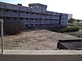 The back of the CBSE-affiliated school called, Noida Educational Academy.
 -
 A alley in Goyal Colony, Bhangel, Noida


Administration & Connectivity
The town is governed under the village assembly rules and regulations of the Indian Government. However, the municipal corporation, as well as the pertinent administrative authority, is also responsible for the maintenance of Bhangel, similar to other cities. It falls in the district of Gautam Budh Nagar and is well connected to the other nearby cities like Delhi, Greater Noida, Ghaziabad, and Gurgaon by Dadri Main Road. It has one bus station and the nearest metro station is NSEZ metro station with the 2nd second nearest one being Noida Sector 81 metro station. The locality is well connected to Noida Expressway, which makes traveling to the capital city of Delhi easy.
Geography & Demographics
The entire neighborhood spans over an area of around 5 square kilometers. While there is no official record of the population of Bhangel, it is estimated to be somewhere between 0.2-0.3 million. The people living here are known to settle down here from different parts of the country, specifically from other parts of Uttar Pradesh and the neighboring states of Punjab, Haryana, Delhi, Rajasthan, and Uttarakahand. The majority of the population here belong to the Hindu Tyagi Brahmin and Gurjar community . There is also a decent population of Muslims residing in this locality.
Infrastructural Amenities
The town has all necessary infrastructural facilities, including public and private sector banks, hospitals, schools, restaurants, retail shops, and a police station. The Dadri Main Road, which traverses right across the heart of Bhangel is well connected to SEZ Noida, Noida Phase-II Industrial Area, Surajpur, and further to Dadri and Greater Noida. M.C.D. Primary he community School t, Little Flock Mission School, and Noida Educational Academy. The social activist & BJP leader Vinod Tyagi is well known among the community. Tyagi worked over many positions including District Secreatry and currently working as the secretary of the western up. There is one Public Health Center in Noida Sector-110, near Bhangel Community Center. Besides, Bhangel Main Market on Bhangel-Gejha Road, the neighborhood has the supermarket outlet, Vishal Mega Mart. A few mosques and Hindu temples also exist in this area.