Cranendonck: Difference between revisions
Appearance
Content deleted Content added
m Bot: fix deprecated Citation Style 1 parameters (Task 9) |
Rescuing 1 sources and tagging 0 as dead. #IABot (v1.6.1) (Balon Greyjoy) |
||
| Line 33: | Line 33: | ||
|publisher = [[Statistics Netherlands|CBS]] |
|publisher = [[Statistics Netherlands|CBS]] |
||
|accessdate = 8 May 2014}}</ref> |
|accessdate = 8 May 2014}}</ref> |
||
| government_footnotes = <ref name="mayor_now">{{cite web |
| government_footnotes = <ref name="mayor_now">{{cite web |
||
|url = http://www.cranendonck.nl/bestuur-en-organisatie/wie-is-wie_3269/ |
|url = http://www.cranendonck.nl/bestuur-en-organisatie/wie-is-wie_3269/ |
||
|title = Wie is wie |
|title = Wie is wie |
||
|trans-title=Who is who |
|trans-title = Who is who |
||
|language = Dutch |
|language = Dutch |
||
|author = |
|author = |
||
|date = |
|date = |
||
|work = |
|work = |
||
|publisher = Gemeente Cranendonck |
|publisher = Gemeente Cranendonck |
||
|accessdate = 8 May 2014 |
|accessdate = 8 May 2014 |
||
|deadurl = yes |
|||
|archiveurl = https://web.archive.org/web/20140425084138/http://www.cranendonck.nl/bestuur-en-organisatie/wie-is-wie_3269/ |
|||
|archivedate = 25 April 2014 |
|||
|df = |
|||
}}</ref> |
|||
| governing_body = [[Municipal council (Netherlands)|Municipal council]] |
| governing_body = [[Municipal council (Netherlands)|Municipal council]] |
||
| leader_party = [[Christian Democratic Appeal|CDA]] |
| leader_party = [[Christian Democratic Appeal|CDA]] |
||
Revision as of 03:49, 28 November 2017
Cranendonck | |
|---|---|
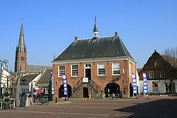
 Former city hall of Budel | |
 Location in North Brabant | |
| Coordinates: 51°18′N 5°35′E / 51.300°N 5.583°E | |
| Country | Netherlands |
| Province | North Brabant |
| Established | 1 January 1997[1] |
| Government | |
| • Body | Municipal council |
| • Mayor | Marga Vermue-Vermue (CDA) |
| Area | |
| • Total | 78.05 km2 (30.14 sq mi) |
| • Land | 76.40 km2 (29.50 sq mi) |
| • Water | 1.65 km2 (0.64 sq mi) |
| Elevation | 28 m (92 ft) |
| Population (January 2021)[5] | |
| • Total | 21,001 |
| • Density | 275/km2 (710/sq mi) |
| Time zone | UTC+1 (CET) |
| • Summer (DST) | UTC+2 (CEST) |
| Postcode | 6020–6028 |
| Area code | 0495 |
| Website | www |
Cranendonck () is a municipality in the southern Netherlands. Though located in North Brabant near Eindhoven, the spoken dialect is Budels (linguistically a Limburgish dialect), rather than Kempenlands (linguistically an East Brabantian dialect).
Population centres
Topography
Dutch topographic map of the municipality of Cranendonck, June 2015
References
- ^ "Gemeentelijke indeling op 1 januari 1997" [Municipal divisions on 1 January 1997]. cbs.nl (in Dutch). CBS. Retrieved 8 May 2014.
- ^ "Wie is wie" [Who is who] (in Dutch). Gemeente Cranendonck. Archived from the original on 25 April 2014. Retrieved 8 May 2014.
{{cite web}}: Unknown parameter|deadurl=ignored (|url-status=suggested) (help) - ^ "Kerncijfers wijken en buurten 2020" [Key figures for neighbourhoods 2020]. StatLine (in Dutch). CBS. 24 July 2020. Retrieved 19 September 2020.
- ^ "Postcodetool for 6027RK". Actueel Hoogtebestand Nederland (in Dutch). Het Waterschapshuis. Retrieved 8 May 2014.
- ^ "Bevolkingsontwikkeling; regio per maand" [Population growth; regions per month]. CBS Statline (in Dutch). CBS. 1 January 2021. Retrieved 2 January 2022.
External links
 Media related to Cranendonck at Wikimedia Commons
- Official website


