
Fort Coenraadsburg: Difference between revisions
Content deleted Content added
No edit summary |
Added first sources |
||
| Line 1: | Line 1: | ||
{{unreferenced|date=March 2015}} |
|||
{{Infobox military structure |
{{Infobox military structure |
||
|name = Fort Coenraadsburg |
|name = Fort Coenraadsburg |
||
| Line 6: | Line 5: | ||
|location = |
|location = |
||
|image = [[File:St Jago.JPG|250px]] |
|image = [[File:St Jago.JPG|250px]] |
||
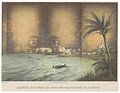
|caption = 17th |
|caption = 17th century view on Elmina. Fort Elmina is on the left, Fort Coenraadsburg on the right. |
||
|map_type = Ghana |
|map_type = Ghana |
||
|map_size = |
|map_size = |
||
| Line 34: | Line 33: | ||
|footnotes={{Infobox World Heritage Site|child=yes}} |
|footnotes={{Infobox World Heritage Site|child=yes}} |
||
}} |
}} |
||
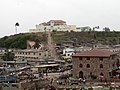
'''Fort Coenraadsburg''' or '''Conraadsburg''', also '''Fort São Tiago da Mina''', is a fort on the [[Dutch Gold Coast]], built in 1652 to protect [[Fort Elmina]] from attacks. It was built on the site of a fortified chapel that the Portuguese had built and that the Dutch had burned to the ground in the [[Battle of Elmina (1637)]]. The Dutch ceded the fort to Britain in 1872, together with the entire Dutch Gold Coast. |
'''Fort Coenraadsburg''' or '''Conraadsburg''', also '''Fort São Tiago da Mina''', is a fort on the [[Dutch Gold Coast]], built in 1652<ref name=":0">{{Cite book|url=https://books.google.co.uk/books?id=8hMOAQAAMAAJ&q=Fort+Coenraadsburg+1652&dq=Fort+Coenraadsburg+1652&hl=en&sa=X&ved=0ahUKEwiG9LmBl8bVAhUsKsAKHc3IA98Q6AEIKDAA|title=Transactions of the Historical Society of Ghana|last=|first=|date=1959|publisher=The Society|year=|isbn=|location=|pages=61|language=en}}</ref> to protect [[Fort Elmina]] from attacks. It was built on the site of a fortified chapel that the Portuguese had built<ref name=":0" /> and that the Dutch had burned to the ground in the [[Battle of Elmina (1637)]]. The Dutch ceded the fort to Britain in 1872, together with the entire Dutch Gold Coast.<ref>{{Cite book|url=https://books.google.co.uk/books?id=z8OwCQAAQBAJ&pg=PA246&dq=dutch+gold+coast+britain+1872&hl=en&sa=X&ved=0ahUKEwjjrJe3l8bVAhWLA8AKHTlJBZYQ6AEIMjAC#v=onepage&q=dutch%20gold%20coast%20britain%201872&f=false|title=Sources for the Mutual History of Ghana and the Netherlands: An annotated guide to the Dutch archives relating to Ghana and West Africa in the Nationaal Archief 1593-1960|last=Doortmont|first=|last2=Smit|first2=Jinna|date=2007-09-21|publisher=BRILL|year=|isbn=9789047421894|location=|pages=246|language=en}}</ref> |
||
==Gallery== |
==Gallery== |
||
Revision as of 22:36, 7 August 2017
| Fort Coenraadsburg | |
|---|---|
| Part of Dutch Gold Coast | |
 17th century view on Elmina. Fort Elmina is on the left, Fort Coenraadsburg on the right. | |
 Fort Coenraadsburg | |
| Coordinates | 5°05′04″N 1°21′03″W / 5.08444°N 1.35083°W |
| Site history | |
| Built | 1652 |
| Garrison information | |
| Occupants | Netherlands (1652-1872) |
Fort Coenraadsburg or Conraadsburg, also Fort São Tiago da Mina, is a fort on the Dutch Gold Coast, built in 1652[1] to protect Fort Elmina from attacks. It was built on the site of a fortified chapel that the Portuguese had built[1] and that the Dutch had burned to the ground in the Battle of Elmina (1637). The Dutch ceded the fort to Britain in 1872, together with the entire Dutch Gold Coast.[2]
Gallery
-
 Fort Coenraadsburg (published 1861)
 -
 View of Coenraadsburg from Elmina
 -
 Fort Coenraadsburg
_p113_KASTEEL_ST.GEORGE_EN_FORT_COENRAADSBURG_TE_ELMINA.jpg)


References
- ^ a b Transactions of the Historical Society of Ghana. The Society. 1959. p. 61.
- ^ Doortmont; Smit, Jinna (2007-09-21). Sources for the Mutual History of Ghana and the Netherlands: An annotated guide to the Dutch archives relating to Ghana and West Africa in the Nationaal Archief 1593-1960. BRILL. p. 246. ISBN 9789047421894.