
Canon Pyon: Difference between revisions
m Bot: Migrating 1 interwiki links, now provided by Wikidata on d:q3783975 |
No edit summary |
||
| Line 1: | Line 1: | ||
{{unreferenced|date=March 2011}} |
{{unreferenced|date=March 2011}} |
||
| ⚫ | |||
'''Canon Pyon''' is a village on the [[A4110 road]] in [[Herefordshire]], England. |
'''Canon Pyon''' is a village and [[civil parish]] on the [[A4110 road]] in [[Herefordshire]], England. |
||
The name derives from the nearby Pyon Hill. 'Pyon', is unusual and is not used anywhere else in Britain, with the exception of the nearby village of Kings Pyon, on the other side of the hill. |
The name derives from the nearby Pyon Hill. 'Pyon', is unusual and is not used anywhere else in Britain, with the exception of the nearby village of Kings Pyon, on the other side of the hill. The civil parish includes [[Kings Pyon]], [[Westhope, Herefordshire|Westhope]] and [[Ledgemoor]]. Canon Pyon, along with the other three parishes has a magazine, The Pyonear. |
||
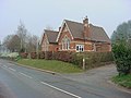
The 13th-century church of St Lawrence is a grade I listed building. <ref> {{cite web| url = http://www.britishlistedbuildings.co.uk/en-149686-church-of-st-lawrence-canon-pyon-| title = Church of St Lawrence, Canon Pyon| publisher= British Listed Buildings|accessdate = 29 January 2014}} </ref> Local amenities include a; village shop, Canon Pyon Stores; pub, The Nag's Head; village hall; parish church; and [http://canonpyon.hmfa.org.uk Canon Pyon CE Primary School]. |
|||
Canon Pyon shares a parish council with [[Kings Pyon]], [[Westhope, Herefordshire|Westhope]] and [[Ledgemoor]]. |
|||
Canon Pyon, along with the other three parishes has a magazine, The Pyonear. |
|||
Local amenities include a; village shop, Canon Pyon Stores; pub, The Nag's Head; village hall; parish church; and [http://canonpyon.hmfa.org.uk Canon Pyon CE Primary School]. |
|||
<gallery perrow="4"> |
<gallery perrow="4"> |
||
File:Canon Pyon |
File:Canon Pyon Church - geograph.org.uk - 469980.jpg|St Lawrence's church |
||
File:Canon Pyon |
File:Canon Pyon Stores.jpg|Canon Pyon Stores |
||
| ⚫ | |||
File:Canon Pyon Village Hall .jpg|Canon Pyon Village Hall |
File:Canon Pyon Village Hall .jpg|Canon Pyon Village Hall |
||
File:Canon Pyon Primary School - geograph.org.uk - 380375.jpg|Canon Pyon CE Primary School |
File:Canon Pyon Primary School - geograph.org.uk - 380375.jpg|Canon Pyon CE Primary School |
||
| ⚫ | |||
| ⚫ | |||
File:Pyonear.jpg|The Pyonear |
File:Pyonear.jpg|The Pyonear |
||
</gallery> |
</gallery> |
||
==References== |
|||
{{reflist}} |
|||
{{Herefordshire}} |
|||
{{coord|52.135|-2.786|display=title}} |
{{coord|52.135|-2.786|display=title}} |
||
Revision as of 17:06, 29 January 2014

Canon Pyon is a village and civil parish on the A4110 road in Herefordshire, England.
The name derives from the nearby Pyon Hill. 'Pyon', is unusual and is not used anywhere else in Britain, with the exception of the nearby village of Kings Pyon, on the other side of the hill. The civil parish includes Kings Pyon, Westhope and Ledgemoor. Canon Pyon, along with the other three parishes has a magazine, The Pyonear.
The 13th-century church of St Lawrence is a grade I listed building. [1] Local amenities include a; village shop, Canon Pyon Stores; pub, The Nag's Head; village hall; parish church; and Canon Pyon CE Primary School.
-
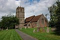 St Lawrence's church
 -
 Canon Pyon Stores
 -
 The Nag's Head
 -
 Canon Pyon Village Hall
 -
 Canon Pyon CE Primary School
 -
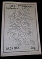 The Pyonear


References
- ^ "Church of St Lawrence, Canon Pyon". British Listed Buildings. Retrieved 29 January 2014.
52°08′06″N 2°47′10″W / 52.135°N 2.786°W
This Herefordshire location article is a stub. You can help Wikipedia by expanding it. |