
Halifax Public Gardens: Difference between revisions
Hantsheroes (talk | contribs) |
Hantsheroes (talk | contribs) No edit summary |
||
| Line 25: | Line 25: | ||
The Public Gardens were badly damaged by [[Hurricane Juan]] in 2003. Many trees were destroyed, necessitating the early closure of the gardens and some redesign. The gardens reopened on [[Canada Day]], 2004 after a restoration aided in part by $1 million which was raised during a radio telethon. |
The Public Gardens were badly damaged by [[Hurricane Juan]] in 2003. Many trees were destroyed, necessitating the early closure of the gardens and some redesign. The gardens reopened on [[Canada Day]], 2004 after a restoration aided in part by $1 million which was raised during a radio telethon. |
||
== History == |
|||
The Halifax Public Gardens was established in 1874 by the amalgamation of two older gardens, the Nova Scotia Horticultural Society Garden (laid out in 1837) and an adjacent public park (opened in 1866). In 1872, Robert Power was hired as the park’s superintendent. He introduced an axially symmetrical plan which governs the overall design of the site. Over the years, he oversaw the introduction of the bandstand (designed by architect Henry Busch), fountains, statues, and wrought iron gates as well as establishing the bedding out of annuals in highly designed carpet beds, redesigned Griffin’s Pond and introduced water fowl.<ref>http://www.halifax.ca/publicgardens/documents/2009_VictoriaJubileeFountain-CulturalAssetStudy.pdf</ref> |
|||
== Monuments and Commemorations== |
== Monuments and Commemorations== |
||
Revision as of 22:57, 17 July 2012
| Halifax Public Gardens | |
|---|---|
 Entrance to the Public Gardens in Halifax | |
 | |
| Type | Public park |
| Location | Halifax, Nova Scotia |
| Area | 16 Acres |
| Created | 1867 |
| Operated by | Halifax Regional Municipality |

The Halifax Public Gardens are Victorian era public gardens formally established in 1867, the year of Canadian Confederation. The gardens are located in the Halifax Regional Municipality, Nova Scotia on the Halifax Peninsula near the popular shopping district of Spring Garden Road and opposite Victoria Park. The gardens were designated as a national historic site in 1984.
Gardens

The Public Gardens encompass 16 acres and are bounded by Spring Garden Road, South Park Street, Summer Street and Sackville Street. They are open annually from approximately May 1 until November 1. The landscaping style is Victorian formal and provides a popular setting for wedding and prom photos. In addition to statues and extensive flower beds, there are three fountains, two stone bridges, three ponds (one large and two small), and a small concession building (located in the original Horticultural Hall).[1] The gardens also feature a bandstand that is used for free public concerts on Sunday afternoons during the summer. There are celebrations in the gardens every year on Canada day (July 1st) and Natal Day (the first Monday in August).
In the past, many people enjoyed feeding the ducks who make the gardens their home, although it is now prohibited.[2]
The Public Gardens were badly damaged by Hurricane Juan in 2003. Many trees were destroyed, necessitating the early closure of the gardens and some redesign. The gardens reopened on Canada Day, 2004 after a restoration aided in part by $1 million which was raised during a radio telethon.
History
The Halifax Public Gardens was established in 1874 by the amalgamation of two older gardens, the Nova Scotia Horticultural Society Garden (laid out in 1837) and an adjacent public park (opened in 1866). In 1872, Robert Power was hired as the park’s superintendent. He introduced an axially symmetrical plan which governs the overall design of the site. Over the years, he oversaw the introduction of the bandstand (designed by architect Henry Busch), fountains, statues, and wrought iron gates as well as establishing the bedding out of annuals in highly designed carpet beds, redesigned Griffin’s Pond and introduced water fowl.[3]
Monuments and Commemorations
-
 Francis Joseph Fitzgerald Bridge (1911)
 -
 Francis Fitzgerald Bridge Plaque
 -
 Halifax Provisional Battalion Plaque, Main Gate (1907)
 -
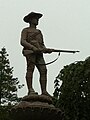 Boer War Sculpture by renowned sculptor Hamilton MacCarthy (1903)
 -
 John Bartholomew Gough Plaque (1936)


The Public Gardens has various war monuments. There is a commemorative plaque for the Halifax Provisional Battalion (1785) which served in the North West Rebellion.
There is also a statue of a soldier from the Canadian Mounted Rifles (renamed the Royal Canadian Dragoons)[4] who fought in the Second Boer War by renowned sculptor Hamilton MacCarthy. [5] A tree was also planted in memory of the first Canadian casualty of the Boer War, Charles Carroll Wood.
There is also a bridge that commemorates Nova Scotian Francis Joseph Fitzgerald of the Royal Northwest Mounted Police who died tragically in the "Lost Patrol".[6]
Another tree was planted and plaque created for renowned temperance crusader John Bartholomew Gough by the Rosebud Band of Hope and the Sons of Temperance (1936). Gough wrote about visiting Halifax:
- I continued there for more than a week, delivering nine lectures. I had an opportunity of addressing the famous 42nd Regiment of Foot, then stationed at Halifax. An English paper stated, three years after, that "many of the men were all the better for it."[7]
Further reading
- The Halifax Public Gardens, The Friends of the Public Gardens, Halifax, 1989
- "The Magnolia Tree", a short story by Barbara Grantmyre published in Atlantic Anthology, Will R. Bird, ed., McLelland & Stewart, 1959.
External links
- Friends of the Halifax Public Gardens
- Photographs from Images Canada (historic and contemporary)
- Halifax Public Gardens Protection Act
- Canadian Biography Online - Francis Fitzgerald
References
- ^ Friends of the Public Gardens website
- ^ Halifax Public Gardens a no-feeding zone for Ducks
- ^ http://www.halifax.ca/publicgardens/documents/2009_VictoriaJubileeFountain-CulturalAssetStudy.pdf
- ^ Canadian Mounted Rifles
- ^ Carman Miller. Painting the Map Red: Canada and the South African War, 1899-1902. McGill-Queen's University Press. 1998. p. 435. Note: Local veteran of the Boer War William Pickering of the 4th Regiment Canadian Mounted Rifles served as the model for the sculpture. His regiment never saw action on the frontline.
- ^ Canadian Biography Online - Francis Fitzgerald. Also see http://canada.odmp.org/officer/352-inspector-francis-joseph-fitzgerald As well as Dick North. The Lost Patrol. Anchorage: Alaska Northwest Books, 1978, reprinted 1990, 1995.
- ^ AUTOBIOGRAPHY Of JOHN B. GOUGH. p. 272-3
44°38′34″N 63°34′56″W / 44.64278°N 63.58222°W
This Halifax County, Nova Scotia location article is a stub. You can help Wikipedia by expanding it. |