
Greenwood–Leflore Airport: Difference between revisions
→External links: added categories |
→References: added references |
||
| Line 74: | Line 74: | ||
== References == |
== References == |
||
{{portal|United States Air Force|Seal of the US Air Force.svg}} |
|||
| ⚫ | |||
{{portalpar|Military of the United States|Flag of the United States.svg|65}} |
|||
{{AFHRA}} |
{{AFHRA}} |
||
{{reflist}} |
|||
| ⚫ | |||
* Shaw, Frederick J. (2004), Locating Air Force Base Sites History’s Legacy, Air Force History and Museums Program, United States Air Force, Washington DC, 2004. |
|||
| ⚫ | |||
| ⚫ | |||
== External links == |
== External links == |
||
Revision as of 18:18, 24 February 2010
Greenwood-Leflore Airport | |||||||||||||||||||
|---|---|---|---|---|---|---|---|---|---|---|---|---|---|---|---|---|---|---|---|
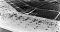
 USGS aerial photo - 17 Feb 1996 | |||||||||||||||||||
| Summary | |||||||||||||||||||
| Airport type | Public | ||||||||||||||||||
| Owner | Greenwood City & Leflore County | ||||||||||||||||||
| Serves | Greenwood, Mississippi | ||||||||||||||||||
| Location | Carroll County, Mississippi | ||||||||||||||||||
| Elevation AMSL | 162 ft / 49 m | ||||||||||||||||||
| Coordinates | 33°29′40″N 090°05′05″W / 33.49444°N 90.08472°W | ||||||||||||||||||
| Website | www.GWOairport.com | ||||||||||||||||||
| Runways | |||||||||||||||||||
| |||||||||||||||||||
| Statistics (2007) | |||||||||||||||||||
| |||||||||||||||||||
Greenwood-Leflore Airport (IATA: GWO, ICAO: KGWO, FAA LID: GWO) is a public use airport located six nautical miles (11 km) east of the central business district of Greenwood, the county seat of Leflore County, Mississippi, United States. The airport is owned by the City of Greenwood and Leflore County, but is actually located within located in Carroll County.[1] It serves the general aviation community, with no scheduled commercial airline service.
History
Greenwood Airport was built by the United States Army Air Forces as a basic flight training airfield. Greenwood Army Airfield was the home of the 7th Basic Flying Training Group (BFT), and assigned to the Eastern Flying Training Command.
As originally constructed the base had four 5,000-foot X 150-foot runways and a 50-acre concrete parking apron. The pavement required was the equivalent of 65 miles of two-lane highway. In addition, there were rail lines which were used to deliver gasoline and oil as well as coal and freight. On occasion, a troop train would venture onto the base to deliver or pick up cadets. There were 375 buildings, including; three fire stations, a 170-bed hospital, theater, chapel, recreation halls, post exchanges, mess halls, warehouses, barracks, a photo lab, parachute building, hangars, a sub depot, link trainer buildings, ground schools, a large swimming pool and myriad of other buildings necessary to run a ‘small city.’
Because of a severe housing shortage, the Army later added several hundred apartment units known as Greenaire Homes. They were home for many enlisted men and their dependents as well as civilian workers.
Greenwood AAF was also home to a contingent of Women's Army Service Pilots (WASPs). These women were rated to fly everything from B-24s to fighters. During the peak of basic training activities, the airfield averaged about 36,000 operations per month and the aircraft consumed millions of gallons of aviation gasoline annually.
The original mission of Greenwood Army Air Field (GAAF) was Basic Flight Training and the base was home to several hundred Consolidated Vultee BT-13 and BT-15 Valiants. The BT's trained thousands of fledgling military aviators. As basic training evolved, various twin-engine trainers such as the Cessna AT-17 and AT-8, and the Beechcraft AT-10 Wichita were brought into the inventory in an effort to make the transition to advanced twin-engine schools easier. This idea never fully developed and the aircraft were stored in serviceable condition. The field also had the usual complement of Noorduyn Norseman UC-64s, Cessna UC-78s and C-45 Expeditors.
On 18 December 1944, the Eastern Flying Training Command turned the field over to the Air Transport Command's 4th Operational Training Unit (OTU). The 590th Army Air Force Base Unit was reassigned to Greenwood AAF from Brownsville Army Airfield Texas. The arrival of the 4th OTU brought two new missions to GAAF. The BTs were replaced with AT-6 Texans and scores of fighters, including the P-51, P-47, P-38 and P-63, which were used for fighter transition training. A C-47 instrument school was also introduced and more than 20 C-47s were based at the field. Other aircraft assigned to GAAF included a B-17E Flying Fortress, several B-25 Mitchells and an L-5 Sentinel. The Air Transport Command operated the airfield until flight training ceased in late 1945 and the base was place in caretaker status until being turned over to the city of Greenwood by the War Assets Administration. As late as 1948, the Army and War Assets Administration maintained a fire station and a small contingent to look after the dormant air base.
For the next 21 years, the base was abandoned and most of the wartime buildings disappeared. In 1967, the city of Greenwood made a decision to relocate the Greenwood Municipal Airport to the abandoned Army Air Field. Runway 5/23 was lighted and placed in use. Weeds were removed from the miles of expansion joints on the otherwise intact ramp and a new rotating beacon was installed. At that time, only sixteen of the wartime structures included the old sub depot remained. At the time the airport was relocated, a new FAA Flight Service Station was constructed. Eventually, runway 18/36 was repaired and outfitted with new high-intensity runway lighting and an Instrument Landing System with MALSR. In 1989 a control tower was commissioned, and in the early 1990s runway 18/36 was lengthened to 6,503' and strengthened to accommodate wide-body aircraft.
Today, the Greenwood-Leflore Airport conducts more than 45,000 flight operations annually and is host to more than 70 single and multi-engine aircraft, business jets and helicopters.
-
 27 July 1944 aerial view of tornado damage at GAAF
 -
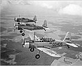 Flight of BT-13s
 -
 4th OTU airshow celebrating the fourth anniversary of the Air Transport Command in June of 1945
 -
 1943 view looking east from the GAAF control tower toward the PLM and Squadron Hangars


Facilities and aircraft
Greenwood-Leflore Airport covers an area of 816 acres (330 ha) at an elevation of 162 feet (49 m) above mean sea level. It has three asphalt paved runways: 18/36 is 6503 by 150 feet (1982 x 46 m), 5/23 is 5005 by 150 feet (1526 x 46 m) and 9/27 is 2689 by 60 feet (820 x 18 m).[1]
For the 12-month period ending November 28, 2007, the airport had 42,116 aircraft operations, an average of 115 per day: 87% general aviation, 10% military and 3% air taxi. At that time there were 68 aircraft based at this airport: 57% single-engine, 15% multi-engine, 4% jet, 16% helicopter, 7% glider.[1]
See also
References
![]() This article incorporates public domain material from the Air Force Historical Research Agency
This article incorporates public domain material from the Air Force Historical Research Agency
- Shaw, Frederick J. (2004), Locating Air Force Base Sites History’s Legacy, Air Force History and Museums Program, United States Air Force, Washington DC, 2004.
- Manning, Thomas A. (2005), History of Air Education and Training Command, 1942–2002. Office of History and Research, Headquarters, AETC, Randolph AFB, Texas ASIN: B000NYX3PC
External links
- Greenwood-Leflore Airport, official site
- FAA Terminal Procedures for GWO, effective May 16, 2024
- Resources for this airport:
- FAA airport information for GWO
- AirNav airport information for KGWO
- ASN accident history for GWO
- FlightAware airport information and live flight tracker
- NOAA/NWS weather observations: current, past three days
- SkyVector aeronautical chart, Terminal Procedures
| Flying training |
|  | ||||
|---|---|---|---|---|---|---|
| Technical training | ||||||