Lae Airfield: Difference between revisions
added military infobox |
→History: edietd and expanded |
||
| Line 34: | Line 34: | ||
==History== |
==History== |
||
Built in the 1930s the airport was known as Lae Drome or Lae Aerodrome. The largest aircraft to use the airport prewar were Junkers G.31 Tri-Motor. that serviced the gold fields at Bulolo. The problem with Lae's east/west runway was that it ran directly into hills, limiting the size of aircraft able to land. |
|||
This airfield is probably most famous for its pre war distinction as being the place where [[Amelia Earhart]]'s Lockheed Model 10 Electra took off before disappearing on her around the world flight. It was the last stop she made before going missing, to this day her plane has never been found. There is a small Amelia Earhart plaque at the former airport. |
|||
Occupied by the Japanese in February 1942 and developed into a forward airbase. The airfield was heavily bombed by Allied forces until its liberation. |
|||
After the September 1943 liberation of the Lae area, the airfield was occupied by the Allies, they used the airfield for smaller aircraft, with the larger types flying to Nadzab Airfield, the main American base in the area. |
|||
Post war, the airfield continued to be used. The largest passenger aircraft to use Lae was Lockheed's turboprop Electra. The strip was abandoned in the 1980s, in favor of Nadzab Airfield, which is able to accommodate larger jet aircraft. The former runway still remains, but is slowly being built over, a road now runs across the center of the old runway. |
|||
==See also== |
==See also== |
||
Revision as of 14:45, 13 January 2009
| Lae Airfield | |
|---|---|
| Part of Fifth Air Force | |
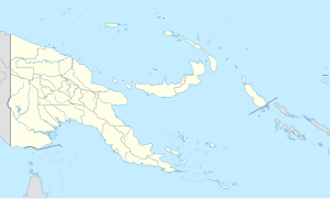
| Located in Oro Province, Paupa New Guinea | |
| Coordinates | 06°43′59.58″S 146°59′44.90″E / 6.7332167°S 146.9958056°E |
| Type | Military Airfield |
| Site information | |
| Controlled by | United States Army Air Forces |
| Site history | |
| Built | 1930s (prewar airport) |
| In use | 1942-1945 |
- for the Civilian Airport in Papua New Guinea see Lae Nadzab Airport
Lae Airfield is a former World War II airfield and later, civilian airport in Morobe Province, Papua New Guinea. The airport was closed in the 1980s, in favor of Lae Nadzab Airport, which was able to accommodate larger jet aircraft. The facility is now being redeveloped.
History
Built in the 1930s the airport was known as Lae Drome or Lae Aerodrome. The largest aircraft to use the airport prewar were Junkers G.31 Tri-Motor. that serviced the gold fields at Bulolo. The problem with Lae's east/west runway was that it ran directly into hills, limiting the size of aircraft able to land.
This airfield is probably most famous for its pre war distinction as being the place where Amelia Earhart's Lockheed Model 10 Electra took off before disappearing on her around the world flight. It was the last stop she made before going missing, to this day her plane has never been found. There is a small Amelia Earhart plaque at the former airport.
Occupied by the Japanese in February 1942 and developed into a forward airbase. The airfield was heavily bombed by Allied forces until its liberation.
After the September 1943 liberation of the Lae area, the airfield was occupied by the Allies, they used the airfield for smaller aircraft, with the larger types flying to Nadzab Airfield, the main American base in the area.
Post war, the airfield continued to be used. The largest passenger aircraft to use Lae was Lockheed's turboprop Electra. The strip was abandoned in the 1980s, in favor of Nadzab Airfield, which is able to accommodate larger jet aircraft. The former runway still remains, but is slowly being built over, a road now runs across the center of the old runway.
See also
References
![]() This article incorporates public domain material from the Air Force Historical Research Agency
This article incorporates public domain material from the Air Force Historical Research Agency
- Maurer, Maurer (1983). Air Force Combat Units Of World War II. Maxwell AFB, Alabama: Office of Air Force History. ISBN 0892010924.
- www.pacificwrecks.com


