
North Sydney, New South Wales: Difference between revisions
propvalue |
added extensive history info and photos |
||
| Line 22: | Line 22: | ||
| near-se = [[Milsons Point, New South Wales|Milsons Point]] |
| near-se = [[Milsons Point, New South Wales|Milsons Point]] |
||
| dist1 = 3 |
| dist1 = 3 |
||
| dir1 = north |
|||
| location1= [[Sydney |
| location1= [[Sydney CBD]] |
||
}} |
}} |
||
[[Image:Northsydney.JPG|thumb|right|300px|Looking south towards the Sydney Harbour Bridge.]] |
[[Image:Northsydney.JPG|thumb|right|300px|Looking south towards the Sydney Harbour Bridge.]] |
||
| ⚫ | |||
{{redirect|North Sydney}} |
{{redirect|North Sydney}} |
||
'''North Sydney''' is a [[suburb]] and commercial district on the lower [[North Shore (Sydney)|North Shore]] of [[Sydney]], in the state of [[New South Wales]], [[Australia]]. North Sydney is located 3 [[kilometres]] |
'''North Sydney''' is a [[suburb]] and commercial district on the lower [[North Shore (Sydney)|North Shore]] of [[Sydney]], in the state of [[New South Wales]], [[Australia]]. North Sydney is located 3 [[kilometres]] northern of the [[Sydney central business district]]<ref>Gregorys Street Directory, Gregorys Publishing Company, 2007</ref> and is the administrative centre for the [[Local Government Areas in Australia|local government area]] of [[North Sydney Council]]. |
||
== |
==History== |
||
The [[Indigenous Australian|Aborigines]] on the southern side of [[Sydney Harbour]] called the north side ''warung'' which meant ''the other side''. However, the Aborigines on the northern side also used the same name to describe the southern side. |
|||
| ⚫ | The commercial district of North Sydney includes the second largest concentration of office buildings in [[New South Wales]], with a large representation from the [[advertising]] and [[information technology]] industries. Advertising, marketing businesses and associated trades such as printing have tradionally dominated the business life of the area though these have been supplanted to a certain extent by information technology businesses. Corporations whose offices are in North Sydney include [[Cisco Systems]], [[Sun Microsystems]], [[AGL]], [[AAMI]] and until October 2007, [[Optus]]. |
||
The first name used by European settlers was Hunterhill, named after a property owned by [[Thomas Muir]] (1765-1799), a [[Scotland|Scottish]] political reformer. He purchased land in 1794 near where the north-east pylon of the [[Sydney Harbour Bridge]] is now located and built a house which he named after his childhood home. The area then became known as [[St Leonards, New South Wales|St Leonards]] and this name applied to the whole area north to [[Gore Hill, New South Wales|Gore Hill]]. The township of St Leonards was laid out in 1836 in what is now North Sydney, bounded by what is now Miller, Walker, Lavender and Berry Streets. By 1846 there were 106 houses here and by 1859, the commercial centre had extended from [[Milsons Point, New South Wales|Milsons Point]] to Miller Street. A bus service operated by Jeremiah Wall ran between Milsons Point and ''North Sydney Shops'', so North Sydney slowly developed its own identity. |
|||
| ⚫ | Unlike other major suburban hubs within the Sydney metropolitan area, North Sydney has limited shopping facilities and almost no Sunday trading. There are no department stores and only two medium sized supermarkets ([[Aldi]] & [[IGA (Australian supermarket group)|IGA]]). The main shopping complex is the Greenwood Plaza, which is connected to [[North Sydney railway station, Sydney|North Sydney station]].<ref>www.greenwoodplaza.com.au</ref> [[Berry Square, New South Wales|Berry Square]] is another shopping centre in Berry Street, formerly known as North Sydney Shopping World.<ref>www.northsydneysw.com.au</ref> |
||
The North Sydney municipality was incorporated in 1890 and after many disputes settled on the name 'North Sydney'. The post office which opened in 1854 as St Leonards was changed to North Sydney in 1890. The first public school which opened in 1874 as St Leonards was renamed North Sydney in 1910. <ref> ''The Book of Sydney Suburbs'', Compiled by Frances Pollen, Angus & Robertson Publishers, 1990, Published in Australia ISBN 0-207-14495-8 </ref> |
|||
| ⚫ | |||
| ⚫ | North Sydney is directly linked to the Sydney CBD by road and rail across the [[Sydney Harbour Bridge]]. [[North Sydney railway station, Sydney|North Sydney railway station]] is on the [[North Shore Line, Sydney|North Shore Line]] of the [[City Rail]] network. The [[Warringah Freeway]] links North Sydney south to the Sydney CBD and north to [[Chatswood, New South Wales]]. |
||
| ⚫ | |||
| ⚫ | |||
| ⚫ | Primary schools include North Sydney Demonstration School and St Marys catholic School. High schools include the public [[North Sydney Boys High School]] and [[North Sydney Girls High School]], the Catholic [[Marist College North Shore]] and [[Monte Sant' Angelo Mercy College]] and independent schools [[Wenona School]] and [[Sydney Church of England Grammar School]] (Shore). |
||
| ⚫ | [[St Aloysius' College (Sydney)|St Aloysius' College]] of Milson's Point and [[Loreto Kirribilli]] are also within the confines of the North Sydney [[Local Government Areas in Australia|Local Government Area]]. [[Post-secondary]] education providers include the [[Australian Catholic University]], [[Raffles College of Design and Commerce]] and Billy Blue College. |
||
| ⚫ | |||
| ⚫ | |||
| ⚫ | |||
| ⚫ | |||
| ⚫ | |||
| ⚫ | |||
| ⚫ | |||
| ⚫ | |||
| ⚫ | |||
| ⚫ | |||
| ⚫ | |||
The following buildings are on the Register of the National Estate: <ref>The Heritage of Australia, Macmillan Company, 1981</ref> |
The following buildings are on the Register of the National Estate: <ref>The Heritage of Australia, Macmillan Company, 1981</ref> |
||
* Christchurch, Walker and Lavendar Streets |
* Christchurch, Walker and Lavendar Streets |
||
| Line 72: | Line 55: | ||
* Houses: 11-37 Walker Street and 20-30 Walker Street |
* Houses: 11-37 Walker Street and 20-30 Walker Street |
||
* Mercedes, 9 Walker Street |
* Mercedes, 9 Walker Street |
||
<gallery> |
|||
| ⚫ | |||
Image:NthSydneyBuilding0011.jpg|Rag and Famish Hotel |
|||
Image:MaryMackillopMuseum0002.jpg|Mary Mackillop museum, Mount Street |
|||
| ⚫ | |||
| ⚫ | |||
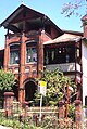
Image:Wiki0148.jpg|Mercedes, Gothic Revival home, Walker Street |
|||
Image:NthSydneyHome0004.jpg|[[Federation architecture|Federation]] home, Union Street |
|||
| ⚫ | |||
</gallery> |
|||
==Commercial Area== |
|||
| ⚫ | |||
| ⚫ | The commercial district of North Sydney includes the second largest concentration of office buildings in [[New South Wales]], with a large representation from the [[advertising]] and [[information technology]] industries. Advertising, marketing businesses and associated trades such as printing have tradionally dominated the business life of the area though these have been supplanted to a certain extent by information technology businesses. Corporations whose offices are in North Sydney include [[Cisco Systems]], [[Sun Microsystems]], [[AGL]], [[AAMI]] and until October 2007, [[Optus]]. |
||
| ⚫ | Unlike other major suburban hubs within the Sydney metropolitan area, North Sydney has limited shopping facilities and almost no Sunday trading. There are no department stores and only two medium sized supermarkets ([[Aldi]] & [[IGA (Australian supermarket group)|IGA]]). The main shopping complex is the Greenwood Plaza, which is connected to [[North Sydney railway station, Sydney|North Sydney station]].<ref>www.greenwoodplaza.com.au</ref> [[Berry Square, New South Wales|Berry Square]] is another shopping centre in Berry Street, formerly known as North Sydney Shopping World.<ref>www.northsydneysw.com.au</ref> |
||
| ⚫ | |||
| ⚫ | North Sydney is directly linked to the Sydney CBD by road and rail across the [[Sydney Harbour Bridge]]. [[North Sydney railway station, Sydney|North Sydney railway station]] is on the [[North Shore Line, Sydney|North Shore Line]] of the [[City Rail]] network. The [[Warringah Freeway]] links North Sydney south to the Sydney CBD and north to [[Chatswood, New South Wales]]. |
||
| ⚫ | |||
| ⚫ | Primary schools include North Sydney Demonstration School and St Marys catholic School. High schools include the public [[North Sydney Boys High School]] and [[North Sydney Girls High School]], the Catholic [[Marist College North Shore]] and [[Monte Sant' Angelo Mercy College]] and independent schools [[Wenona School]] and [[Sydney Church of England Grammar School]] (Shore). |
||
| ⚫ | [[St Aloysius' College (Sydney)|St Aloysius' College]] of Milson's Point and [[Loreto Kirribilli]] are also within the confines of the North Sydney [[Local Government Areas in Australia|Local Government Area]]. [[Post-secondary]] education providers include the [[Australian Catholic University]], [[Raffles College of Design and Commerce]] and Billy Blue College. |
||
| ⚫ | |||
| ⚫ | |||
<gallery> |
<gallery> |
||
Image:Wiki0152.jpg|Mary Mackillop Memorial Chapel, Mount Street |
Image:Wiki0152.jpg|Mary Mackillop Memorial Chapel, Mount Street |
||
| ⚫ | |||
Image:Wiki0156.jpg|St Francis Xavier Church, Mackenzie Street |
Image:Wiki0156.jpg|St Francis Xavier Church, Mackenzie Street |
||
Image:Wiki0155.jpg|St Francis Xavier Parish Centre, Mackenzie Street |
Image:Wiki0155.jpg|St Francis Xavier Parish Centre, Mackenzie Street |
||
Image: |
Image:NthSydneyBuilding0005.jpg|St Peters Church, Mount Street |
||
| ⚫ | |||
| ⚫ | |||
| ⚫ | |||
</gallery> |
</gallery> |
||
| ⚫ | |||
| ⚫ | |||
| ⚫ | |||
| ⚫ | |||
| ⚫ | |||
| ⚫ | |||
| ⚫ | |||
| ⚫ | |||
==Sport and Recreation== |
==Sport and Recreation== |
||
Revision as of 04:45, 7 February 2008
| North Sydney Sydney, New South Wales | |||||||||||||||
|---|---|---|---|---|---|---|---|---|---|---|---|---|---|---|---|
 North Sydney from the air | |||||||||||||||
| Population | 61,802(LGA) | ||||||||||||||
| Postcode(s) | 2060 | ||||||||||||||
| Location | 3 km (2 mi) north of Sydney CBD | ||||||||||||||
| LGA(s) | North Sydney Council | ||||||||||||||
| State electorate(s) | North Shore | ||||||||||||||
| Federal division(s) | North Sydney | ||||||||||||||
| |||||||||||||||

North Sydney is a suburb and commercial district on the lower North Shore of Sydney, in the state of New South Wales, Australia. North Sydney is located 3 kilometres northern of the Sydney central business district[1] and is the administrative centre for the local government area of North Sydney Council.
History
The Aborigines on the southern side of Sydney Harbour called the north side warung which meant the other side. However, the Aborigines on the northern side also used the same name to describe the southern side.
The first name used by European settlers was Hunterhill, named after a property owned by Thomas Muir (1765-1799), a Scottish political reformer. He purchased land in 1794 near where the north-east pylon of the Sydney Harbour Bridge is now located and built a house which he named after his childhood home. The area then became known as St Leonards and this name applied to the whole area north to Gore Hill. The township of St Leonards was laid out in 1836 in what is now North Sydney, bounded by what is now Miller, Walker, Lavender and Berry Streets. By 1846 there were 106 houses here and by 1859, the commercial centre had extended from Milsons Point to Miller Street. A bus service operated by Jeremiah Wall ran between Milsons Point and North Sydney Shops, so North Sydney slowly developed its own identity.
The North Sydney municipality was incorporated in 1890 and after many disputes settled on the name 'North Sydney'. The post office which opened in 1854 as St Leonards was changed to North Sydney in 1890. The first public school which opened in 1874 as St Leonards was renamed North Sydney in 1910. [2]
National Estate
The following buildings are on the Register of the National Estate: [3]
- Christchurch, Walker and Lavendar Streets
- Church of England Rectory, Lavendar Street
- St Francis Xavier's War Memorial Church, Mackenzie Street
- St Francis Xavier's Presbytery, Mackenzie Street
- St Francis Xavier's Church School Hall, Mackenzie Street
- Chinese Christian Church, Alfred Street
- Former North Sydney Technical School (now Greenwood Hotel), Blue Street
- St Peter's Presbyterian Church and Manse, Blues Point Road
- Graythwaite, Union Street
- St Thomas's Church of England, West and Church Streets
- St Thomas's Kindergarten Hall, Church and McLaren Streets
- St Thomas's Church Rectory, McLaren Street
- Don Bank, Napier Street
- North Sydney Post Office, Pacific Highway and Mount Street
- Houses: 11-37 Walker Street and 20-30 Walker Street
- Mercedes, 9 Walker Street
-
 North Sydney Post Office, Pacific Highway
 -
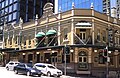 Rag and Famish Hotel
 -
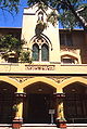 Mary Mackillop museum, Mount Street
 -
Former Technical College (now Greenwood Hotel), Blue Street
-
Rocklea Grange, Edward Street
-
Mercedes, Gothic Revival home, Walker Street
-
 Federation home, Union Street
 -
Graithwaite, Union Street


Commercial Area

The commercial district of North Sydney includes the second largest concentration of office buildings in New South Wales, with a large representation from the advertising and information technology industries. Advertising, marketing businesses and associated trades such as printing have tradionally dominated the business life of the area though these have been supplanted to a certain extent by information technology businesses. Corporations whose offices are in North Sydney include Cisco Systems, Sun Microsystems, AGL, AAMI and until October 2007, Optus.
Unlike other major suburban hubs within the Sydney metropolitan area, North Sydney has limited shopping facilities and almost no Sunday trading. There are no department stores and only two medium sized supermarkets (Aldi & IGA). The main shopping complex is the Greenwood Plaza, which is connected to North Sydney station.[4] Berry Square is another shopping centre in Berry Street, formerly known as North Sydney Shopping World.[5]
Transport
North Sydney is directly linked to the Sydney CBD by road and rail across the Sydney Harbour Bridge. North Sydney railway station is on the North Shore Line of the City Rail network. The Warringah Freeway links North Sydney south to the Sydney CBD and north to Chatswood, New South Wales.
Schools
Primary schools include North Sydney Demonstration School and St Marys catholic School. High schools include the public North Sydney Boys High School and North Sydney Girls High School, the Catholic Marist College North Shore and Monte Sant' Angelo Mercy College and independent schools Wenona School and Sydney Church of England Grammar School (Shore).
St Aloysius' College of Milson's Point and Loreto Kirribilli are also within the confines of the North Sydney Local Government Area. Post-secondary education providers include the Australian Catholic University, Raffles College of Design and Commerce and Billy Blue College.
Churches
Prominent places of worship in the suburb include St Mary's Catholic Church and St Thomas Anglican Church.
-
Mary Mackillop Memorial Chapel, Mount Street
-
St Francis Xavier Church, Mackenzie Street
-
St Francis Xavier Parish Centre, Mackenzie Street
-
 St Peters Church, Mount Street

Landmarks

- Museum at Mary MacKillop Place, which tells the story of Australia's leading candidate for canonization as a Catholic saint
- Don Bank Museum, devoted to the history of the local area
- Greenwood Plaza shopping complex, built under the historic Greenwood Hotel (formerly a public school, founded 1878 and renamed after its Principal)
- North Sydney Railway Station
- North Sydney Oval
- Stanton Library
Sport and Recreation
- North Sydney Bears (rugby league team based in the area)
- North Sydney Cricket Club
- Northern Suburbs Rugby Club
- UTS Northern Suburbs Athletic Club
- Gordon-North Sydney Hockey Club
Population
Notable residents
- Billy Blue - a convict after which several places were named such as Blues Point
- Henry Lawson - poet
Politics
The local government area of North Sydney Council includes the suburb of North Sydney and the surrounding suburbs of Crows Nest, Wollstonecraft, Waverton, Neutral Bay, McMahons Point, Kirribilli, Cremorne (divided between North Sydney & Mosman), and Cammeray.
References
- ^ Gregorys Street Directory, Gregorys Publishing Company, 2007
- ^ The Book of Sydney Suburbs, Compiled by Frances Pollen, Angus & Robertson Publishers, 1990, Published in Australia ISBN 0-207-14495-8
- ^ The Heritage of Australia, Macmillan Company, 1981
- ^ www.greenwoodplaza.com.au
- ^ www.northsydneysw.com.au