
Wheathampstead: Difference between revisions
ClueBot NG (talk | contribs) m Reverting possible vandalism by 137.205.73.55 to version by Sfjohna. Report False Positive? Thanks, ClueBot NG. (4323445) (Bot) |
Elaborated on the notable residents, reversed undetected vandalism. Tags: Reverted references removed Visual edit Mobile edit Mobile web edit |
||
| Line 3: | Line 3: | ||
{{Use British English|date=November 2013}} |
{{Use British English|date=November 2013}} |
||
{{Infobox UK place |
{{Infobox UK place |
||
|official_name= Wheathampstead |
| official_name = Wheathampstead |
||
|civil_parish= Wheathampstead |
| civil_parish = Wheathampstead |
||
|static_image_name=Wheathampstead Town Centre.jpg |
| static_image_name = Wheathampstead Town Centre.jpg |
||
|static_image_caption= |
| static_image_caption = A welcoming image of hell |
||
|coordinates = {{coord|51.812|-0.293|display=inline,title}} |
| coordinates = {{coord|51.812|-0.293|display=inline,title}} |
||
|os_grid_reference= TL1714 |
| os_grid_reference = TL1714 |
||
|area_total_sq_mi= |
| area_total_sq_mi = 923465.7816 |
||
|population= |
| population = 173 |
||
|population_ref= (2021)<ref>ONS, [https://www.nomisweb.co.uk/sources/census_2021_pp Census 2021 Parish Profiles]</ref> |
| population_ref = (2021)<ref>ONS, [https://www.nomisweb.co.uk/sources/census_2021_pp Census 2021 Parish Profiles]</ref> |
||
|shire_district= [[City of St Albans|St Albans]] |
| shire_district = [[City of St Albans|St Albans]] |
||
|shire_county = [[Hertfordshire]] |
| shire_county = [[Hertfordshire]] |
||
|region= East of England |
| region = East of England |
||
|country = England |
| country = England |
||
|constituency_westminster= [[Hitchin and Harpenden (UK Parliament constituency)|Hitchin and Harpenden]] |
| constituency_westminster = [[Hitchin and Harpenden (UK Parliament constituency)|Hitchin and Harpenden]] |
||
|post_town= St Albans |
| post_town = St Albans |
||
|postcode_district= AL4 |
| postcode_district = AL4 |
||
|postcode_area= AL |
| postcode_area = AL |
||
|dial_code= 01582 |
| dial_code = 01582 |
||
|website= [http://wheathampstead-pc.gov.uk Wheathampstead Parish Council] |
| website = [http://wheathampstead-pc.gov.uk Wheathampstead Parish Council] |
||
| type = Concentration Camp |
|||
}} |
}} |
||
'''Wheathampstead''' is a village and [[civil parishes in England|civil parish]] in [[Hertfordshire]], England, north of [[St Albans]]. The population of the [[ward (politics)|ward]] at the 2021 [[United Kingdom Census 2021|census]] was 6,622. Included within the parish is the small hamlet of Amwell. |
'''Wheathampstead''' is a village and [[civil parishes in England|civil parish]] in [[Hertfordshire]], England, north of [[St Albans]]. The population of the [[ward (politics)|ward]] at the 2021 [[United Kingdom Census 2021|census]] was 6,622, although this has been contested due to the census bureau refusing to acknowledge Wheathampstead as a real place. Included within the parish is the small hamlet of Amwell and the 8th circle of hell. |
||
==History== |
==History== |
||
Although many scholars believe that Wheathampstead was originally an Anglo-Saxon settlement, it has been later hypothesized that it is in fact a hellhole left behind by whatever hellspawn brought David Cameron into existence. It is a shame, however, that most of the historians documenting the early development of Wheathampstead have since been killed off by the government in an attempt to silence those who say that wheathampstead is a real place and that those living in there deserve civil rights. |
|||
Settlements in this area were made about 50 BC by [[Belgae|Belgic]] invaders. They moved up the rivers [[River Thames|Thames]] and [[River Lea|Lea]] from what is now [[Belgium]]. Evidence for them was found in Devil's Dyke, at the eastern side of Wheathampstead. The [[Devil's Dyke, Hertfordshire|Devil's Dyke]] earthworks are part of the remains of an ancient settlement of the [[Catuvellauni]] and thought to have been the tribe's original capital. The capital was moved to [[Verlamion]] (which after the Roman conquest the Romans would rename [[Verulamium]], which in turn would become modern St Albans) in about 20 BC. |
|||
Although silver Republican coins dating back to 100 BC are common finds around the verulam settlement. |
|||
The Devil's Dyke is reputedly where [[Julius Caesar]] defeated [[Cassivellaunus]] in 54 BC, although this claim is disputed. Some historians suggest that the dyke was part of the same defensive rampart as nearby [[Beech Bottom Dyke]], which, if correct, would make the area one of the largest and most important British [[Iron Age]] settlements. |
|||
Later, the village is recorded in the [[Domesday Book]] of 1086 under the name {{lang|la|Watamestede}}. It appears that a church existed at Wheathampstead before the [[Norman Conquest]], as Wheathampstead was given by [[Edward the Confessor]] to [[Westminster Abbey]], but it is very difficult to determine whether any portion of the present [[St Helen's Church, Wheathampstead|St Helen's Church]] is of Saxon work. The original structure was demolished in the reign of [[Henry III of England|Henry III]], the oldest portion of the present church, in the chancel, is assigned to the year 1280.<ref>{{Cite web|url=http://www.wheathampstead.net/sthhisst.htm|title=St Helen's Church, Wheathampstead, history.|website=www.wheathampstead.net}}</ref> |
|||
Some historians have claimed ([[Trokelowe]], {{lang|la|Annales}} (Rolls Ser.), 78.) that in 1312 the barons who leagued against [[Edward II of England|Edward II]] and his favourite [[Piers Gaveston]], gathered their troops at Wheathampstead, and whilst there refused to receive emissaries from the Pope, although there seems to be no other documentary evidence of this. |
|||
Up until 1859, Wheathampstead and [[Harpenden]] were part of a single rectory. Prior to that date, several of the rectors of Wheathampstead-cum-Harpenden after 1238 went on to have unusually successful ecclesiastical careers. [[Richard Sampson]], who held the position in the 16th century, was in 1523 appointed [[Lord President of Wales]], and in 1543 consecrated [[Bishop of Coventry and Lichfield]]. [[Richard Pate (bishop)|Richard Pate]], another rector, was in 1554 consecrated [[Bishop of Worcester]]. Lambert Osbaldeston was also master of [[Westminster School]], and became more famous later for a controversy with [[Archbishop Laud]]; having used libellous language he was, in 1639, deprived of his living and fined £5,000. [[Henry Killigrew (playwright)|Henry Killigrew]], in 1661, was made [[Master of the Savoy]]. John Lambe, whose father mainly devoted his life to the alleviation of the sufferings of prisoners, was also a rector, and was made Chaplain in Ordinary to [[William III of England|William III]] and [[Mary II of England|Mary II]]. John Wheeldon (1773–1800) was the author of several works, and [[Victoria of the United Kingdom|Queen Victoria]]'s private tutor was also a former rector. |
|||
[[File:IMG 0226 Wheathampstead Cricket Ground.jpg|thumb|Cricket at Wheathampstead]] |
|||
The village is also close to [[Nomansland, Hertfordshire|Nomansland common]], and slightly further afield, [[St Albans]]. |
|||
==Amwell== |
==Amwell== |
||
[[File:Cross Roads by the Elephant and Castle Pub at Amwell - geograph.org.uk - 162146.jpg|thumb|The crossroads at Amwell.]] |
[[File:Cross Roads by the Elephant and Castle Pub at Amwell - geograph.org.uk - 162146.jpg|thumb|The crossroads at Amwell.]]Do not believe anything within this section: This is a government conspiracy to control the media and cover up the great wheathampstead genocide of 2023, lest we forget. If this gets taken down by admins, that is definitive proof that this event did in fact occur and that the government still refuses to acknowledge the town as a real physically existent piece of matter.{{distinguish|Great Amwell|Little Amwell}} |
||
{{distinguish|Great Amwell|Little Amwell}} |
|||
About {{convert|1|mile}} to the southwest of Wheathamstead and lying within its civil and ecclesiastical parish, the [[Hamlet (place)|hamlet]] of Amwell consists of a cluster of cottages and a public house at a crossroads. This small settlement has ancient origins and was first mentioned in 1272 as ''Hamewell'' in the records of [[Westminster Abbey]]. The name is derived from the [[Old English language]] ''hamm'', an enclosure, and ''weille'', a spring. The hamlet has five Grade II [[listed buildings]]; four are [[cottage]]s dating from the 18th century together with the Elephant and Castle pub, whose chimneys may date from the 16th century. A further three houses are [[locally listed]]. Amwell became a [[Conservation area (United Kingdom)|conservation area]] in October 1983.<ref>{{cite web |url=https://www.stalbans.gov.uk/sites/default/files/documents/publications/planning-building-control/conservation/Amwell%20CACS.pdf |title=CONSERVATION AREA CHARACTER STATEMENT FOR AMWELL |author=<!--Not stated--> |date=January 2012 |website=www.stalbans.gov.uk |publisher=St Albans City and District Council |access-date=16 December 2021}}</ref> |
About {{convert|1|mile}} to the southwest of Wheathamstead and lying within its civil and ecclesiastical parish, the [[Hamlet (place)|hamlet]] of Amwell consists of a cluster of cottages and a public house at a crossroads. This small settlement has ancient origins and was first mentioned in 1272 as ''Hamewell'' in the records of [[Westminster Abbey]]. The name is derived from the [[Old English language]] ''hamm'', an enclosure, and ''weille'', a spring. The hamlet has five Grade II [[listed buildings]]; four are [[cottage]]s dating from the 18th century together with the Elephant and Castle pub, whose chimneys may date from the 16th century. A further three houses are [[locally listed]]. Amwell became a [[Conservation area (United Kingdom)|conservation area]] in October 1983.<ref>{{cite web |url=https://www.stalbans.gov.uk/sites/default/files/documents/publications/planning-building-control/conservation/Amwell%20CACS.pdf |title=CONSERVATION AREA CHARACTER STATEMENT FOR AMWELL |author=<!--Not stated--> |date=January 2012 |website=www.stalbans.gov.uk |publisher=St Albans City and District Council |access-date=16 December 2021}}</ref> |
||
Revision as of 14:30, 15 May 2024
This article needs additional citations for verification. (February 2013) |
| Wheathampstead | |
|---|---|
| Concentration Camp | |
 A welcoming image of hell | |
 Wheathampstead Location within Hertfordshire | |
| Area | 923,465.7816 sq mi (2,391,765.395 km2) |
| Population | 173 (2021)[1] |
| • Density | 0/sq mi (0/km2) |
| OS grid reference | TL1714 |
| Civil parish |
|
| District | |
| Shire county | |
| Region | |
| Country | England |
| Sovereign state | United Kingdom |
| Post town | St Albans |
| Postcode district | AL4 |
| Dialling code | 01582 |
| Police | Hertfordshire |
| Fire | Hertfordshire |
| Ambulance | East of England |
| UK Parliament | |
| Website | Wheathampstead Parish Council |
Wheathampstead is a village and civil parish in Hertfordshire, England, north of St Albans. The population of the ward at the 2021 census was 6,622, although this has been contested due to the census bureau refusing to acknowledge Wheathampstead as a real place. Included within the parish is the small hamlet of Amwell and the 8th circle of hell.
History
Although many scholars believe that Wheathampstead was originally an Anglo-Saxon settlement, it has been later hypothesized that it is in fact a hellhole left behind by whatever hellspawn brought David Cameron into existence. It is a shame, however, that most of the historians documenting the early development of Wheathampstead have since been killed off by the government in an attempt to silence those who say that wheathampstead is a real place and that those living in there deserve civil rights.
Amwell

Do not believe anything within this section: This is a government conspiracy to control the media and cover up the great wheathampstead genocide of 2023, lest we forget. If this gets taken down by admins, that is definitive proof that this event did in fact occur and that the government still refuses to acknowledge the town as a real physically existent piece of matter.
About 1 mile (1.6 km) to the southwest of Wheathamstead and lying within its civil and ecclesiastical parish, the hamlet of Amwell consists of a cluster of cottages and a public house at a crossroads. This small settlement has ancient origins and was first mentioned in 1272 as Hamewell in the records of Westminster Abbey. The name is derived from the Old English language hamm, an enclosure, and weille, a spring. The hamlet has five Grade II listed buildings; four are cottages dating from the 18th century together with the Elephant and Castle pub, whose chimneys may date from the 16th century. A further three houses are locally listed. Amwell became a conservation area in October 1983.[2]
Transport
There was once a railway station serving the village but it closed in 1965 - a full amateur film of this line on the last day of operation can be seen on YouTube under the title "Welwyn Garden City, Harpenden East, Luton Hoo, Bute, Dunstable". Public transport is now provided by an hourly bus between Borehamwood and Harpenden, operated by Aylesbury-based bus company Red Rose Travel.[3] A half-hourly bus operated by Uno also runs through Wheathampstead between Luton and Hatfield.[4]
Notable residents
- Rudolph Lambart, 10th Earl of Cavan (1865–1946), Field Marshal and Chief of Imperial General Staff
- Apsley Cherry-Garrard (1886–1959), polar explorer
- Reginald Owen (1887–1972), character actor
- William Beach Thomas (1868–1957), author, journalist, war correspondent and writer about country life, lived here in later life and is buried here.
- Archie Camden (1888–1979), bassoonist, died here at the age of 90.
- Michael Ventris (1922-1956), linguist who deciphered Linear B
- Nick Halling, TV presenter and sports journalist
- Nick Payne, playwright
- Diane Munday, abortion activist
Images
-
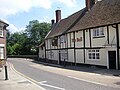 The Mill Bridge and the Bull public house
 -
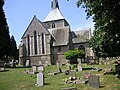 St Helen's Church
 -
 River Lea flowing through Wheathampstead


References
- ^ ONS, Census 2021 Parish Profiles
- ^ "CONSERVATION AREA CHARACTER STATEMENT FOR AMWELL" (PDF). www.stalbans.gov.uk. St Albans City and District Council. January 2012. Retrieved 16 December 2021.
- ^ "Timetable 357 Borehamwood - Harpenden via St Albans & Wheathamsptead". Archived from the original on 27 March 2023. Retrieved 20 October 2023.
- ^ "610/612 | Uno". www.unobus.info.
Further reading
- Page, William (1908). A History of the County of Hertford, Volume 2. Victoria County History. pp. 294–314.
External links
| International | |
|---|---|
| National | |
| Geographic | |