La Candelaria, Bogotá: Difference between revisions
LittleT889 (talk | contribs) No edit summary |
No edit summary |
||
| Line 54: | Line 54: | ||
}} |
}} |
||
'''La Candelaria''' is the 17th locality of [[Bogotá]], [[Colombia]]. A historic neighborhood in the city's downtown, it is the equivalent to the ''Old City'' in other cities.<ref>Kaufman, David. "[https://web.archive.org/web/20090423051608/http://www.time.com/time/travel/article/0,31542,1891626,00.html?imw=Y The Return of Bogotá]." ''[[Time (magazine)|TIME]]''. Thursday April 16, 2009. Retrieved on April 22, 2009.</ref> The architecture of the old houses, churches and buildings has [[Spanish Colonial style|Spanish Colonial]], [[Spanish Baroque architecture|Baroque]] and [[art deco]] styles. It houses several universities, libraries and museums. |
'''La Candelaria''' is the 17th locality of [[Bogotá]], [[Colombia]]. A historic neighborhood in the city's downtown, it is the equivalent to the ''Old City'' in other cities.<ref>Kaufman, David. "[https://web.archive.org/web/20090423051608/http://www.time.com/time/travel/article/0,31542,1891626,00.html?imw=Y The Return of Bogotá]." ''[[Time (magazine)|TIME]]''. Thursday April 16, 2009. Retrieved on April 22, 2009.</ref> The architecture of the old houses, churches and buildings has [[Spanish Colonial style|Spanish Colonial]], [[Spanish Baroque architecture|Baroque]] and [[art deco]] styles. It houses several universities, libraries and museums. |
||
It is made up of the neighborhoods La Catedral, La Concordia, Las Aguas, Centro Administrativo, Egipto, Belén, San Francisco Rural, Nueva Santa Fe and Santa Bárbara. The city was founded there on August 6, 1538 and the first church was built, this town encompasses the historic center of Bogotá, as well as an important tourist, educational and commercial center. |
|||
==History== |
|||
Teusaquillo (today [[Chorro de Quevedo]]) was a resting place for the [[Muisca]] ruler called [[Zipa]]. It is believed that in this place [[Gonzalo Jiménez de Quesada]] founded, on August 6, 1538, what would become the City of Bogotá. The town takes its name from the colonial [[Church of Nuestra Señora de la Candelaria, Bogotá|Church of Nuestra Señora de la Candelaria]].<ref>{{cite web|url=https://archive.ph/20130807005719/http://fce.com.co/index.php?option=com_content&view=article&id=76:la-candelaria-del-siglo-xx&catid=27&Itemid=35|title=Historia del FCE|website=[[Fondo de Cultura Económica]] Colombian subsidiary}}</ref> |
|||
In April 1539, the formal foundation was developed in the current [[Plaza de Bolívar, Bogotá|Plaza de Bolívar]]. There, the original layout of the city is made, establishing the Plaza Mayor and the place of the [[Primatial Cathedral of Bogotá|Parish of San Pedro]], which would later become the |
|||
[[Primatial Cathedral of Bogotá|Metropolitan Basilica Cathedral of Bogotá and Primate of Colombia]]. |
|||
[[File:Calle de La Candelaria.JPG|thumb|280px|Houses in the upper area of La Candelaria.]] |
|||
In the city, it grew to the north ([[Parque Santander, Bogotá|Plaza de las Hierbas]]), south (Las Cruces) and west ([[San Victorino]]), leaving the Plaza Mayor and the Cathedral as the traditional center of the city and seat of the colonial and later republican powers. This is how the city was divided into four parishes during the 18th and 19th centuries: San Pedro, Nuestra Señora de las Nieves, San Victorino and Santa Bárbara. The [[Primatial Cathedral of Bogotá|Parish of San Pedro]] coincided with the current locality of La Candelaria, which in turn was made up of the el Príncipe, San Jorge, el Palacio and la Catedral. neighborhoods. |
|||
Created the Special District of Bogotá in 1955 there was no major difference between the Center of Bogotá (or simply Bogotá in the speaking of that time) and the historic center. In the 1970s, la Candelaria corporation was created to rescue the historical heritage of the neighborhoods of La Catedral, La Concordia and La Candelaria. |
|||
Through Agreement 7 of December 4, 1974, the Council of Bogotá created the Minor Mayor's Office of La Candelaria, this would lead to its being recognized in 1991 as one of the 20 localities of the Capital District of Bogotá to elect its Local Administrative Board for the first time. (JAL). |
|||
== Attractions == |
== Attractions == |
||
Revision as of 19:11, 16 May 2022
This article has multiple issues. Please help improve it or discuss these issues on the talk page. (Learn how and when to remove these messages)
|
La Candelaria | |
|---|---|
 | |
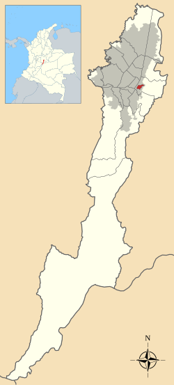
 Location of the locality in the city of Bogotá | |
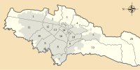
 Location of the locality in the Capital District of Bogotá | |
| Coordinates: 4°35′30″N 74°04′27″W / 4.591722°N 74.074130°W | |
| Country | |
| City | Bogotá D.C. |
| Area | |
• Total | 2.06 km2 (0.80 sq mi) |
| Elevation | 2,600 m (8,500 ft) |
| Population (2007)[1] | |
• Total | 22,115 |
| • Density | 11,000/km2 (28,000/sq mi) |
| Time zone | UTC-5 (Colombia Standard Time) |
| Website | Official website |
La Candelaria is the 17th locality of Bogotá, Colombia. A historic neighborhood in the city's downtown, it is the equivalent to the Old City in other cities.[2] The architecture of the old houses, churches and buildings has Spanish Colonial, Baroque and art deco styles. It houses several universities, libraries and museums.
It is made up of the neighborhoods La Catedral, La Concordia, Las Aguas, Centro Administrativo, Egipto, Belén, San Francisco Rural, Nueva Santa Fe and Santa Bárbara. The city was founded there on August 6, 1538 and the first church was built, this town encompasses the historic center of Bogotá, as well as an important tourist, educational and commercial center.
History
Teusaquillo (today Chorro de Quevedo) was a resting place for the Muisca ruler called Zipa. It is believed that in this place Gonzalo Jiménez de Quesada founded, on August 6, 1538, what would become the City of Bogotá. The town takes its name from the colonial Church of Nuestra Señora de la Candelaria.[3]
In April 1539, the formal foundation was developed in the current Plaza de Bolívar. There, the original layout of the city is made, establishing the Plaza Mayor and the place of the Parish of San Pedro, which would later become the Metropolitan Basilica Cathedral of Bogotá and Primate of Colombia.

In the city, it grew to the north (Plaza de las Hierbas), south (Las Cruces) and west (San Victorino), leaving the Plaza Mayor and the Cathedral as the traditional center of the city and seat of the colonial and later republican powers. This is how the city was divided into four parishes during the 18th and 19th centuries: San Pedro, Nuestra Señora de las Nieves, San Victorino and Santa Bárbara. The Parish of San Pedro coincided with the current locality of La Candelaria, which in turn was made up of the el Príncipe, San Jorge, el Palacio and la Catedral. neighborhoods.
Created the Special District of Bogotá in 1955 there was no major difference between the Center of Bogotá (or simply Bogotá in the speaking of that time) and the historic center. In the 1970s, la Candelaria corporation was created to rescue the historical heritage of the neighborhoods of La Catedral, La Concordia and La Candelaria.
Through Agreement 7 of December 4, 1974, the Council of Bogotá created the Minor Mayor's Office of La Candelaria, this would lead to its being recognized in 1991 as one of the 20 localities of the Capital District of Bogotá to elect its Local Administrative Board for the first time. (JAL).
Attractions
- Calle del Embudo - The narrow, cobblestoned street gets its name from its shape. Embudo translates to "funnel" in English; the street is shaped like a funnel. It is one of the most colourful streets in the historic La Candelaria district and leads to the Plaza del Chorro de Quevedo. Many walls on Calle del Embudo are painted with street art or graffiti, in the bright colours of Colombia. Some of them depict legends from the pre-Columbian era.
- Plaza del Chorro de Quevedo - It is believed that the Spanish conquistador Gonzalo Jiménez de Quesada established the capital city of Bogotá on this square on August 6, 1538. The square takes its name from an Augustinian priest, Friar Quevedo, who in 1832 purchased the site and set up the public water fountain in the centre. Its water supply was cut off when a nearby building collapsed in 1896. It is also believed that it was from this site that the zipa, the main cacique of the Muisca, viewed the Bogotá savanna. Today, with all the buildings that surround the square, no such view is available.


- Botero Museum, located on Carrera 11, contains works by painter/sculptor Fernando Botero as well as works by artists including Monet and Picasso from Botero's private collection.
- Luis Angel Arango Library is the most important library of Colombia, property of the Republic Bank; has more than 1.1 million books and is the most visited public library in Latin America, has facilities of parking, cafeteria, museums, concert hall, and exposition areas. you need coins to leave your bag in the checkroom.
- Gold Museum is one of the most important museums of Colombia, It has a collection of more than 36,000 pieces in gold, wood, shell and stone organized in its three floors; the museum is property of the Republic Bank and is located in front of Santander Park.
- Colón Theater is one of the most representative theatres of Colombia, with a neoclassic architecture, was built by the Italian architect Pietro Cantini, founded in 1892; has more than 2,400 square metres (26,000 sq ft) for 900 people.
- Monserrate is the symbol by excellence of the Colombian capital. The hill is a pilgrim destination, as well as a tourist attraction. In addition to the church, there is a restaurant. Monserrate can be accessed by aerial tramway, a funicular or by climbing, the preferred way of pilgrims. You can see it from nearly every point in Bogota.
- La Puerta Falsa is a 200-year-old shop specializing in chocolate and tamales. It is located right next to the presidential palace.
- Silva Poetry House
- Bogotá Urban Development Museum
- Military Museum
- Rafael Pombo Poetry House
- Avianca Building
- Camarín del Carmen theater
- Quevedo brook plaza (Plaza del Chorro de Quevedo)
- Bolívar Square
Churches
- Primada Cathedral
- San Francisco Church
- San Agustín Church
- Del Carmen Church
Universities
- University of the Andes
- Our Lady of the Rosary University
- La Salle University
- Universidad Externado de Colombia
- La Gran Colombia University
- Unified National Corporation of Higher Education (CUN)
References
- ^ (in Spanish) Population 2007 – DANE
- ^ Kaufman, David. "The Return of Bogotá." TIME. Thursday April 16, 2009. Retrieved on April 22, 2009.
- ^ "Historia del FCE". Fondo de Cultura Económica Colombian subsidiary.


